
Founded February 5, 1777 Website www.augustaga.gov Population 202,003 (2013) | Area 852.1 km² County seat Augusta | |
 | ||
Colleges and Universities Augusta University, Augusta State University, Paine College, Augusta Technical College, Medical College of Georgia Points of interest Augusta Canal, Augusta Museum of History, Woodrow Wilson Boyhood, Morris Museum of Art, Sacred Heart Catholic | ||
Richmond County is a county located in the U.S. state of Georgia. As of the 2010 census, the population was 200,549. It is one of the original counties of Georgia, created February 5, 1777.
Contents
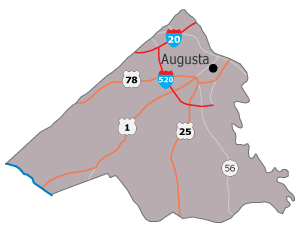
- Map of Richmond County GA USA
- History
- Geography
- Adjacent counties
- Demographics
- Communities
- Notable person
- References
Map of Richmond County, GA, USA
Following an election in 1995, the city of Augusta (the county seat) consolidated governments with Richmond County. The consolidated entity is known as Augusta-Richmond County, or simply Augusta. The cities of Hephzibah and Blythe in southern Richmond County voted to remain separate and not consolidate.
Richmond County is included in the Augusta-Richmond County, GA-SC Metropolitan Statistical Area.
History
The county is named for Charles Lennox, 3rd Duke of Richmond, a British politician and office-holder sympathetic to the cause of the American colonies. Richmond was also a first cousin to King George III.
Richmond County was established in 1777 by the first Constitution of the (newly independent) State of Georgia. As such, it is one of the original counties of the state. It was formed out of a portion of the colonial Parish of St. Paul, after the Revolution disestablished the Church of England in the (former) Royal Province of Georgia.
Geography
According to the U.S. Census Bureau, the county has a total area of 329 square miles (850 km2), of which 324 square miles (840 km2) is land and 4.3 square miles (11 km2) (1.3%) is water.
The vast majority of Richmond County is located in the Middle Savannah River sub-basin of the Savannah River basin, with just the southwestern corner of the county, from a line running north from Blythe through the middle of Fort Gordon, located in the Brier Creek sub-basin of the Savannah River basin.
Adjacent counties
Demographics
As of the 2010 United States Census, there were 200,549 people, 76,924 households, and 48,641 families residing in the county. The population density was 618.4 inhabitants per square mile (238.8/km2). There were 86,331 housing units at an average density of 266.2 per square mile (102.8/km2). The racial makeup of the county was 54.2% black or African American, 39.7% white, 1.7% Asian, 0.3% American Indian, 0.2% Pacific islander, 1.3% from other races, and 2.6% from two or more races. Those of Hispanic or Latino origin made up 4.1% of the population. In terms of ancestry, 8.0% were American, 7.0% were Irish, 6.7% were German, and 5.3% were English.
Of the 76,924 households, 33.6% had children under the age of 18 living with them, 35.6% were married couples living together, 22.6% had a female householder with no husband present, 36.8% were non-families, and 30.4% of all households were made up of individuals. The average household size was 2.47 and the average family size was 3.09. The median age was 33.2 years.
The median income for a household in the county was $37,882 and the median income for a family was $45,220. Males had a median income of $37,368 versus $29,313 for females. The per capita income for the county was $20,604. About 19.4% of families and 23.3% of the population were below the poverty line, including 36.5% of those under age 18 and 12.1% of those age 65 or over.