
- right Penholoway Creek - location Altamaha Sound Basin area 36,260 km² Length 220 km | - elevation 82 ft (25 m) - elevation 0 ft (0 m) Discharge 382.8 m³/s | |
 | ||
- average 13,520 cu ft/s (383 m/s) Bridges Dr. J. Alvin Leaphart Sr. Memorial Bridge Cities | ||
Canoeing the oconee river to the altamaha river dublin georgia
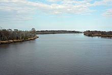
The Altamaha River /ˈɑːltəməhɑː/ is a major river in the U.S. state of Georgia. It flows generally eastward for 137 miles (220 km) from its origin at the confluence of the Oconee River and Ocmulgee River towards the Atlantic Ocean, where it empties into the ocean near Brunswick, Georgia. There are no dams directly on the Altamaha, though there are some on the Oconee and the Ocmulgee. Including its tributaries, the Altamaha River's drainage basin is about 14,000 square miles (36,000 km2) in size, qualifying it among the larger river basins of the US Atlantic coast. It is reportedly the third largest contributor of fresh water to the Atlantic Ocean from North America. Including its longest tributary (the Ocmulgee River) in length calculations as is standard USGS practice, its length of 470 miles (760 km) places it seventh on the list of U.S. rivers entirely within one state, behind only four Alaskan rivers, the Sacramento-Pit River in California, and the Trinity River in Texas. The beginning of the Colorado River of Texas is just within New Mexico. The long Mobile-Alabama-Coosa River system, mostly in Alabama, originates a short distance within Georgia.
Contents
- Canoeing the oconee river to the altamaha river dublin georgia
- Map of Altamaha River Georgia USA
- The origin of the altamaha river
- Course
- Natural history
- History
- References
Map of Altamaha River, Georgia, USA
The Altamaha River traverses a broad area of low population density with few significant towns or cities along its course. There are some along its upper tributaries, such as the fall line cities of Milledgeville on the Oconee and Macon on the Ocmulgee. Centuries ago, riverboats used the Altamaha to reach those towns and the plantations founded along the rivers, which were the main transportation routes.
According to the USGS, variant and historical names of the Altamaha River include A-lot-amaha, Alatahama, Alatamaha, Allamah, Frederica River, Rio Al Tama, Rio de Talaje, and Talaxe River.
The 1,759-megawatt Plant Hatch nuclear power plant sits on the southern bank of the Altamaha River in Appling County. A Rayonier paper mill that manufactures cellulose fibers used in plastics and absorbent materials for diapers, tampons and other products is located on the southern bank of the Altamaha River in Wayne County.
The origin of the altamaha river
Course
The Altamaha River originates at the confluence of the Oconee River and Ocmulgee River, near Lumber City. At its source, the Altamaha River forms the border between Jeff Davis County to the south and Montgomery County to the north.
Bullard Creek Wildlife Management Area occupies the southern floodplain of the river's first few miles, after which the river marks the boundary between Toombs County to the north and Appling County to the south.
On the north side, Toombs County gives way to Tattnall County, in which the Ohoopee River joins the Altamaha. The Big Hammock Wildlife Management Area and Big Hammock Natural Area are located along the Altamaha at the Ohoopee confluence. Big Hammock Natural Area is a National Natural Landmark site, noted for its ecological biodiversity and many rare plant species, including Georgia plume.
Below Big Hammock, the tributary Beards Creek joins the Altamaha River from the north, after which the river marks the border between Long County to the north and Wayne County to the south. The Altamaha passes through Griffin Ridge Wildlife Management Area before flowing by Doctortown, near Jesup. A wide and swampy floodplain surrounds the river in this area.
Several miles below Doctortown Wayne County gives way to McIntosh County on the north side of the river. From this point to the river's mouth there are numerous wildlife management areas. The Sansaville Wildlife Management Area lies on the south side of the river, while the Altamaha Wildlife Management Area lies on the north and extends down to the river's mouth at Altmaha Sound. Wolf Island National Wildlife Refuge occupies Wolf Island on the Atlantic coast, north of Altamaha Sound. In its last several miles, the Altamaha River marks the boundary between McIntosh County on the north and Glynn County on the south.
The town of Darien lies just north of the Altamaha River's mouth. Several miles to the south lies the larger city of Brunswick. St. Simons Island lies on the south side of the Altamaha estuary. The estuary of the Altamaha River, where fresh and salt water mix, is about 26 square miles (67 km2) in size, one of the largest intact, relatively non-degraded estuary on the Atlantic coast. The Altamaha River Delta has been designated as a site of regional importance to shorebirds by the Western Hemisphere Shorebird Reserve Network (WHSRN).
Natural history
Although used in the 19th century as a route for commerce between central Georgia and the coast, the river is nearly entirely still in its natural state, and was designated a bioreserve by The Nature Conservancy in 1991. Over 100 rare or endangered species may be found in the river basin, and the delta is a major stopover for many species of migratory birds.
The Altamaha River flows through a flood plain up to five miles (8 km) wide, consisting of some of the last remaining hardwood bottomlands and cypress swamps in the American South. As the river approaches the Atlantic Ocean, it becomes a broad estuary. At least 120 species of rare or endangered plants and animals live in the Altamaha River watershed, including 11 species of pearly mussels, seven of which are endemic to the Altamaha. The river basin also supports the only known example of old-growth longleaf pine and black oak forest in the United States. Other notable species include shortnose sturgeon, Atlantic sturgeon, West Indian manatee, Eastern indigo snake (Drymarchon couperi), greenfly orchid, and Georgia plume. The unusual Franklin tree (Franklinia alatamaha), now extinct in the wild, was found by John Bartram along the Altamaha River in 1765. Bartram sent seeds from the trees to England and planted some in his garden in Philadelphia, where some still live.
History
In prehistoric times the Timucua people occupied northern Florida and a portion of Georgia reaching as far north as the Altamaha River. The Utinahica tribe lived along the river and the Spanish mission of Santa Isabel de Utinahica was established around 1610 near the source of the Altamaha. Along the coast of Spanish Florida the Altamaha River marked the boundary between the Guale and Mocama missionary provinces.
New research announced in February 2014 indicates that Fort Caroline, built by the French in 1564 and probably the oldest European fortified settlement in North America, was likely constructed near the mouth of the Altamaha River. Historian Fletcher Crowe noted: “This fort is older than St. Augustine, considered to be the oldest continuously inhabited city in America." It was long believed the legendary fort was located near today’s city of Jacksonville, but detailed archival research in France on Fort Caroline and the early history of ‘La Floride Française’ has proved that wrong, suggesting the Altamaha mouth location as highly likely. The site still remains to be excavated by archaeologists. In 1565, Spanish soldiers under Pedro Menéndez marched into Fort Caroline and slaughtered some 143 men and women who were living there at the time.Science Daily, 23 Feb. 2014
In the later 17th century a group of Yamasee Indians under Chief Altamaha took up residence near the mouth of the Altamaha.
The Altamaha River marked the western border of the Colony of Georgia until the American Revolution and therefore the western border of the English settlement in North America. It also marked the boundary between the Spanish missionary provinces of Guale and Mocama. The name comes from a Yamasee chief named Altamaha.
In 1770, Oliver Goldsmith referred to the river in The Deserted Village (ll. 343–358):
"Through torrid tracts with fainting steps they go,Where wild Altamaha murmurs to their woe.Far different there from all that charm'd before,The various terrors of that horrid shore;Those blazing suns that dart a downward ray,And fiercely shed intolerable day;Those matted woods where birds forget to sing,But silent bats in drowsy clusters cling;Those poisonous fields, with rank luxuriance crown'd,Where the dark scorpion gathers death around;Where at each step the stranger fears to wakeThe rattling terrors of the vengeful snake;Where crouching tigers wait their hapless prey,And savage men more murderous still than they:While oft in whirls the mad tornado flies,Mingling the ravag'd landscape with the skies."In 2004, filmmaker Les Stroud taped an episode of his show Survivorman in the swamps of the Altamaha basin.