
Website www.tulsacounty.org Area 1,520 km² | Largest city Tulsa Founded 1907 Population 622,409 (2013) | |
 | ||
Points of interest Philbrook Museum of Art Colleges and Universities Community Care College, University of Tulsa, Tulsa Community College, Oral Roberts University, Clary Sage College Destinations | ||
Watch tornado forms in tulsa county oklahoma
Tulsa County is a county located in the U.S. state of Oklahoma. As of the 2010 census, the population was 603,403, making it the second-most populous county in Oklahoma, behind only Oklahoma County. Its county seat and largest city is Tulsa, the second-largest city in the state. Founded at statehood, in 1907, it was named after the previously established city of Tulsa. Before statehood, the area was part of both the Creek Nation and the Cooweescoowee District of Cherokee Nation in Indian Territory.
Contents
- Watch tornado forms in tulsa county oklahoma
- Map of Tulsa County OK USA
- History
- Lasley Vore Site
- Old Fort Arbuckle
- Battle of Chusto Talasah
- Coming of the railroads
- Oil Boom
- Tulsa County Court House
- Geography and climate
- Adjacent counties
- Demographics
- Politics
- Parks and recreation
- Towns
- Census designated places
- Unincorporated communities
- Former communities
- NRHP sites
- References
Map of Tulsa County, OK, USA
Tulsa County is included in the Tulsa, OK Metropolitan Statistical Area.
Tulsa County is notable for being the most densely populated county in the state. Tulsa County also ranks as having the highest-income.
History
The history of Tulsa County greatly overlaps the history of the city of Tulsa. This section addresses events that largely occurred outside the present city limits of Tulsa.
Lasley Vore Site
The Lasley Vore Site, along the Arkansas River south of Tulsa, was claimed by University of Tulsa anthropologist George Odell to be the most likely place where Jean-Baptiste Bénard de la Harpe first encountered a group of Wichita people in 1719. Odell's statement was based on finding both Wichita and French artifacts there during an architectural dig in 1988.
Old Fort Arbuckle
The U. S. Government's removal of Native American tribes from the southeastern United States to "Indian Territory" did not take into account how that would impact the lives and attitudes of the nomadic tribes that already used the same land as their hunting grounds. At first, Creek immigrants stayed close to Fort Gibson, near the confluence of the Arkansas and Verdigris rivers. However, the government encouraged newer immigrants to move farther up the Arkansas. The Osage tribe had agreed to leave the land near the Verdigris, but had not moved far and soon threatened the new Creek settlements.
In 1831, a party led by Rev. Isaac McCoy and Lt. James L. Dawson blazed a trail up the north side of the Arkansas from Fort Gibson to its junction with the Cimarron River. In 1832, Dawson was sent again to select sites for military posts. One of his recommended sites was about two and a half miles downstream from the Cimarron River junction. The following year, Brevet Major George Birch and two companies of the 7th Infantry Regiment followed the "Dawson Road" to the aforementioned site. Flattering his former commanding officer, General Matthew Arbuckle, Birch named the site "Fort Arbuckle."
According to Encyclopedia of Oklahoma History and Culture, the fort was about 8 miles (13 km) west of the present city of Sand Springs, Oklahoma. Author James Gardner visited the site in the early 1930s. His article describing the visit includes an old map showing the fort located on the north bank of the Arkansas River near Sand Creek, just south of the line separating Tulsa County and Osage County. After ground was cleared and a blockhouse built, Fort Arbuckle was abandoned November 11, 1834. The remnants of stockade and some chimneys could still be seen nearly a hundred years later. The site was submerged when Keystone Lake was built.
Battle of Chusto-Talasah
Main article Battle of Chusto-Talasah
At the outbreak of the Civil War in 1861, many Creeks and Seminoles in Indian Territory, led by Opothleyahola, retained their allegiance to the U. S. Government. In November, 1861, Confederate Col. Douglas H. Cooper led a Confederate force against the Union supporters with the purpose of either compelling their submission or driving them out of the country. The first clash, known as the Battle of Round Mountain, occurred November 19, 1861. Although the Unionists successfully withstood the attack and mounted a counterattack, the Confederates claimed a strategic victory because the Unionists were forced to withdraw.
The next battle occurred December 9, 1861. Col. Cooper's force attacked the Unionists at Chusto-Talasah (Caving Banks) on the Horseshoe Bend of Bird Creek in what is now Tulsa County. The Confederates drove the Unionists across Bird Creek, but could not pursue, because they were short of ammunition. Still, the Confederates could claim victory.
Coming of the railroads
The Atlantic and Pacific Railroad Company had extended its main line in Indian Territory from Vinita to Tulsa in 1883, where it stopped on the east side of the Arkansas River. The company, which later merged into the St. Louis and San Francisco Railway (familiarly known as the Frisco), then built a steel bridge across the river to extend the line to Red Fork. This bridge allowed cattlemen to load their animals onto the railroad west of the Arkansas instead of fording the river, as had been the practice previously. It also provided a safer and more convenient way to bring workers from Tulsa to the oil field after the 1901 discovery of oil in Red Fork.
Oil Boom
A wildcat well named Sue Bland No. 1 hit paydirt at 540 feet on June 25, 1901 as a gusher. The well was on the property of Sue A. Bland (née Davis), located near the community of Red Fork. Mrs. Bland was a Creek citizen and wife of Dr. John C. W. Bland, the first practicing physician in Tulsa. The property was Mrs. Bland's homestead allotment. Oil produced by the well was shipped in barrels to the nearest refinery in Kansas, where it was sold for $1.00 a barrel.
Other producing wells followed soon after. The next big strike in Tulsa County was in the vicinity of Glenn Pool.
Ironically, while the city of Tulsa claimed to be "Oil Capital of the World" for much of the 20th Century, a city ordinance banned drilling for oil within the city limits.
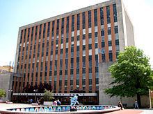
Tulsa County Court House
In 1910, Tulsa County built a court house in Tulsa on the northeast corner of Sixth Street and South Boulder Avenue. Yule marble was used in its construction. The land had previously been the site of a mansion owned by George Perryman and his wife. This was the court house where a mob of white residents gathered on May 31, 1921, threatening to lynch a young black man held in the top-floor jail. It was the beginning of the Tulsa Race Riot. See Yule marble.
An advertisement for bids specified that the building should be fireproof, built of either reinforced concrete or steel and concrete. The size was to be 120 feet (37 m) by 120 feet (37 m) with three floors and a full basement. Cost of the building was not to exceed $200,000. The jail on the top floor was not to exceed $25,000.
The building continued to serve until the present court house building (shown above) opened at 515 South Denver. The old building was then demolished and the land was then sold to private investors. The land is now the site of the Bank of America building, completed in 1967.
Geography and climate
According to the U.S. Census Bureau, the county has a total area of 587 square miles (1,520 km2), of which 570 square miles (1,500 km2) is land and 17 square miles (44 km2) (2.9%) is water.
The Arkansas River drains most of the county. Keystone Lake, formed by a dam on the Arkansas River, lies partially in the county. Bird Creek and the Caney River, tributaries of the Verdigris River drain the northern part of the county.
Adjacent counties
Demographics
As of the census of 2010, there were 603,403 people, 241,737 households, and 154,084 families residing in the county. The population density was 1,059 people per square mile (409/km²). The racial makeup of the county was 69.2% White, 10.7% Black or African American, 6.0% Native American, 2.3% Asian, 0.1% Pacific Islander, 5.8% from other races, and 5.8% from two or more races. 11.0% of the population were Hispanic or Latino of any race (8.8% Mexican). 14.2% were of German, 12.3% Irish, 8.8% English, 8.5% American, 2.3% French, and 2.3% Scottish ancestries according to the Census 2010. 88.3% spoke English, 8.1% Spanish, and 0.4% Vietnamese as their first language.
There were 241,737 households out of which 30.1% had children under the age of 18 living with them, 45.3% were married couples living together, 13.3% had a female householder with no husband present, and 36.3% were non-families. 29.60% of all households were made up of individuals and 22% had someone living alone who was 65 years of age or older. The average household size was 2.46 and the average family size was 3.07.
In the county, the population was spread out with 26.30% under the age of 18, 10.00% from 18 to 24, 30.40% from 25 to 44, 21.60% from 45 to 64, and 11.80% who were 65 years of age or older. The median age was 34 years. For every 100 females there were 94.20 males. For every 100 females age 18 and over, there were 90.90 males.
The median income for a household in the county was $47,005, and the median income for a family was $60,093. The per capita income for the county was $27,425. About 11.0% of families and 15.1% of the population were below the poverty line, including 22.6% of those under age 18 and 8.2% of those age 65 or over. Of the county's population over the age of 25, 29.2% held a bachelor's degree or higher, and 88.2% have a high school diploma or equivalent.
Politics
Tulsa, as is typical for Oklahoma, is extremely conservative for an urban county: it has voted Republican at every election since Franklin Roosevelt’s landslide in 1936. Only George Bush senior in 1992 has obtained less than a majority for the Republicans in the county since Roosevelt’s landslides, and then only because of Ross Perot’s strong candidacy – although neither Perot nor George Wallace in 1968 made as much impact here as both did in some other parts of Oklahoma.
Parks and recreation
River Parks was established in 1974 as a joint operation of the City of Tulsa and Tulsa County, with funding from both governments as well as private entities. It is not a part of the Tulsa Parks and Recreation Department, but is managed by the River Parks Authority. It is a series of linear parks that run adjacent to the Arkansas River for about 10 miles (16 km) from downtown to the Jenks bridge. Since 2007 a significant portion of the River Parks area has been renovated with new trails, landscaping and playground equipment. The River Parks Turkey Mountain Urban Wilderness Area on the west side of the Arkansas River in south Tulsa is a 300 acres (120 ha) area that contains over 45 miles (72 km) of dirt trails available for hiking, trail running, mountain biking and horseback riding. The "Tulsa Townies" organization provide bicycles that may be checked out for use. There are three kiosks in the parks where bicycles may be obtained or returned.
Towns
Census-designated places
Unincorporated communities
Former communities
NRHP sites
The following sites in Tulsa County are listed on the National Register of Historic Places: