
- elevation 548 ft (167 m) | - elevation 167 ft (51 m) | |
 | ||
Mouths Verdigris River, Oologah Lake | ||
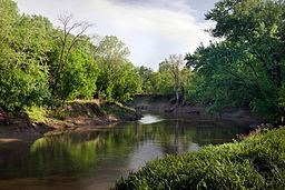
The Caney River (Lenape: Kènii Sipu ) is a 180-mile-long (290 km) river in southern Kansas and northeastern Oklahoma. The river is a tributary of the Verdigris River, and is usually a flatwater stream.
Map of Caney River, Oklahoma, USA
The Caney forms just north of the town of Grenola in Elk County, Kansas, then moves south into Oklahoma near Elgin, Kansas. It then flows south through Osage County, where it is dammed near Bowring to form Hulah Lake. Downstream of the Hulah dam, the river flows into Washington County through the center of Bartlesville, where it separates the city's downtown from its residential east side. Just south of Bartlesville, the river turns southeast and flows into Rogers County, where it joins the Verdigris River between Collinsville and Claremore.
The river is normally flat water, except when there are heavy rainstorms within the drainage area. It is popular for canoeing, both above and below Hulah Lake. However, there are almost no facilities for boaters between Wah-Sha-She State Park (near Hulah Dam) and the confluence with the Verdigris River.
The river caused disastrous floods in the Bartlesville area in 1886, 1926 and 1986.
The dam at Hulah Lake is operated by the United States Army Corps of Engineers. In October 1986 the Corps was forced to open floodgates at the dam due to above-average rainfall in the Great Plains. The resulting 500-year flood split Bartlesville virtually in half for several days and caused more than US$30 million in property damage.