Rahul Sharma (Editor)

Timeline of the 2016 Atlantic hurricane season

Updated on
Edit
Like
Comment
Share on FacebookTweet on TwitterShare on LinkedInShare on Reddit
Timeline of the 2016 Atlantic hurricane season

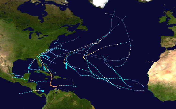
The 2016 Atlantic hurricane season was an event in the annual tropical cyclone season in the North Hemisphere. The season officially began on June 1, 2016 and ended on November 30, dates adopted by convention that historically describe the period in each year when most systems form. The season's first storm, Hurricane Alex, developed on January 13, marking the first Atlantic hurricane to exist in January since Alice in 1955 and the first to form in the month since 1938. Upon making landfall in the Azores, Alex became the first January landfalling tropical cyclone since Alice. In June, tropical storms Colin and Danielle became the earliest third and fourth named storms, respectively, on record. In August, Hermine moved ashore the coastline of Florida as a Category 1 hurricane, ending the record hurricane drought that began there after Hurricane Wilma in 2005. Late September into early October featured Hurricane Matthew, the first Category 5 Atlantic hurricane since Hurricane Felix in 2007.

Contents

This timeline includes information that was not operationally released, meaning that data from post-storm reviews by the National Hurricane Center, such as a storm that was not operationally warned upon, has been included. This timeline documents tropical cyclone formations, strengthening, weakening, landfalls, extratropical transitions, and dissipations during the season.

January

January 12

  • 18:00 UTC (2:00 p.m. AST) at 25.1°N 35.9°W / 25.1; -35.9 (Subtropical Storm Alex develops from an area of low pressure) – Subtropical Storm Alex develops from an area of low pressure about 1,150 mi (1,850 km) west-southwest of the Canary Islands.
  • January 14

  • 06:00 UTC (2:00 a.m. AST) at 29.3°N 29.6°W / 29.3; -29.6 (Subtropical Storm Alex intensifies into a Category 1 hurricane) – Subtropical Storm Alex intensifies into a Category 1 hurricane, the first to form in January since 1938 and the first to be ongoing in the month since 1955, roughly 630 mi (1,015 km) south of the Azores.
  • 12:00 UTC (8:00 a.m. AST) at 30.8°N 28.7°W / 30.8; -28.7 (Hurricane Alex attains its peak intensity) – Hurricane Alex attains its peak intensity with maximum sustained winds of 85 mph (140 km/h) and a minimum barometric pressure of 981 mb (hPa; 28.97 inHg) approximately 460 mi (740 km) south-southwest of the Azores.
  • January 15

  • 12:00 UTC (8:00 a.m. AST) at 38.0°N 27.0°W / 38.0; -27.0 (Hurricane Alex weakens to a tropical storm) – Hurricane Alex weakens to a tropical storm about 45 mi (75 km) south-southeast of Terceira Island, Azores.
  • 13:15 UTC (9:15 a.m. AST) at 38.7°N 27.1°W / 38.7; -27.1 (Tropical Storm Alex makes landfall on Terceira Island, Azores) – Tropical Storm Alex makes landfall on Terceira Island, Azores, with winds of 65 mph (100 km/h).
  • 18:00 UTC (2:00 p.m. AST) at 41.5°N 27.7°W / 41.5; -27.7 (Tropical Storm Alex transitions into an extratropical cyclone) – Tropical Storm Alex transitions into an extratropical cyclone approximately 190 mi (305 km) north of Terceira Island, Azores.
  • May

    May 27

  • 18:00 UTC (2:00 p.m. EDT) at 28.3°N 74.4°W / 28.3; -74.4 (Tropical Depression Two develops from an area of low pressure) – Tropical Depression Two develops from an area of low pressure about 205 mi (330 km) northeast of Great Abaco, Bahamas.
  • May 28

  • 12:00 UTC (8:00 a.m. EDT) at 30.0°N 78.0°W / 30.0; -78.0 (Tropical Depression Two intensifies into Tropical Storm Bonnie) – Tropical Depression Two intensifies into Tropical Storm Bonnie roughly 225 mi (360 km) south-southeast of Charleston, South Carolina.
  • 18:00 UTC (2:00 p.m. EDT) at 30.7°N 79.1°W / 30.7; -79.1 (Tropical Storm Bonnie attains its peak winds) – Tropical Storm Bonnie attains its peak intensity with maximum sustained winds of 45 mph (75 km/h) approximately 250 mi (400 km) southeast of Charleston, South Carolina.
  • May 29

  • 12:00 UTC (8:00 a.m. EDT) at 32.7°N 79.7°W / 32.7; -79.7 (Tropical Storm Bonnie weakens to a tropical depression) – Tropical Storm Bonnie weakens to a tropical depression about 15 mi (25 km) east of Charleston, South Carolina.
  • 12:30 UTC (8:30 a.m. EDT) at 32.8°N 79.8°W / 32.8; -79.8 (Tropical Depression Bonnie makes landfall with winds of 35 mph (55 km/h)) – Tropical Depression Bonnie makes landfall at Isle of Palms, South Carolina, with winds of 35 mph (55 km/h).
  • May 30

  • 12:00 UTC (8:00 a.m. EDT) at 33.3°N 79.8°W / 33.3; -79.8 (Tropical Depression Bonnie degenerates into a non-convective remnant low) – Tropical Depression Bonnie degenerates into a non-convective remnant area of low pressure roughly 125 mi (205 km) southwest of Wilmington, North Carolina.
  • June

    June 2

  • 00:00 UTC (8:00 p.m. EDT, June 1) at 34.1°N 76.0°W / 34.1; -76.0 (The remnants of Bonnie regenerate into a tropical depression) – The remnants of Bonnie regenerate into a tropical depression about 45 mi (75 km) of Cape Lookout, North Carolina.
  • June 3

  • 00:00 UTC (8:00 p.m. EDT, June 2) at 35.6°N 74.5°W / 35.6; -74.5 (Tropical Depression Bonnie attains its minimum barometric pressure) – Tropical Depression Bonnie attains a minimum barometric pressure of 1006 mbar (hPa; 29.71 inHg) roughly 65 mi (100 km) east-northeast of Cape Hatteras, North Carolina.
  • 12:00 UTC (8:00 a.m. EDT) at 35.9°N 72.6°W / 35.9; -72.6 (Tropical Depression Bonnie re-intensifies into a tropical storm) – Tropical Depression Bonnie re-intensifies into a tropical storm approximately 160 mi (260 km) east-northeast of Cape Hatteras, North Carolina.
  • June 4

  • 12:00 UTC (8:00 a.m. AST) at 35.6°N 67.3°W / 35.6; -67.3 (Tropical Storm Bonnie weakens to a tropical depression) – Tropical Storm Bonnie weakens to a tropical depression for a second time about 270 mi (435 km) northwest of Bermuda.
  • June 5

  • 00:00 UTC (8:00 p.m. AST, June 4) at 34.8°N 64.6°W / 34.8; -64.6 (Tropical Depression Bonnie degenerates into a non-convective remnant area of low pressure) – Tropical Depression Bonnie degenerates into a non-convective remnant area of low pressure for a second time roughly 175 mi (280 km) north of Bermuda.
  • 12:00 UTC (7:00 a.m. CDT) at 21.6°N 88.0°W / 21.6; -88.0 (Tropical Depression Three develops from an area of low pressure) – Tropical Depression Three develops from an area of low pressure approximately 80 mi (130 km) west-northwest of Cancún, Yucatán Peninsula.
  • 18:00 UTC (1:00 p.m. CDT) at 22.4°N 87.9°W / 22.4; -87.9 (Tropical Depression Three intensifies into Tropical Storm Colin) – Tropical Depression Three intensifies into Tropical Storm Colin about 110 mi (175 km) northwest of Cancún, Yucatán Peninsula.
  • June 7

  • 00:00 UTC (7:00 p.m. CDT, June 6) at 29.4°N 84.3°W / 29.4; -84.3 (Tropical Storm Colin attains its peak intensity) – Tropical Storm Colin attains its peak intensity with maximum sustained winds of 50 mph (85 km/h) and a minimum barometric pressure of 1001 mbar (hPa; 29.56 inHg) roughly 70 mi (110 km) south of Tallahassee, Florida.
  • 02:00 UTC (10:00 p.m. EDT, June 6) at 29.8°N 83.6°W / 29.8; -83.6 (Tropical Storm Colin makes landfall near Keaton Beach, Florida) – Tropical Storm Colin makes landfall near Keaton Beach, Florida, with winds of 50 mph (85 km/h).
  • 12:00 UTC (8:00 a.m. EDT) at 33.2°N 78.5°W / 33.2; -78.5 (Tropical Storm Colin transitions into an extratropical cyclone) – Tropical Storm Colin transitions into an extratropical cyclone approximately 75 mi (120 km) south-southwest of Wilmington, North Carolina.
  • June 19

  • 12:00 UTC (7:00 a.m. CDT) – Tropical Depression Four develops from an area of low pressure about 145 km (235 km) east-northeast of Heroica Veracruz, Mexico.
  • June 20

  • 06:00 UTC (1:00 a.m. CDT) – Tropical Depression Four intensifies into Tropical Storm Danielle roughly 70 mi (110 km) north-northeast of Heroica Veracruz, Mexico.
  • 12:00 UTC (7:00 a.m. CDT)  Tropical Storm Danielle attains its peak intensity with maximum sustained winds of 45 mph (75 km/h) and a minimum barometric pressure of 1007 mbar (hPa; 29.74 inHg) approximately 95 mi (155 km) east-southeast of Tamiahua, Mexico.
  • 22:00 UTC (5:00 p.m. CDT) – Tropical Storm Danielle makes landfall near Tamiahua, Mexico, with winds of 40 mph (65 km/h).
  • June 21

  • 00:00 UTC (7:00 p.m. CDT, June 20) – Tropical Storm Danielle weakens to a tropical depression about 25 mi (35 km) southwest of Tamiahua, Mexico.
  • 06:00 UTC (1:00 a.m. CDT) – Tropical Depression Danielle degenerates into a remnant area of low pressure roughly 85 mi (140 km) southwest of Tamiahua, Mexico.
  • July

  • No tropical cyclones form in the Atlantic Ocean during the month of July.
  • August

    August 2

  • 06:00 UTC (2:00 a.m. EDT) – Tropical Storm Earl develops from an area of low pressure about 115 mi (185 km) south of Jamaica.
  • August 3

  • 18:00 UTC (1:00 p.m. CDT) – Tropical Storm Earl intensifies into a Category 1 hurricane roughly 165 mi (265 km) east-southeast of Turneffe Atoll, Belize.
  • August 4

  • 04:00 UTC (11:00 p.m. CDT) – Hurricane Earl attains its peak intensity with maximum sustained winds of 85 mph (140 km/h) and a minimum barometric pressure of 979 mbar (hPa; 28.91 inHg) and simultaneously makes its first landfall on Turnleffe Caye, Belize.
  • 06:00 UTC (1:00 am. CDT) – Hurricane Earl makes its second landfall about 5 mi (10 km) south of Belize City, Belize, with winds of 85 mph (140 km/h).
  • 12:00 UTC (7:00 a.m. CDT) – Hurricane Earl weakens to a tropical storm about 80 mi (130 km) west of Belize City, Belize.
  • August 6

  • 02:30 UTC (9:30 p.m. CDT, August 5) – Tropical Storm Earl makes its third and final landfall about 15 mi (25 km) south-southeast of Heroica Veracruz, Mexico, with winds of 60 mph (95 km/h).
  • 12:00 UTC (7:00 a.m. CDT) – Tropical Storm Earl weakens to a tropical depression about 30 mi (50 km) northwest of Orizaba, Mexico.
  • 18:00 UTC (1:00 p.m. CDT) – Tropical Depression Earl dissipates over Central Mexico.
  • 18:00 UTC (1:00 p.m. AST) – Tropical Depression Six develops from an area of low pressure approximately 715 miles (1,150 km) west-southwest of the Cabo Verde Islands.
  • August 17
  • 12:00 UTC (8:00 a.m. AST) – Tropical Depression Six intensifies into Tropical Storm Fiona about 920 miles (1,480 km) west of the Cabo Verde Islands.
  • August 21
  • 00:00 UTC (8:00 p.m. AST August 20) – Tropical Storm Fiona attains its peak intensity with maximum sustained winds of 50 mph (85 km/h) and a minimum barometric pressure of 1004 mbar (hPa; 29.65 inHg) roughly 825 miles (1,330 km) east-northeast of the Leeward Islands.
  • August 22
  • 06:00 UTC (2:00 p.m. AST) – Tropical Storm Fiona weakens to a tropical depression approximately 770 miles (1,240 km) southeast of Bermuda.
  • 21:00 UTC (5:00 p.m. AST) – Tropical Depression Seven develops from an area of low pressure about 360 miles (580 km) west-southwest of the southernmost Cabo Verde Islands.
  • August 23
  • 03:00 UTC (11:00 p.m. AST August 22) – Tropical Depression Seven intensifies into Tropical Storm Gaston roughly 450 miles (725 km) west-southwest of the southernmost Cabo Verde Islands.
  • 12:00 UTC (8:00 a.m. AST) – Tropical Depression Fiona degenerates into a remnant low approximately 430 miles (690 km) south of Bermuda.
  • August 25
  • 04:15 UTC (12:15 a.m. AST) – Tropical Storm Gaston intensifies into a Category 1 hurricane about 1,215 miles (1,955 km) west of the Cabo Verde Islands.
  • 15:00 UTC (11:00 a.m. AST) – Hurricane Gaston weakens to a tropical storm roughly 1,160 miles (1,865 km) east-northeast of the Leeward Islands.
  • August 28
  • 03:00 UTC (11:00 p.m. AST August 27) – Tropical Storm Gaston re-intensifies into a Category 1 hurricane approximately 655 miles (1,055 km) east-southeast of Bermuda.
  • 15:00 UTC (11:00 a.m. AST) – Hurricane Gaston intensifies into a Category 2 hurricane about 600 miles (970 km) east of Bermuda.
  • 15:00 UTC (11:00 a.m. EDT) – Tropical Depression Eight develops from an area of low pressure and simultaneously attains its peak intensity with maximum sustained winds of 35 mph (55 km/h) and a minimum barometric pressure of 1009 mbar (hPa; 29.80 inHg) approximately 405 miles (655 km) southeast of Cape Hatteras, North Carolina.
  • 21:00 UTC (5:00 p.m. AST) – Hurricane Gaston intensifies into a Category 3 hurricane roughly 580 miles (935 km) east of Bermuda.
  • 21:00 UTC (5:00 p.m. EDT) – Tropical Depression Nine develops from an area of low pressure about 55 miles (90 km) northeast of Havana, Cuba.
  • August 29
  • 15:00 UTC (11:00 a.m. AST) – Hurricane Gaston weakens to a Category 2 hurricane approximately 560 miles (900 km) east of Bermuda.
  • August 31
  • 03:00 UTC (11:00 p.m. AST August 30) – Hurricane Gaston re-intensifies into a Category 3 hurricane and simultaneously attains its peak intensity with maximum sustained winds of 120 mph (195 km/h) and a minimum barometric pressure of 956 mbar (hPa; 28.23 inHg) about 1,385 miles (2,230 km) west of the Azores.
  • 18:00 UTC (1:00 p.m. CDT) – Tropical Depression Nine intensifies into Tropical Storm Hermine approximately 395 miles (640 km) south-southwest of Apalachicola, Florida.
  • 21:00 UTC (5:00 p.m. AST) – Hurricane Gaston weakens to a Category 2 hurricane for a second time roughly 1,035 miles (1,665 km) west of Faial Island, Azores.
  • September

    September 1
  • 09:00 UTC (5:00 a.m. AST) – Hurricane Gaston weakens to a Category 1 hurricane about 805 miles (1,300 km) west of Faial Island, Azores.
  • 09:00 UTC (5:00 a.m. AST) – Tropical Depression Eight dissipates approximately 405 miles (655 km) east-northeast of Cape Hatteras, North Carolina.
  • 18:55 UTC (1:55 p.m. CDT) – Tropical Storm Hermine intensifies into a Category 1 hurricane about 115 miles (185 km) south-southwest of Apalachicola, Florida.
  • September 2
  • 05:00 UTC (1:00 a.m. EDT) – Hurricane Hermine attains its peak intensity with maximum sustained winds of 80 mph (130 km/h) and a minimum barometric pressure of 982 mbar (hPa; 29.00 inHg) approximately 30 miles (50 km) south-southeast of Tallahassee, Florida.
  • 05:30 UTC (1:30 a.m. EDT) – Hurricane Hermine makes landfall about 5 miles (10 km) east-southeast of St. Marks, Florida, with winds of 80 mph (130 km/h).
  • 09:00 UTC (5:00 a.m. AST) – Hurricane Gaston weakens to a tropical storm roughly 315 miles (505 km) west of Faial Island, Azores.
  • 09:00 UTC (5:00 a.m. AST) – Hurricane Hermine weakens to a tropical storm about 20 miles (30 km) west of Valdosta, Georgia.
  • September 3
  • 06:00 UTC (2:00 a.m. AST) – Tropical Storm Gaston weakens to a tropical depression approximately 120 miles (195 km) north-northeast of Faial Island, Azores.
  • 09:00 UTC (5:00 a.m. AST) – Tropical Depression Gaston degenerates into a remnant low about 160 miles (260 km) northeast of Faial Island, Azores.
  • 15:00 UTC (11:00 a.m. EDT) – Tropical Storm Hermine degenerates into a remnant low roughly 80 miles (130 km) southeast of Norfolk, Virginia.
  • September 12
  • 15:00 UTC (11:00 a.m. AST) – Tropical Storm Ian develops from an area of low pressure approximately 1,140 miles (1,840 km) southeast of Bermuda.
  • September 14
  • 03:00 UTC (11:00 p.m. EDT September 13) – Tropical Storm Julia develops from an area of low pressure roughly 5 miles (10 km) west of Jacksonville, Florida.
  • 15:00 UTC (11:00 a.m. AST) – Tropical Depression Twelve develops from an area of low pressure approximately 95 miles (155 km) northwest of the Cabo Verde Islands.
  • September 15
  • 09:00 UTC (5:00 a.m. EDT) – Tropical Storm Julia weakens to a tropical depression about 60 miles (95 km) south-southeast of Charleston, South Carolina.
  • 21:00 UTC (5:00 p.m. EDT) – Tropical Depression Julia re-intensifies into a tropical storm and simultaneously attains its peak intensity with maximum sustained winds of 40 mph (65 km/h) and a minimum barometric pressure of 1007 mbar (hPa; 29.74 inHg) approximately 150 miles (245 km) south-southeast of Wilmington, North Carolina.
  • September 16
  • 03:00 UTC (11:00 p.m. EDT September 15) – Tropical Depression Twelve intensifies into Tropical Storm Karl roughly 575 miles (930 km) west-northwest of the Cabo Verde Islands.
  • 09:00 UTC (5:00 a.m. AST) – Tropical Storm Ian attains its peak intensity with maximum sustained winds of 60 mph (95 km/h) and a minimum barometric pressure of 994 mbar (hPa; 29.36 inHg) about 600 miles (965 km) east of Cape Race, Newfoundland.
  • 15:00 UTC (11:00 a.m. AST) – Tropical Storm Ian transitions into an extratropical cyclone roughly 795 miles (1,280 km) east-northeast of Cape Race, Newfoundland.
  • September 17
  • 03:00 UTC (11:00 p.m. EDT September 16) – Tropical Storm Julia weakens to a tropical depression for a second time approximately 275 miles (440 km) south-southeast of Cape Fear, North Carolina.
  • September 19
  • 03:00 UTC (11:00 p.m. EDT September 18) – Tropical Depression Julia degenerates into a remnant low about 110 miles (175 km) south-southeast of Myrtle Beach, South Carolina.
  • 21:00 UTC (5:00 p.m. AST) – Tropical Depression Thirteen develops from an area of low pressure roughly 350 miles (560 km) west-southwest of the Cabo Verde Islands.
  • September 20
  • 15:00 UTC (11:00 a.m. AST) – Tropical Depression Thirteen intensifies into Tropical Storm Lisa approximately 430 miles (690 km) west of the Cabo Verde Islands.
  • September 22
  • 15:00 UTC (11:00 a.m. AST) – Tropical Storm Lisa attains its peak intensity with maximum sustained winds of 50 mph (85 km/h) and a minimum barometric pressure of 999 mbar (hPa; 29.50 inHg) about 710 miles (1,145 km) west-northwest of the Cabo Verde Islands.
  • September 23
  • 21:00 UTC (5:00 p.m. AST) – Tropical Storm Lisa weakens to a tropical depression roughly 1,210 miles (1,945 km) south-southwest of the Azores.
  • September 24
  • 15:00 UTC (11:00 a.m. AST) – Tropical Depression Lisa re-intensifies into a Tropical Storm approximately 1,150 miles (1,850 km) southwest of the Azores.
  • 21:00 UTC (5:00 p.m. AST) – Tropical Storm Lisa weakens to a tropical depression for a second time about 1,150 miles (1,850 km) southwest of the Azores.
  • September 25
  • 03:00 UTC (11:00 p.m. AST September 24) – Tropical Depression Lisa degenerates into a remnant low roughly 1,165 miles (1,875 km) southwest of the Azores.
  • 09:00 UTC (5:00 a.m. AST) – Tropical Storm Karl attains its peak intensity with maximum sustained winds of 70 mph (110 km/h) and a minimum barometric pressure of 990 mbar (hPa; 29.24 inHg) approximately 635 miles (1,025 km) south of Cape Race, Newfoundland.
  • 15:00 UTC (11:00 a.m. AST) – Tropical Storm Karl transitions into an extratropical cyclone about 535 miles (865 km) south-southeast of Cape Race, Newfoundland.
  • September 28
  • 15:00 UTC (11:00 a.m. AST) – Tropical Storm Matthew develops from an area of low pressure roughly 35 miles (55 km) southeast of Saint Lucia.
  • September 29
  • 18:00 UTC (2:00 p.m. AST) – Tropical Storm Matthew intensifies into a Category 1 hurricane approximately 190 miles (300 km) northeast of Curaçao.
  • September 30
  • 05:20 UTC (1:20 a.m. AST) – Hurricane Matthew rapidly intensifies into a Category 2 hurricane about 125 miles (205 km) north of Curaçao.
  • 15:00 UTC: Hurricane Matthew rapidly intensifies to a Category 3 major hurricane.
  • 21:00 UTC: Hurricane Matthew continues to rapidly intensify and reaches Category 4 status.
  • October

    October 1
  • 03:00 UTC (11:00 p.m. AST September 30) – Hurricane Matthew intensifies into a Category 5 hurricane, attaining peak winds of 160 mph (260 km/h), about 80 miles (130 km) northwest of Punta Gallinas, Colombia.
  • 09:00 UTC (5:00 a.m. AST) – Hurricane Matthew weakens to a Category 4 hurricane approximately 365 miles (590 km) south of Port-au-Prince, Haiti.
  • 15:00 UTC (11:00 a.m. AST) – Tropical Storm Nicole develops from an area of low pressure roughly 525 mi (845 km) northeast of San Juan, Puerto Rico.
  • October 4

  • 00:00 UTC (8:00 p.m. EDT October 3) – Hurricane Matthew attains its minimum barometric pressure of 934 mb (hPa; 27.58 inHg) roughly 200 miles (325 km) southwest of Port-au-Prince, Haiti.
  • 06:00 UTC (2:00 a.m. AST) at 23.2°N 59.8°W / 23.2; -59.8 (Tropical Storm Nicole develops from an area of low pressure) – Tropical Storm Nicole develops from an area of low pressure about 530 mi (855 km) northeast of San Juan, Puerto Rico.
  • 11:00 UTC (7:00 a.m. EDT) – Hurricane Matthew makes landfall near Les Anglais, Haiti with winds of 145 mph (230 km/h).
  • October 5
  • 00:00 UTC (8:00 p.m. EDT October 4) – Hurricane Matthew makes landfall near the eastern tip of Cuba with winds of 140 mph (220 km/h).
  • 06:00 UTC (2:00 a.m. EDT) – Hurricane Matthew weakens to a Category 3 hurricane about 80 miles (130 km) west-southwest of Great Inagua Island, Bahamas.
  • October 6

  • 15:00 UTC (11:00 a.m. EDT) – Hurricane Matthew re-intensifies into a Category 4 hurricane roughly 25 miles (40 km) west-northwest of Nassau, Bahamas.
  • 18:00 UTC (2:00 p.m. AST) at 27.3°N 65.1°W / 27.3; -65.1 (Tropical Storm Nicole intensifies into a Category 1 hurricane) – Tropical Storm Nicole intensifies into a Category 1 hurricane about 345 mi (555 km) south of Bermuda.
  • October 7

  • 00:00 UTC (8:00 p.m. AST, October 6) at 27.5°N 65.2°W / 27.5; -65.2 (Hurricane Nicole intensifies into a Category 2 hurricane) – Hurricane Nicole intensifies into a Category 2 hurricane about 330 mi (530 km) south of Bermuda.
  • 06:00 UTC (2:00 a.m. EDT) – Hurricane Matthew weakens to a Category 3 hurricane for a second time approximately 80 miles (125 km) southeast of Cape Canaveral, Florida.
  • 06:00 UTC (2:00 a.m. AST) at 27.6°N 65.2°W / 27.6; -65.2 (Hurricane Nicole weakens to a Category 1 hurricane) – Hurricane Nicole weakens to a Category 1 hurricane about 320 mi (515 km) south of Bermuda.
  • 12:00 UTC (8:00 a.m. AST) at 27.6°N 65.2°W / 27.6; -65.2 (Hurricane Nicole weakens to a tropical storm) – Hurricane Nicole weakens to a tropical storm about 320 mi (515 km) south of Bermuda.
  • 21:00 UTC (5:00 p.m. EDT) – Hurricane Matthew weakens to a Category 2 hurricane about 135 miles (215 km) south of Savannah, Georgia.
  • October 8
  • 12:00 UTC (8:00 a.m. EDT) – Hurricane Matthew weakens to a Category 1 hurricane roughly 20 miles (35 km) south-southeast of Charleston, South Carolina.
  • 15:00 UTC (11:00 a.m. EDT) – Hurricane Matthew makes landfall southeast of McClellanville, South Carolina with winds of 75 mph (120 km/h).
  • October 9
  • 15:00 UTC (11:00 a.m. EDT) – Hurricane Matthew transitions into an extratropical cyclone approximately 100 miles (160 km) east of Cape Hatteras, North Carolina.
  • October 11

  • 18:00 UTC (2:00 p.m. AST) at 27.2°N 66.2°W / 27.2; -66.2 (Tropical Storm Nicole re-intensifies into a Category 1 hurricane) – Tropical Storm Nicole re-intensifies into a Category 1 hurricane about 355 mi (570 km) south-southwest of Bermuda.
  • October 12

  • 06:00 UTC (2:00 a.m. AST) at 27.6°N 66.8°W / 27.6; -66.8 (Hurricane Nicole re-intensifies into a Category 2 hurricane) – Hurricane Nicole re-intensifies into a Category 2 hurricane about 340 mi (545 km) south-southwest of Bermuda.
  • 18:00 UTC (2:00 p.m. AST) at 28.7°N 66.8°W / 28.7; -66.8 (Hurricane Nicole intensifies into a Category 3 hurricane) – Hurricane Nicole intensifies into a Category 3 hurricane about 270 mi (435 km) south of Bermuda.
  • October 13

  • 00:00 UTC (8:00 p.m. AST, October 12) at 29.6°N 66.5°W / 29.6; -66.5 (Hurricane Nicole intensifies into a Category 4 hurricane) – Hurricane Nicole intensifies into a Category 4 hurricane about 205 mi (330 km) south-southwest of Bermuda.
  • 06:00 UTC (2:00 a.m. AST) at 30.6°N 66.2°W / 30.6; -66.2 (Hurricane Nicole attains its peak intensity) – Hurricane Nicole attains its peak intensity with maximum sustained winds of 140 mph (220 km/h) and a minimum barometric pressure of 950 mbar (hPa; 28.06 inHg) about 135 mi (215 km) south-southwest of Bermuda.
  • 12:00 UTC (8:00 a.m. AST) at 31.6°N 65.3°W / 31.6; -65.3 (Hurricane Nicole weakens to a Category 3 hurricane) – Hurricane Nicole weakens to a Category 3 hurricane about 50 mi (85 km) south-southwest of Bermuda.
  • 18:00 UTC (2:00 p.m. AST) at 33.0°N 63.9°W / 33.0; -63.9 (Hurricane Nicole weakens to a Category 2 hurricane) – Hurricane Nicole weakens to a Category 2 hurricane about 65 mi (100 km) northeast of Bermuda.
  • October 14

  • 06:00 UTC (2:00 a.m. AST) at 34.9°N 60.5°W / 34.9; -60.5 (Hurricane Nicole weakens to a Category 1 hurricane) – Hurricane Nicole weakens to a Category 1 hurricane about 300 mi (485 km) northeast of Bermuda.
  • October 18

  • 00:00 UTC (8:00 p.m. AST, October 17) at 43.5°N 41.9°W / 43.5; -41.9 (Hurricane Nicole weakens to a tropical storm) – Hurricane Nicole weakens to a tropical storm about 620 mi (1,000 km) west-northwest of the Azores.
  • 12:00 UTC (8:00 a.m. AST) at 49.0°N 38.5°W / 49.0; -38.5 (Tropical Storm Nicole transitions into an extratropical cyclone) – Tropical Storm Nicole transitions into an extratropical cyclone about 755 mi (1,215 km) northwest of the Azores.
  • November

    November 20

  • 18:00 UTC (1:00 p.m. EST) at 11.1°N 79.7°W / 11.1; -79.7 (Tropical Depression Sixteen develops from an area of low pressure) – Tropical Depression Sixteen develops from an area of low pressure about 120 mi (195 km) north of Colón, Panama.
  • November 21

  • 06:00 UTC (1:00 a.m. EST) at 11.3°N 79.3°W / 11.3; -79.3 (Tropical Depression Sixteen intensifies into Tropical Storm Otto) – Tropical Depression Sixteen intensifies into Tropical Storm Otto roughly 145 mi (235 km) north-northeast of Colón, Panama.
  • November 23

  • 18:00 UTC (1:00 p.m. EST) at 11.2°N 81.1°W / 11.2; -81.1 (Tropical Storm Otto intensifies into a Category 1 hurricane) – Tropical Storm Otto intensifies into a Category 1 hurricane approximately 155 mi (250 km) northwest of Colón, Panama.
  • November 24

  • 06:00 UTC (1:00 a.m. EST) at 11.1°N 82.4°W / 11.1; -82.4 (Hurricane Otto intensifies into a Category 2 hurricane) – Hurricane Otto intensifies into a Category 2 hurricane about 90 mi (150 km) east of the Costa Rica–Nicaragua border.
  • 12:00 UTC (7:00 a.m. EST) at 11.0°N 83.0°W / 11.0; -83.0 (Hurricane Otto intensifies into a Category 3 hurricane and attains its peak intensity) – Hurricane Otto intensifies into a Category 3 hurricane and simultaneously attains its peak intensity with maximum sustained winds of 115 mph (185 km/h) and a minimum barometric pressure of 975 mb (hPa; 28.80 inHg) roughly 45 mi (75 km) east of the Costa Rica–Nicaragua border.
  • 17:30 UTC (12:30 p.m. EST) at 11.0°N 83.8°W / 11.0; -83.8 (Hurricane Otto makes landfall) – Hurricane Otto makes landfall approximately 10 mi (15 km) northwest of the Costa Rica–Nicaragua border, with winds of 115 mph (185 km/h).
  • 18:00 UTC (1:00 p.m. EST) at 11.0°N 83.9°W / 11.0; -83.9 (Hurricane Otto weakens to a Category 2 hurricane) – Hurricane Otto weakens to a Category 2 hurricane about 15 mi (25 km) northwest of the Costa Rica–Nicaragua border.
  • November 25

  • 00:00 UTC (7:00 p.m. EST, November 24) at 10.9°N 84.9°W / 10.9; -84.9 (Hurricane Otto weakens to a Category 1 hurricane) – Hurricane Otto weakens to a Category 1 hurricane roughly 40 mi (65 km) northeast of Liberia, Costa Rica.
  • 03:30 UTC (9:30 p.m. CST, November 24) at 10.7°N 85.6°W / 10.7; -85.6 (Hurricane Otto weakens to a tropical storm and enters the East Pacific) – Hurricane Otto weakens to a tropical storm as it enters the East Pacific basin.
  • November 30

  • The 2016 Atlantic hurricane season officially ends.
  • References

    Timeline of the 2016 Atlantic hurricane season Wikipedia