
Surface elevation 638 m Length 36.05 km Shore length 206 km | Catchment area 5,830 mi² (15,099 km²) Max. length 22.4 mi (35.8 km) Area 86.98 km² Width 3.2 km | |
 | ||
Primary inflows | ||
Fishing trip at theodore roosevelt lake arizona
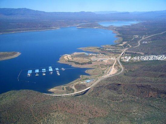
Theodore Roosevelt Lake (usually called Roosevelt Lake, sometimes Lake Roosevelt) is a large reservoir formed by Theodore Roosevelt Dam on the Salt River in Arizona as part of the Salt River Project (SRP). Located roughly 80 miles (130 km) northeast of Phoenix in the Salt River Valley, Theodore Roosevelt is the largest lake or reservoir located entirely within the state of Arizona (Lake Mead and Lake Powell are larger but both are located partially within the neighboring states of Nevada and Utah respectively). Both the reservoir and the masonry dam that created it, Roosevelt Dam, were named for U.S. President Theodore Roosevelt who dedicated the dam himself in March 1911. Roosevelt Lake is a popular recreation destination within the Tonto National Forest, as such the facilities located at this lake are managed by that authority.
Contents
- Fishing trip at theodore roosevelt lake arizona
- Map of Theodore Roosevelt Lake Arizona USA
- GeographyEdit
- Recreation and wildlifeEdit
- References
Map of Theodore Roosevelt Lake, Arizona, USA
Roosevelt Lake is the oldest of the six reservoirs constructed and operated by the Salt River Project. It also has the largest storage capacity of the SRP lakes with the ability to store 1,653,043 acre feet (2.039 km3) of water when the conservation limit of Roosevelt Dam is reached. When the dam is in flood-control mode, the lake can store 2,910,200 acre·ft (3.590 km3) of water; however, the U.S. Army Corps of Engineers requires all water over the conservation limit to be released from the lake within 20 days.
GeographyEdit
Roosevelt Lake is located in central Arizona almost entirely within Gila County although a small portion lies in Maricopa County. Located about 4 miles (6 km) upstream from Apache Lake (the next SRP reservoir on the Salt River), Roosevelt Lake occupies about 10 miles (16 km) of the original Salt River riverbed and also extends for about 8 miles (13 km) up Tonto Creek, a significant tributary of the Salt with its headwaters along the Mogollon Rim. The lake covers much of the southern portion of the Tonto Basin, a low-lying area between the Sierra Ancha Mountains, Mazatzal Mountains (including Four Peaks), and the Superstition Mountains. State Route 188 travels along the shore of the lake for much of its length. Tonto National Monument is located 4 miles (6 km) from Roosevelt Dam, parts of the monument provide views of much of the reservoir.
Recreation and wildlifeEdit
Fishing is a common recreational activity at Roosevelt Lake. The lake is home to a variety of game fish including crappie, carp, sunfish, flathead and channel catfish, and smallmouth bass and largemouth bass. There is a slot size limit for the bass. Only one bass can be taken per day measuring between 13 and 16 inches.
Until recently, it also hosted the state's most significant population of the federally endangered southwestern willow flycatcher. Since the lake's rise following heavy rains in the winter of 2005, the population dynamics between this site and the other significant Arizona population (on the San Pedro River) are unclear.
There are several Arizona Trail trailheads in the vicinity. The 800 mile (1,280 km) long hiking trail extending from the Arizona-Mexico border to Utah crosses the Salt River on the State Route 188 bridge that crosses Theodore Roosevelt Lake just northeast of Roosevelt Dam.