
Governing body U.S. Forest Service Nearest city Apache Junction | Area 646.5 km² Country United States of America Established 1939 | |
 | ||
Similar Lost Dutchman State Park, Apache Trail, Weavers Needle, Goldfield (Ghost Town), Salt River | ||
Haunted canyon superstition mountains
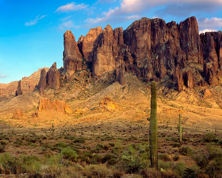
The Superstition Mountains (Yavapai: Wi:kchsawa), popularly called "The Superstitions", is a range of mountains in Arizona located to the east of the Phoenix metropolitan area. They are anchored by Superstition Mountain, a large mountain that is a popular recreation destination for residents of the Phoenix, Arizona area.
Contents
- Haunted canyon superstition mountains
- Map of Superstition Mountains Arizona 85119 USA
- Superstition mountains arizona tonto national forest need saving
- Superstition legends
- Nearby towns and cities
- References
Map of Superstition Mountains, Arizona 85119, USA
The mountain range is in the federally designated Superstition Wilderness Area, and includes a variety of natural features in addition to its namesake mountain. Weavers Needle, a prominent landmark and rock climbing destination set behind and to the east of Superstition Mountain, is a tall eroded volcanic remnant that plays a significant role in the legend of the Lost Dutchman's Gold Mine. Peralta Canyon, on the northeast side of Superstition Mountain, contains a popular trail that leads up to Fremont Saddle, which provides a very picturesque view of Weavers Needle. Miner's Needle is another prominent formation in the wilderness and a popular hiking destination.
As with most of the terrain surrounding the Phoenix metropolitan area, the Superstition Mountains have a desert climate, with high summer temperatures and a handful of perennial sources of water. The elevation in the more remote, eastern portion of the wilderness is higher than the western portion, which lowers temperatures slightly. Numerous hiking trails cross the mountains from multiple access points, including the Peralta Trailhead, the most popular. The Lost Dutchman State Park, located on the west side of Superstition Mountain, includes several short walking trails.
The Superstition Mountains are bounded roughly by U.S. Route 60 on the south, State Route 88 on the northwest, and State Route 188 on the northeast.
The mountains were once known in Spanish as Sierra de la Espuma.
The Superstition Mountains have a maximum elevation of 6,266 ft (1,910 m) and prominence of 1,706 ft (520 m) at Mound Mountain in the far eastern section of the range.
Superstition mountains arizona tonto national forest need saving
Superstition legends
The legend of the Lost Dutchman's Gold Mine centers around the Superstition Mountains. According to the legend, a German immigrant named Jacob Waltz discovered a mother lode of gold in the Superstition Wilderness and revealed its location on his deathbed in Phoenix in 1891 to Julia Thomas, a boarding-house owner who had taken care of him for many years. Several mines have been claimed to be the actual mine that Waltz discovered, but none of those claims have been verified. The legends and lore of the Superstition Mountains can be experienced at the Superstition Mountain Museum on the Apache Trail where artifacts of the Lost Dutchman are on display.
Some Apaches believe that the hole leading down into the lower world, or hell, is located in the Superstition Mountains. Winds blowing from the hole is supposed to be the cause of severe dust storms in the metropolitan region.