
Chapman code STI | ||
 | ||
Stirlingshire argyll
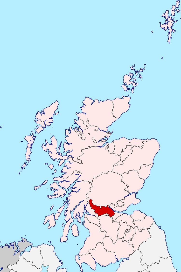
Stirlingshire or the County of Stirling (Scots: Coontie o Stirlin, Scottish Gaelic: Siorrachd Sruighlea) is a historic county and registration county of Scotland, based in Stirling, the county town. See Registers of Scotland, Land Register Counties.
Contents
- Stirlingshire argyll
- East kilbride v east stirlingshire
- Coat of arms
- History
- Civil parishes
- Burghs
- Towns and villages
- Local Government
- Parliamentary constituencies
- 1707 1918
- 1918 1975
- List of listed buildings
- References
It borders Perthshire to the north, Clackmannanshire and West Lothian to the east, Lanarkshire to the south, and Dunbartonshire to the south-west.
Stirling and Falkirk are still covered by the same lieutenancy area.
Until the 1890s the county had two small exclaves: part of the parish of Logie, which was surrounded by Perthshire, and the parish of Alva, locally in Clackmannanshire. The Perthshire part of Logie was added to Stirlingshire, while Alva was annexed by Clackmannanshire.
East kilbride v east stirlingshire
Coat of arms
The County Council of Stirling was granted a coat of arms by Lord Lyon King of Arms on 29 September 1890.
The design of the arms commemorated the Scottish victory at the Battle of Bannockburn in the county.
On the silver saltire on blue of St Andrew was placed the rampant red lion from the royal arms of Scotland.
Around this were placed two caltraps and two spur-rowels recalling the use of the weapons against the English cavalry.
On the abolition of the Local Government council in 1975, the arms were regranted to the Local Government Stirling District Council.
They were regranted a second time in 1996 to the present Local Government Stirling Council, with the addition of supporters (a goshawk and a wolf).
History
In 1130 Stirling, one of the principal royal strongholds of the Kingdom of Scotland, was created a Royal burgh by King David I.
On 11 September 1297, the forces of Andrew Moray and William Wallace defeated the combined English forces of John de Warenne, 6th Earl of Surrey, and Hugh de Cressingham near Stirling, on the River Forth, at the Battle of Stirling Bridge during the First War of Scottish Independence.
On 22 July 1298 the Battle of Falkirk saw the defeat of William Wallace by King Edward I of England.
In 1314 the Battle of Bannockburn, Bannockburn, (Blàr Allt a' Bhonnaich in Scottish Gaelic) (24 June 1314) was a significant Scottish victory in the Wars of Scottish Independence. It was one of the decisive battles of the First War of Scottish Independence.
On 11 June 1488 the Battle of Sauchieburn was fought at the side of Sauchie Burn, a stream about two miles south of Stirling, Stirlingshire, Scotland. The battle was fought between the followers of King James III of Scotland and a large group of rebellious Scottish nobles including Alexander Home, 1st Lord Home, nominally led by the king's 15-year-old son, Prince James, Duke of Rothesay (reigned 1488-1513).
In 1645 the Covenanter army under General William Baillie formed near Banton for their engagement with the Royalist forces under the command of Montrose at the Battle of Kilsyth, Kilsyth, on August 15, 1645; a major battle of the Wars of the Three Kingdoms.
On 17 January 1746 the Battle of Falkirk Muir saw the Jacobites under Charles Edward Stuart defeat a government army commanded by Lieutenant General Henry Hawley.
Civil parishes
In 2001, according to the website of the General Register Office for Scotland, there were 871 civil parishes. List of civil parishes in Scotland
Civil parishes are still used for some statistical purposes, and separate census figures are published for them. As their areas have been largely unchanged since the 19th century this allows for comparison of population figures over an extended period of time.
Following the boundary changes caused by the Local Government (Scotland) Act 1889, Stirlingshire contained the following civil parishes:
Burghs
In 1930 Falkirk and Stirling became large burghs, taking over some of the duties of the county council. The remaining four burghs became "small burghs", with limited powers.
Towns and villages
Some Stirlingshire towns listed in the Registers of Scotland, Land Register Counties.
Local Government
In 1894 parish Local Government councils were established for the civil parishes, replacing the previous parochial boards.
The Local Government parish councils were in turn superseded by Local Government district councils in 1930.
In 1930 the parishes ceased to be used for local government purposes, and the landward area of the county (the part outside the burghs) was divided into eight Local Government districts. These Local Government districts were abolished in 1975.
In 1975 most of Stirlingshire was included in the Local Government Central Region, with Kilsyth and surrounding area becoming part of the Local Government Strathclyde Region.
Since 1996 the area has been part of the Local Government council areas of :
Parliamentary constituencies
Following the Act of Union, Stirlingshire returned members to the House of Commons of the Parliament of the United Kingdom from 1708.
1707 - 1918
1918 - 1975
In 1918 seats in the House of Commons were redistributed. Stirlingshire was thereafter represented by three members of parliament.
These boundaries continued in use until 1983, when new constituencies were formed based on the Local Government regions and districts created in 1975.
List of listed buildings
List of listed buildings in Logie, Stirling