
Population 6,762 (UK census 2011) Civil parish Logie Sovereign state United Kingdom Local time Friday 10:35 AM Dialling code 01786 | OS grid reference NS794974 Post town STIRLING | |
 | ||
Weather 2°C, Wind E at 6 km/h, 90% Humidity Lieutenancy areas | ||
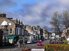
Bridge of Allan (Scots: Brig Allan, Scottish Gaelic: Drochaid Alain) is a town in the Stirling council area in Scotland, just north of the city of Stirling. It was formerly administered by firstly Stirlingshire County Council and then Central Regional Council.
Contents
- Map of Bridge of Allan UK
- Haverstock self catering bridge of allan self catering stirling wedding accommodation
- Strathallan Games
- Churches
- Notable residents
- Facilities in Bridge of Allan
- References
Map of Bridge of Allan, UK
It lies on the Allan Water, a northern tributary of the River Forth, built largely on the well-wooded slopes of the Westerton and Airthrey estates, sheltered by the Ochil Hills from the north and east winds. Most of the town is to the east of the river; the bridge is part of the A9, Scotland's longest road, while the railway line and the M9 pass to the west of the river.
Bridge of Allan railway station is on the Edinburgh to Dunblane Line.
During the Iron Age the local people of the area were known as the Maeatae and it was they who constructed a powerful hillfort nearby. The early village consisted of seven small clachans: Bridge End, Kierfield, Old Lecropt, Pathfoot, Logie, Corntown and the Milne of Airthrey. The villages were very separate and the villagers lived in the small world of their own communities.
The site occupied by modern Bridge of Allan stretches from the clachan of Logie across the Allan Water to the University of Stirling. It was first mentioned in a charter granted by King David I. The charter was written in connection with a dispute between the nuns of North Berwick and the monks at Dunfermline Abbey over the tithes of Airthrey and Corntown. It is undated, but had been granted by 1146.
A hog's back, narrow, stone bridge was built to replace the old ford across the River Allan in 1520. It rose sharply from the riverbank and dipped steeply at the other side. Soon after a few cottages began to appear around the ends of the bridge and an embryonic Bridge of Allan slowly formed. In the woods above the bridge a mine opened. This was worked from around 1550, and quantities of copper, silver and gold were extracted.
By the middle of the seventeenth century the Airthrey Estate had passed to relatives of the Marquess of Montrose, the Grahams. James Graham rose for the king during the English civil war, and in 1645 as the army of the Duke of Argyll passed through the Airthrey estate on its way to the battle of Kilsyth they burned down the manor house.
The Jacobites were in Bridge of Allan in 1745, where three hundred highlanders set up a roadblock on the bridge and charged a toll for its passage.
Major Alexander Henderson, the Laird of Westerton, drew up plans of how he wanted the village to be laid out in 1850. The plan envisaged spacious streets with pleasure grounds in the woods. He also erected a fountain in Market Street. It was at this time that many handsome stone villas were built on wide thoroughfares, with practically every second house becoming a lodging house as Bridge of Allan became a renowned spa town, especially during the boom years of hydropathic establishments. Among the visitors was Robert Louis Stevenson who visited annually during his youth.
The Museum Hall was built by the trustees of John Macfarlane in 1887, originally as the Macfarlane Museum and Art Gallery. In its use as a concert venue it once played host to the Beatles but was subsequently allowed to fall into disuse and considerable disrepair. It has now been redeveloped for residential use.
Haverstock self catering bridge of allan self catering stirling wedding accommodation
Strathallan Games
The Sunday following the first Saturday in August is usually the date for the Strathallan Games. Founded in 1852 by Major Henderson, the games attract hundreds of athletes, pipe bands and highland dancers.
Churches
There are two churches in the village, which face one another at the junction of Keir Street and Fountain Road. The Scottish Episcopal congregation meet at St Saviour's Church, built in 1857. Facing St Saviour's is Bridge of Allan Parish Church, the local Church of Scotland. This congregation was formed by the union of two Church of Scotland congregations in 2004, when Chalmers Church - located on the village's main street, Henderson Street - closed. Bridge of Allan Parish Church is notable for some of its internal fittings, which were designed by Charles Rennie Mackintosh in 1904.
Also outside Bridge of Allan, on the A9 road to Dunblane, is Lecropt Kirk (Church of Scotland). Historically this church served the entirely rural parish of Lecropt, west of Bridge of Allan.