
Highest point Platte Mountains Platte, Teichelberg | ||
 | ||
The Steinwald is a mountain range up to 946 m above sea level (NN) in southern Germany and, at the same time, a nature park (Steinwald Nature Park) founded in 1970 with an area of 246 square kilometres (95 sq mi) in the province of Upper Palatinate, in North Bavaria.
Contents
- Map of Steinwald 95679 Waldershof Germany
- Geographical location
- Mountains and hills
- Geology
- Climate
- Nature
- Forest damage
- Walking
- Maps
- References
Map of Steinwald, 95679 Waldershof, Germany
Geographical location
The Steinwald lies south of the Upper Franconian county town of Marktredwitz and north of Erbendorf in the district of Tirschenreuth. The Steinwald is separated from the Fichtelgebirge to the northwest by the Waldershof trough (Waldershofer Senke) and from the Upper Palatine Forest to the southeast by the Waldnaab-Wondreb-trough.
Mountains and hills
The mountains and hills in the range and in the Steinwald Nature Park include the following − in order of height in metres (m) above sea level (NN):
Geology
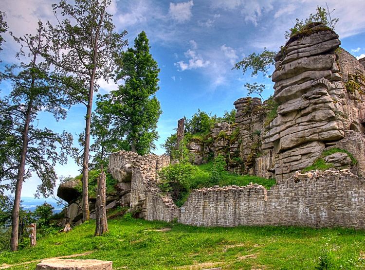
Like the Fichtelgebirge, the Steinwald consists mainly of granite. In the south and east it is surrounded by a basalt landscape of Kuppen - gentle, rounded summits - (Kemnather Land, Nördlicher Steinwald), whose most striking elevations are the Parkstein near Weiden, the Rauhe Kulm near Kemnath, the Schlossberg near Waldeck, the Armesberg, the Teichelberg and the Ruheberg. Numerous granite blocks and rock 'bastions' are found in the Steinwald, often with fantastic shapes. They have odd names such as Katzentrögel, Zipfeltannenfelsen oder Saubadfelsen.
The Steinwald is still rich in precious stones, including for example agate and jasper, ore and rock types. Ores such as siderite, limonite and haematite occur too. These ores used to be mined, especially in the Middle Ages; today the remaining supplies are too small and too scattered to enable them to be extracted profitably.
The Steinwald is frequently seen as an extension of the Fichtelgebirge mountains. But geological investigations have proved this to be wrong; the granite in the Steinwald is considerably softer than the Fichtelgebirge granite and, unlike the latter, contains no lithium. In addition it is younger than the Fichtelgebirge, as evinced by the numerous deposits of basalt and chalk. The Steinwald is also rich in springs. Water often bubbles out of rock crevices and has a good quality. It also has one of the most iron-rich springs in the whole of the Europe, the King Otto Spring in King-Otto-Bad near Wiesau, which is named after the brother of the Prince Regent Luitpold of Bavaria, Otto I of Greece. Even today the water is bottled by the firm of King-Otto-Sprudel.
The soil quality in the Steinwald depends on the dominant rock locally. Its extremely varied soils can be divided into about four types:
Climate
The climate in the Steinwald has Alpine characteristics. It is not snow-free until the middle of May. Giant snowdrifts and severe snow storms render paths and trails impassable in winter. A short spring follows the long and harsh winter; summer has more precipitation and is followed by a mild and fine autumm. Average annual temperatures lie between 4 and 5 °C, average precipitation is about 15 cm.
Nature
The woods of the Steinwald consist mainly of conifers, with spruce as the dominant species. The proportion of deciduous trees has risen, however, from 25.1% in 1987 to 30.4% in 2002. Berry bushes provide much of the ground cover, especially blueberries and cranberries, and cryptogams - lichens and mosses - are widespread. The seven-petalled Arctic starflower, the symbol of the Fichtelgebirge Club, occurs here and ferns also abound in the woods.
Wild animals in the Steinwald, such as the red deer, wild boar, red fox, weasel, polecat, stoat and, more recently, the lynx, are almost only found in the more remote areas of woodland. Woodpeckers, goshawks, eagle-owls, tawny owls live in the high treetops, as do pygmy owls and the Tengmalm's owl. Enjoying special projection birds that would otherwise become rare such as the black storks and the capercaillie, which still occur in low numbers in the Steinwald.
Forest damage
The forest is exposed to many dangers. Chief among the concerns of forest owners and foresters is the almost annual weather damage:
Dealing with damaged areas of the forest ties up a lot of effort and means that sometimes long-term forestry work suffers. On the other hand, the heavily thinned areas of forest result in a rapid transformation that helps to prevent attack by bark beetle.
For a good 20 years new forms of forest damage have appeared in the High Steinwald that go under the name of Waldsterben or forest dieback. Today the Steinwald in Northeast Bavaria is one of the main areas of concern. This is due to the high levels of sulphur dioxide emission from the burning of brown coal in the nearby Eger Basin, to acid rain and to the many days of mist and fog. The forest damage, which is clearly visible, has remained since 1986 at about the same level of 32%. Research to date has shown that its causes are complex and involve biotic and abiotic factors, however environmental pollution plays a significant role. Forestry management measures include fertilising in order to counteract the lack of magnesium which causing a yellowing of the pine needles. So that no treeless steppes appear as on the heights of the Ore Mountains, the damaged highlands are planted. The Kemnath Forestry Department has done this on about 200 hectares (490 acres).
Walking
Many holidaymakers visit the Steinwald to go walking. The long-distance trails through the Steinwald are:
From the walker's car park north of Pfaben an educational trail leads to some of the natural attractions of the Steinwald. In addition, there are circular walks starting from Friedenfels and Erbendorf. The High Steinwald may be reached on trails running from Neusorg, Waldershof, Marktredwitz, Poppenreuth, Fuchsmühl, Friedenfels and Erbendorf.