
Admin. region Upper Palatinate Elevation 397 m (1,302 ft) Population 42,219 (31 Dec 2008) Local time Sunday 9:29 PM | District Urban district Time zone CET/CEST (UTC+1/+2) Postal code 92637 | |
 | ||
Weather 14°C, Wind SE at 5 km/h, 60% Humidity Points of interest Internationales Keramik‑Museum Weiden, Eisenbahnmuseum, Herzer Wolfgang, Unteres Tor | ||
Best places to visit
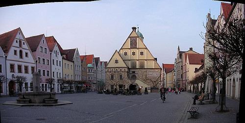
Weiden in der Oberpfalz (official name: Weiden i.d.OPf.) is a district-free city in Bavaria, Germany. It is located 100 km east of Nuremberg and 35 km west of the Czech border. A branch of the German Army is located here.
Contents
- Best places to visit
- Map of Weiden Germany
- History
- Districts
- Incorporations into Weiden in der Oberpfalz
- Historical buildings
- Museums
- Twinnings
- Climate
- People
- References
Map of Weiden, Germany
History
Weiden in der Oberpfalz was first mentioned in a document in 1241 as Weiden. It is assumed that the first settlements in Weiden are dated the year 1000. Located at the intersection of two major trading routes (Goldene Strasse and Magdeburger Strasse) Weiden soon became an important trading center with a population of 2,200 in 1531. An economic boom came along in 1863 when Weiden was connected to the railroad network. Some major companies of the glass and china industry settled in Weiden and the population increased.
Districts
Incorporations into Weiden in der Oberpfalz
Historical buildings
Museums
Twinnings
Climate
This area is characterized by equable climates with few extremes of temperature and ample precipitation in all months. The Köppen Climate Classification subtype for this climate is "Cfb". (Marine West Coast Climate).