
 | ||
Website regierung.oberpfalz.bayern.de Population 1.085 million (30 Jun 2008) Points of interest The Walhalla, Old Stone Bridge, Regensburg Museum of History, Regensburg Museum of Danube, Regensburg Cathedral Colleges and Universities University of Applied Sciences, University of Regensburg, Regensburg University of Applie, College of Catholic Church M | ||
Die bayernhymne
The Upper Palatinate (German: Oberpfalz) is one of the seven administrative districts of Bavaria, Germany, located in the east of Bavaria.
Contents
- Die bayernhymne
- Map of Upper Palatinate Germany
- Best places to visit
- Main sights
- History
- Population
- References
Map of Upper Palatinate, Germany
Best places to visit
Main sights
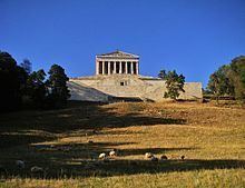
Major tourist attractions include the former ducal residences Regensburg with the Walhalla nearby and Amberg, the city of Weiden and Waldsassen Abbey. Scenic attractions include the river Danube and the Upper Palatine Forest.
History
At the beginning of the High Middle Ages the region now known as the Upper Palatinate was part of the Bavarian March of the Nordgau. The region took its current name no earlier than the early 14th century.
From the mid 13th century much of the region was controlled by the Wittelsbach dynasty and until 1329 was ruled by the Wittelsbach Elector Palatine as part of the larger County Palatine of the Rhine (German: Pfalzgrafschaft bei Rhein). By the 1329 Treaty of Pavia, the Wittelsbach territories were divided between two branches of the dynasty. The territory around the Rhine river in the west became known as the Rhenish Palatinate (German: Rheinpfalz) or Lower Palatinate, and is today usually known simply as the Palatinate (German: Pfalz); it is from this territory that the modern German state of Rhineland-Palatine derives its name. By contrast, the territory to the east centred Amberg became known as the Upper Palatinate (German: Oberpfalz), upper and lower in this case referring to the elevation of the territories (compare Low and High German, Upper and Lower Lusatia, Upper and Lower Lorraine, Low Countries, Lower Saxony).
Cadet branches of the Wittelsbach dynasty also ruled over smaller territories in Neuburg and Sulzbach. As a result of the Elector Palatine Frederick V's abortive claim to the Bohemian throne in 1619–1620, the Upper Palatinate, along with the rest of his lands, were declared forfeit to the Emperor and, along with the Electoral title, given to the Duke of Bavaria. Although the Lower Palatinate was restored to Frederick's son by the Peace of Westphalia in 1648, the Upper Palatinate remained under the Elector of Bavaria, and has remained a part of Bavaria ever since. The smaller territories of Sulzbach and Neuburg came to Bavaria in 1777 when Charles Theodore, Elector of Bavaria inherited the Bavarian lands of his Wittelsbach cousin Maximilian III Joseph, Elector of Bavaria. The city of Regensburg, an Imperial Free City, was not joined with the rest of the region until the end of the Holy Roman Empire in 1806 and the end of the short-lived Principality of Regensburg under Carl von Dalberg, which existed from 1803 to 1810.
After the founding of the Kingdom of Bavaria the state was totally reorganised and, in 1808, divided into 15 administrative districts (German: Regierungsbezirke; singular Regierungsbezirk), in Bavaria called Kreise (literally "Circles", singular: Kreis). They were created in the fashion of the French departments, quite even in size and population, and named after their main rivers. In the following years, due to territorial changes (e.g. the loss of Tyrol, the addition of the Palatinate), the number of Kreise in the kingdom was reduced to 8. One of these was the Regenkreis (Regen District). In 1837 king Ludwig I of Bavaria renamed the Kreise after historical territorial names and tribes of the area. This also involved some border changes or territorial swaps. Thus the district name of Regenkreis changed to Upper Palatinate.
The development of railroads in the area is covered in the book Eisenbahn in der Oberpfalz.
Population
Historical Population of Upper Palatinate: