
Population 3,325 (2013 est) Area 6,716 km² | Established 1890 Founded 1890 Mayor Shane Love | |
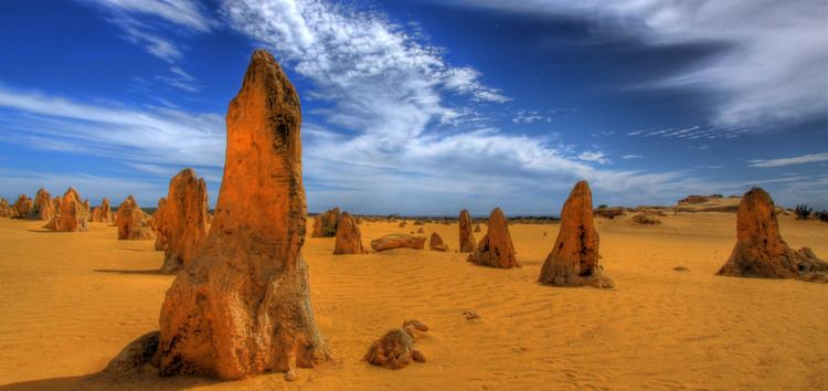 | ||
Points of interest The Pinnacles, Nambung National Park, Lesueur National Park, Lake Thetis, Hangover Bay Destinations Jurien Bay, Cervantes, Nambung National Park, Nambung, Lesueur National Park | ||
The Shire of Dandaragan is a local government area located in the Wheatbelt region of Western Australia, about 200 kilometres (124 mi) north of the state capital, Perth. The Shire covers an area of 6,716 square kilometres (2,593 sq mi) and its seat of government is the town of Jurien Bay.
Contents
Map of Dandaragan, WA, Australia
History
On 27 February 1890, the Dandaragan Road District was created. On 1 July 1961, it became a shire following the enactment of the Local Government Act 1960. Until the late 1960s it was a sparsely populated agricultural shire, but the coastal towns of Jurien Bay and Cervantes and the popularity of The Pinnacles Desert with tourists have helped to fuel the Shire's growth. Originally the Shire's main administration centre was in the small town of Dandaragan, however due to the disproportionate population growth in the town of Jurien Bay the administration was relocated there in 2003.
Wards
On 22 May 1971, the shire was divided into Coastal, Central, North and South wards, and its representation increased from seven to nine councillors. Over time, the Coastal ward increased in size, and ultimately on 2 May 1987, the ward was abolished and two new wards, Cervantes and Jurien, were created. By 3 November 1989, the following wards existed:
On 7 May 2005, the shire was redivided into two wards:
By the 2009 Council elections all wards had been abolished and nine councillors represent the whole shire.