
Population 8,770 (2006 census) Area 1,922 km² | Established 1880 Shire of Boonah Beaudesert Founded 1880 | |
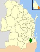 | ||
The Shire of Boonah was a local government area in South East Queensland, Australia, about 80 kilometres (50 mi) southwest of Brisbane. The shire covered an area of 1,921.6 square kilometres (741.9 sq mi), and existed from 1880 until its merger with parts of the Shire of Beaudesert and City of Ipswich to form the Scenic Rim Region on 15 March 2008.
Contents
- History
- Greater Ipswich Scheme of 1949
- Amalgamations in 2000
- Amalgamations of 2008
- Towns and localities
- Population
- Chairmen and mayors
- References
The shire was part of the "Scenic Rim", a group of mountain ranges forming part of the Great Dividing Range, and contained four national parks—Main Range, Mount French, Moogerah Peaks and Mount Greville National Park which is now part of Moogerah Peaks National Park.
History
The Goolman Division was incorporated on 11 November 1879 under the Divisional Boards Act 1879 with a population of 1542. It was centred on Boonah and its board consisting of six councillors. On 4 January 1884, there was an adjustment of boundaries between No. 2 subdivision of Mutdapilly Division and subdivision No. 2 of the Goolman Division. Initially, the Goolman Division had its office in Flinders (27°46′59″S 152°42′59″E). However, in 1887, the railway line from Ipswich was extended to Boonah, and the Goolman Division office moved to Boonah.
On 25 October 1890, part of the northern section of Goolman Division became part of the new Normanby Division. With the passage of the Local Authorities Act 1902, Goolman Division became the Shire of Goolman on 31 March 1903. The Shire offices were in High Street, Boonah. The Goolman Shire War Memorial was unveiled in Boonah (then part of the Goolman Shire) on 19 May 1920 by General Birdwood and Councillor Alexander John Tait McKay. It is generally known as the Boonah War Memorial. On 14 October 1937 was renamed Shire of Boonah, which apparently means "bloodwood tree" in the local Aboriginal language.
Greater Ipswich Scheme of 1949
On 29 January 1949, a new Local Government Act was enacted to further amalgamate local government in the Ipswich area, abolishing the Shires of Normanby and Rosewood. The City of Ipswich was enlarged (from 12¼ square miles to 30 square miles) to include the more urban parts of the Shire of Moreton (formerly known as the Shire of Ipswich). The Shire of Moreton was then enlarged by the inclusion of the northern part of the Shire of Normanby and all the Shire of Rosewood. The southern part of the Shire of Normanby was transferred to an enlarged Shire of Boonah (a gain of 384 people and 109 km2 (42 sq mi)).
The council for the enlarged Shire of Boonah was subdivided into three divisions, each electing three councillors.
Amalgamations in 2000
In March 2000, Boonah added to its area part of the City of Ipswich, including Mount Walker, Warrill View and Rosevale, and the divisions were abolished, with a seven-member council representing the entire district.
Amalgamations of 2008
On 15 March 2008, under the Local Government (Reform Implementation) Act 2007 passed by the Parliament of Queensland on 10 August 2007, Boonah merged with the southern rural section of the Shire of Beaudesert and the Harrisville–Peak Crossing section of the City of Ipswich to form the Scenic Rim Region.
Towns and localities
The Shire of Boonah included the following settlements:
1 - split with the City of Ipswich
Population
# The estimated 1947 population of the post-1949 area was 6,239.