
Population 344 (2011 census) Elevation 120 m | Postcode(s) 4310 Mount Alford Coochin Postal code 4310 | |
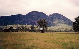 | ||
Mount Alford is a locality and town in the Scenic Rim Region of South East Queensland, Australia. At the 2011 Australian Census Mount Alford and the adjacent locality of Bunjurgen recorded a population of 344.
Contents
Map of Mount Alford QLD 4310, Australia
Geography
Teviot Brook passes just to the east of the town. Downstream is the Wyaralong Dam. Erosion along Blackrock Creek has prompted the Scenic Rim Regional Council and SEQ Catchments to implement on-farm infrastructure and land management practice changes to reduce sediment runoff and improve water quality. In the south west of the locality the land slopes upwards towards Mount Moon.
History
Mount Alford was previously known as Reckumpilla. It was renamed after Thomas Alford who managed Coochin Coochin station from 1868 onwards. A general store opened in the town in c1888 by August Anders. The building was rebuilt in 1913 upon sale by the Anders family. Mount Alford Primary school was built in 1888. A monument to those who served and who were killed in World War I was erected in 1918.
Heritage listings
Mount Alford has the following heritage-listed sites: