
Population 392 (2011 census) Postal code 4340 | Postcode(s) 4340 | |
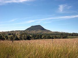 | ||
Mount Walker is a mountain and locality in the Scenic Rim Region of Queensland, Australia. The western boundary of Mount Walker is marked by the Bremer River. The central eastern parts of the locality rise to elevations above 400 m around Mount Walker. At the 2011 Australian Census Mount Walker and surrounds recorded a population of 392.
Contents
Map of Mount Walker QLD 4340, Australia
History
The mountain was originally called Mount Forbes by John Oxley in honour of Sir Francis Forbes, the Chief Justice of New South Wales. However, it was later acquired the name Mount Walker. The origins of the name Walker are believed to be a shepherd of that name from the Franklyn Vale pastoral station. The locality takes its name from the mountain.
The Mount Walker State School opened on 15 April 1878. It closed in December 1967.
Mount Walker Post Office opened on 1 October 1916 (a receiving office had been open from 1874) and closed in 1957.
The historic Mount Walker Public Cemetery is located at 1744-1752 Rosewood-Warrill View Road (27.7788°S 152.5356°E / -27.7788; 152.5356 (Mount Walker Public Cemetery)).
Amenities
The Mount Walker Church of Christ is located at 10 Hinrichsen Road, just off the Rosewood-Warrill View Road (27.7729°S 152.5374°E / -27.7729; 152.5374 (Mount Walker Church of Christ)); weekly Sunday services are held at the church. The church opened in 1884 and celebrated its 125th anniversary in 2009.