
Country Canada | Population 147,425 (2006) Area 367.10 km2 Mayor Bernard Sevigny | |
Colleges and Universities Universite de Sherbrooke, Cegep de Sherbrooke, Bishops University, Champlain College - Lennoxville, Bishops College School | ||
Map of Sherbrooke
Sherbrooke (; [ʃɛʁbʁʊk]) is a city in southern Quebec, Canada. Sherbrooke is situated at the confluence of the Saint-François (St. Francis) and Magog rivers in the heart of the Estrie administrative region. Sherbrooke is also the name of a territory equivalent to a regional county municipality (TE) and census division (CD) of Quebec, coextensive with the city of Sherbrooke. With 154,601 residents at the 2011 census, Sherbrooke was the sixth largest city in the province of Quebec and the thirtieth largest in Canada. The Sherbrooke Census Metropolitan Area had 201,890 inhabitants, making it the fourth largest metropolitan area in Quebec and nineteenth largest in Canada.
Contents
- Map of Sherbrooke
- Sherbrooke quebec a great place to live
- History
- Geography
- Climate
- Boroughs
- Neighbourhoods
- Demographics
- Census Metropolitan Area
- Economy
- Culture
- Museums and visitors centres
- Parks
- Sports
- Municipal
- Federal and provincial
- Public safety
- Military
- Transportation
- Public health
- Education
- References
Originally known as Hyatt's Mill, it was renamed after Sir John Coape Sherbrooke (1764–1840), a British general who was Lieutenant Governor of Nova Scotia (1812–1816), and Governor General of British North America (1816–1818).
Sherbrooke is the primary economic, political, cultural and institutional centre of Estrie, and was known as the Queen of the Eastern Townships at the beginning of the 20th century.
There are eight institutions educating 40,000 students and employing 11,000 people, 3,700 of whom are professors, teachers and researchers. The direct economic impact of these institutions exceeds 1 billion dollars. The proportion of university students is 10.32 students per 100 inhabitants. In proportion to its population, Sherbrooke has the largest concentration of students in Quebec.
Since the nineteenth century, Sherbrooke has been a manufacturing centre. This segment of the economy has experienced a considerable transformation in recent decades as a result of the decline of the city's traditional manufacturing sectors. The service sector occupies a prominent place in the economy of the city, as well as a growing knowledge-based economy.
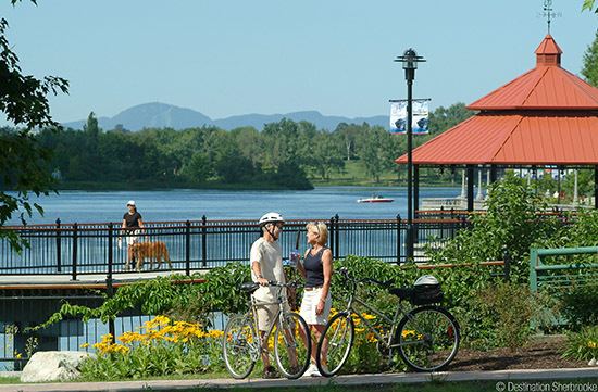
The Sherbrooke region is surrounded by mountains, rivers and lakes. There are several ski hills nearby and various tourist attractions in regional flavour. Mont-Bellevue Park, a large park in the city, is used for downhill skiing.
Sherbrooke quebec a great place to live
History
The First Nations were the first inhabitants, having originally settled the region between 8,000 and 3,000 years ago. Traces of seasonal camps, characterized by arrowheads, scrapers, and other similar tools have been found. Ceramic objects dating from the Woodland period (3000 to 500 BP) were also found, indicating that the region continued to be occupied by nomadic people during this period.
Upon the arrival of Samuel de Champlain in Quebec in 1608, this region was under the control of the Mohawks. France created an alliance through its missionaries with the Abenaki, located in Maine and Vermont. The French were driven to the valley of the St. Lawrence River near Trois-Rivières after a Mohawk victory in the war of 1660.The area around present-day Sherbrooke then became a battlefield between the two peoples who had to travel to the region, both of whom sought to obtain control of the territory. For the Abenaki, the confluence of Pskasewantekw (Magog) and Alsigôntekw (the Saint-François), present day Sherbrooke, which they named Shacewanteku ("where one smokes"), was an important resting point during the seasonal passages.
During the Seven Years' War between France and Britain, the Abenaki, still allied with the French, travelled along the rivers of the Eastern Townships, frequently near present-day Sherbrooke, during raids against British forts.
The Treaty of Paris was signed in 1783, ending the Revolutionary War and recognizing the Independence of the United States. During this time, the Eastern Townships were under Abekani control for a few years, having practised hunting and fishing for centuries. However, the American Revolution attracted British loyalists from America to the region, who began to covet the land and obtain government grants.
The first European settler to reside in the Sherbrooke region was a French Canadian named Jean-Baptiste Nolain, of whom few details are known, except that he arrived in 1779 to engage in agriculture.
The first attempts at colonization occurred in 1792 on the banks of the St. Francis River. This settlement was known as Cowan's Clearance. In 1793, loyalist Gilbert Hyatt, a farmer from Schenectady, New York, established his farm not far from the confluence of the Massawippi River and Coaticook River, before the governor of Lower Canada officially awarded the land. Over the next two years, 18 families came to live on the site. The Crown acknowledged Hyatt's ownership of the land in 1801. Hyatt built the first dam on the Magog River, in collaboration with another loyalist named Jonathan Ball, who had bought land on the north bank of the river. Hyatt then built a gristmill in 1802 on the south bank of the river, while Ball built a sawmill on the north shore. By constructing the mill, Hyatt effectively founded the small village that became known as "Hyatt's Mills". The village was named "Hyatt's Mills" until 1818, when the village was renamed after Governor General Sir John Sherbrooke at the time of his retirement and return to Britain.
In 1832, the village attracted most of the activities of the British American Land Company (BALC) and benefited from the injection of British capital into the region. Manufacturing activities were established that harnessed the Magog River's hydropower. From 1835 Sherbrooke began to seek government support to establish a railway line, but this only became a reality in 1852 through the line connecting the cities of Montreal and Portland.
From 1867 to 1892, the manufacturing system was based on hydraulic power. The Gorge of the Magog River is considered one of the best industrial sites in Quebec, since the waters never freeze there, allowing year-long production of energy. At that time, BALC invested significant sums in the reconstruction of several dams in the gorge upstream to Magog Lake, in order to regulate the flow of the river, and thus improve its efficiency, to attract new factories.
The founding of several important factories near the Gorges helped to attract more and more Francophone workers, coming mainly from the Beauce and elsewhere in Quebec. Paradoxically, it was mainly the Anglo-Protestant capital that was able to invest in these new factories, supported by the Eastern Townships Bank. The arrival of Francophones also attracted a small French Catholic bourgeoisie, but it remained modest in number and wealth.
The many new industrial investments caused the building sites on the shores of the Gorge to be quickly occupied, which limited the expansion and complicated the advent of new companies wanting to benefit from hydraulic power. In addition, the railway network, linking the city to Montreal, Portland, Lévis and several Ontario cities, was located far from the river. This caused problems for industrialists wishing to ship or receive their goods.
As early as 1871, the Massawippi Valley Railway (to be controlled by Boston & Maine in 1887), the Canadian subsidiary of the Connecticut & Passumpsic Rivers Railroad, which connects Boston to the Canadian border, ended in Sherbrooke. Subsequently, other railway projects became reality by the beginning of the 1890s, thanks to new connections to Boston, New York and Halifax.
During this time, several phenomena began to affect the hydraulic regime of the Magog. In 1895, the water level was abnormally low, which forced several companies to temporarily shut down due to lack of energy. However, thanks to technical advances in electricity, which were previously used for lighting purposes only, it could at this time be used as a driving force.
Due to its flourishing economy, Sherbrooke had 9,746 inhabitants in 1896; this growth rate is much higher compared to other industrtialized centers in Quebec.
The second half of the nineteenth century saw the establishment of academic institutions which transformed Sherbrooke into a college town.
King George VI and Queen Elizabeth visited the city by train on 12 June 1939. Over 100,000 people were estimated to be in the crowd that greeted them. They were there to build goodwill for the British Empire before they confronted Nazi Germany and the Axis Powers during World War II.
Despite the town's English name and heritage, relatively few traces of the city's English past remain, and the vast majority of the city's residents speak French.
As part of the 2000–2006 municipal reorganization in Quebec, the city grew considerably on 1 January 2002, with the amalgamation of the following towns and municipalities: Sherbrooke, Ascot, Bromptonville, Deauville, Fleurimont, Lennoxville, Rock Forest, and Saint-Élie-d'Orford. Part of Stoke was also annexed to the newly expanded Sherbrooke.
Geography
Located at the confluence of the Saint-François (St. Francis) and Magog rivers in the heart of the Eastern Townships and the Estrie administrative region. Sherbrooke is also the name of a territory equivalent to a regional county municipality (TE) and census division (CD) of Quebec, coextensive with the city of Sherbrooke. Its geographical code is 43.
Sherbrooke is the seat of the judicial district of Saint-François.
Climate
Sherbrooke has a humid continental climate (Köppen Dfb), with long, cold, and snowy winters, warm summers, and short but crisp springs and autumns. Highs range from −5.8 °C (21.6 °F) in January to 24.6 °C (76.3 °F) in July. In an average year, there are 34 nights at or colder than −20 °C (−4 °F), and 6.5 nights at or colder than −30 °C (−22 °F); 4.1 days will see highs reaching 30 °C (86 °F). Annual snowfall is large, averaging at 287 centimetres (113 in), sometimes falling in May and October. Precipitation is not sparse any time of the year, but is the greatest in summer and fall and at its least from January to April, totalling 1,100 millimetres (43.3 in) annually.
The highest temperature ever recorded in Sherbrooke was 36.7 °C (98 °F) on 1 & 2 July 1931. The coldest temperature ever recorded was −41.2 °C (−42.2 °F) on 15 January 2004.
Boroughs
In 2002, Sherbrooke merged with most of the suburban municipalities in the surrounding area: Rock Forest, Saint-Élie-d'Orford, Deauville, Fleurimont, Bromptonville, Ascot, and Lennoxville. This resulted in the creation of six boroughs for the city: Brompton, Fleurimont, Lennoxville, Mont-Bellevue, Rock Forest–Saint-Élie–Deauville, and Jacques-Cartier.
Neighbourhoods
The city includes several neighbourhoods:
Demographics
According to the 2011 Census, there were 154,601 people residing in Sherbrooke, a 4.9% increase over the 2006 Census. The city of Sherbrooke has a land area of 353.49 km2 (136.48 sq mi), and a population density of 437.356/km2 (1,132.747/sq mi). The median age of the population was 40.3 in 2011 and 84.3% of the population were aged 15 and over.
French was the first language of 129,970 people (89.9%), while English was the first language of 5,740 (4%), 7,815 (5.4%) people spoke other first languages, 640 (0.4%) had learned both English and French, while 370 (0.3%) had learned both French and another language. French was the home language of 133,175 people (92.1%), English of 5,350 (3.7%), other languages of 4,480 (3.1%), both English and French of 685 (0.5%), and French and another language of 820 (0.6%).
Census Metropolitan Area
The Census Metropolitan Area (CMA) comprises the cities of Sherbrooke, Magog and Waterville, the municipalities of Ascot Corner, Compton, Stoke and Val-Joli; the parish municipality of Saint-Denis-de-Brompton; the township municipalities of Hatley and Orford; and the village municipality of North Hatley. The population in 2011 was 201,890.
The CMA was defined slightly differently in 2006: it did not include Orford or Val-Joli. The remainder of this section applies to the 2006 census, since the applicable 2011 census figures are not yet available as of May 2012.
Indigenous peoples comprised just over 0.6% of the population.
French was mother tongue to 90.6% of residents (counting both single and multiple responses). The next most common mother tongues were English at 5.6%, Spanish at 1.3%, Arabic and Serbo-Croatian languages at 0.6% each, Persian at 0.4%, Niger–Congo languages at 0.3%, and Chinese and German at 0.2% each. (Percentages may total more than 100% owing to rounding and multiple responses).
About 87% of the population identified as Roman Catholic in 2001 while 6% said they had no religious affiliation, 1.2% were Anglican, 0.8% Muslim, 0.8% United Church, 0.7% Baptists, 0.5% Eastern Orthodox and 0.3% Jehovah’s Witnesses. Pentecostals and Methodists accounted for 0.2% each, while Buddhists, Presbyterians, Seventh-day Adventists, Mormons and Plymouth Brethren accounted for 0.1% each.
Four thousand recent immigrants (arriving between 2001 and 2006) now comprise about 2% of the total population. Approximately 13% have emigrated from Colombia, 12% from France, 7% from Afghanistan, 6% from each of Morocco and Argentina, 5% from each of Algeria and Congo, 4% from China, and 3% from each of Burundi, Tunisia, and Tanzania. About 2% of these recent immigrants were born in the United States while about 2% were born in Bosnia and Herzegovina.
Economy
Sherbrooke, which is the economic centre of Estrie, is a significant cultural, industrial, and academic hub in the province. The city is directly served by three railways that have junctions with the Canadian National and Canadian Pacific railways: the St. Lawrence and Atlantic Railroad, the Quebec Central Railway, and the Montreal, Maine and Atlantic Railway. Sherbrooke is also served by four highways as well as a regional airport, named for Sherbrooke, but located in the nearby city of Cookshire-Eaton. However the airport no longer offers commercial services as of March 2010.
According to data from the Institut de la statistique du Québec, average personal income per capita in the Census Metropolitan Area (CMA) of Sherbrooke amounted to C$30,976 in 2010. Estrie's GDP for the same year was $9.59 billion.
As of 2010, the largest employers in Sherbrooke are Université de Sherbrooke (6,000 employees), Centre hospitalier universitaire de Sherbrooke (5,511), Commission scolaire de la Région-de-Sherbrooke (3,050), Centre de santé et de services sociaux – Institut universitaire de gériatrie de Sherbrooke (2,650), City of Sherbrooke (1,913), Desjardins Group (1,713), Cégep de Sherbrooke (800), Centre Jeunesse de l'Estrie (527), Nordia Inc. (500), Canada Post (497), Kruger Inc. - Publication papers business unit (455), Bishop's University (450) and McDonald's (400).
Culture
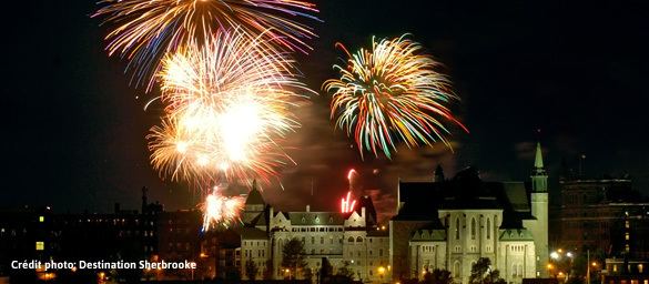
In the summer season, several festivals, concerts, and events are held in the city, such as the Fête du Lac des Nations, Sherblues & Folk, and the Festival des traditions du monde. Come winter, the city hosts the Carnaval de Sherbrooke.
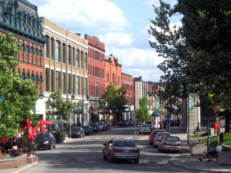
The city has British architectural heritage, as seen in the buildings in Vieux-Nord.
The city has the fourth largest theatre in Quebec, the Maurice O'Bready University Cultural Centre of Sherbrooke. Music, theatre, and dance shows are staged there. The Centennial Theatre of Bishop's University also hosts music and dance concerts from around the world. The Vieux Clocher, owned by the Université de Sherbrooke, has two stages, the primary being used by various music groups and comedians from around the province. The Théâtre Granada, designated as a historical site by the Canadian government, holds music concerts. It has retained its original architecture since its opening. The Petit Théâtre de Sherbrooke, located downtown, presents musicals and plays for children.
Since 2007, the Centre des arts de la scène Jean-Besré (CASJB), built by the city with the support of the Ministry of Culture and Communications, has assisted in the creation and production of material for the region's artistic community. Currently it serves as the location for training theatre, music, and dance professionals. It contains three rehearsal studios, a production room, a decoration workshop, and a costume workshop, as well as administrative offices for each of its resident companies.
Museums and visitors' centres
Parks
Sherbrooke has parks and greenspaces that encompass a variety of recreational activities. In total, there are 108 in the municipality. Parks Jacques-Cartier, Mont Bellevue, Bois Beckett, Lucien-Blanchard, Central, Quintal, Victoria, and Marais Réal-D.-Carbonneau are among the most popular destinations.
Sports
The Sherbrooke Expos of the Ligue de Baseball Senior Élite du Québec play their home games at Amedée Roy Stadium. There have been various baseball teams from the Eastern League, Canadian Baseball League and Ligue de Baseball Élite du Québec in addition to hosting the 2002 World Junior Baseball Championships. The Sherbrooke Phoenix is a junior hockey team playing in the Quebec Major Junior Hockey League.
Municipal
The current mayor of Sherbrooke is Bernard Sévigny.
The merged city is composed of six boroughs: Brompton, Fleurimont, Lennoxville, Mont-Bellevue, Rock Forest–Saint-Élie–Deauville and Jacques-Cartier. Each of the boroughs is subdivided into electoral districts, with the number varying based on population. For example, there are only two districts in Brompton, which only has 6,314 inhabitants, whereas Fleurimont (pop. 40,824) has five. Sherbrooke has 21 districts total, for which the average population is 7,200 inhabitants.
Federal and provincial
Sherbrooke is split into the federal electoral districts of Sherbrooke, represented by Pierre-Luc Dusseault of the New Democratic Party (NDP) and Compton—Stanstead, represented by Marie-Claude Bibeau of the Liberals.
Provincially, Sherbrooke is divided into two electoral districts. Sherbrooke is represented by Serge Cardin of the Parti Québécois (PQ), and Saint-François is represented by Rejean Hebert of the PQ.
Public safety
In 2007, the crime rate was 5,491 per 100,000.
Military
Sherbrooke does not host any units from the Regular Force with the exception of a recruiting centre, but four Primary Reserve units are stationed in the city:
A Canadian military artifact is preserved at the William Street Armoury, the Sherman tank "Bomb" which helped liberate Europe fighting with the Sherbrooke Fusilier Regiment and is the only Canadian tank to have landed on the Normandy beach on D-Day and fought through to VE Day without being knocked out.
Transportation
Sherbrooke Airport, in Cookshire-Eaton is just east of the city. There are currently no scheduled flights operating out of the airport.
Transdev Limocar provides bus service to Montreal via Granby and Magog. Formerly, Autobus Jordez linked Sherbrooke to Drummondville and Trois-Rivières, and also to Victoriaville and Quebec City, but since the company lost their licence to operate heavy vehicles, they have sold their licence to Autobus La Québécoise, who now provide the service.
Société de transport de Sherbrooke (STS) provides bus service within the city. It operates 17 bus routes, 11 minibus routes, and 5 taxibus routes.
The city is located at the eastern terminus of A-10, and directly on the Autoroute Trans-Québécoise (A-55). A-10 provides a direct freeway connection to Montreal and points west, while A-55 connects directly to Trois-Rivières, Shawinigan, and points north, as well as to Interstate 91 to the south (Vermont). A-410 and A-610 are the southern and northern bypass roads, respectively.
Public health
The suburban Sherbrooke University Hospital ("CHUS" or "Centre Hospitalier Universitaire de Sherbooke) has over 5,200 employees, including 550 doctors. It includes a clinical research facility, the Etienne-Lebel Research Center.
Education
Sherbrooke has eight institutions that make up the Sherbrooke University Pole, which educates some 40,000 students and employs about 11,000 persons. University students comprise 10.32% of the population, the highest concentration in Quebec.
The city is the location of one French-language university, the Université de Sherbrooke, and an English-language university, Bishop's University. Université de Sherbrooks is a comprehensive university with schools of medicine and law and extensive graduate programs. Bishop's University is smaller and predominantly undergraduate. There are three CEGEPs in Sherbrooke, two of them French-language, the Cégep de Sherbrooke and the Séminaire de Sherbrooke, and one English-language, Champlain College Lennoxville.