
Length 591 km | ||
 | ||
The Route nationale 9, or RN 9, was a trunk road (nationale) in France between Moulins and the frontier with Spain.
Contents
- Map of Route Nationale 9 03800 Gannat France
- Reclassification
- Route
- Moulins to Clermont Ferrand 0 km to 103 km
- Clermont Ferrand to Bziers 103 km to 444 km
- Bziers to Perthus 444 km to 574 km
- References
Map of Route Nationale 9, 03800 Gannat, France
Reclassification
Much of the route of the RN 9 has now been/or in the process of being upgraded or replaced by the A75 autoroute in particular the section south of Clermont Ferrand to Béziers. Depending on which Department the road is in the old road is now numbered as various RD numbers:
Route
Moulins-Clermont Ferrand-Béziers- Narbonne - Perpignan - Spain
Moulins to Clermont Ferrand (0 km to 103 km)
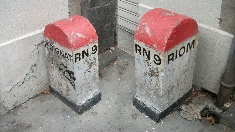
The road begins at Moulins with a junction with the RN 7. The road heads Southwest over the River Allier. The road follows the West bank of the river to Saint-Pourçain-sur-Sioule crossing the river and following it South. At Gannat the road meets the A 719, which connects Vichy, 20 km to the East, and the A71 autoroute. The RN 9 continues South to Riom and the volcanic region of Auvergne. The road is dual-carriageway for 10 km into the industrial city of Clermont-Ferrand.
Clermont Ferrand to Béziers (103 km to 444 km)
After Clermont the road heads through the Massif Central countryside. Much of the RN 9 has now been upgraded or replaced by the A75 autoroute between Clermont-Ferrand and Béziers.
The original RN 9 has now been renumbered the RD 909,RD 809 and D 2009 and passes through small villages and towns now bypassed by the autoroute La Méridienne which now takes the majority of through traffic. The route follows the upper Allier valley to Issoire before joining the Gorges de l'Allagnon and then climbing to cross the Col de Fageole (1114 m) and onto Saint-Flour and the Gorges de l’Ander. The old RN 9 then follows the banks of the dammed River Truyére under the Viaduc de Garabit.
The countryside is very scenic consisting of rolling green wooded hills and steep sided river vallies. The road has a junction with the RN 106 at Saint-Chély-d'Apcher. The road then crosses the Col des Issartets (1121 m) after which the former route of the RN 9 passes to the East of the autoroute passing through the small town of Marvejols and into the Lot valley.
The road then enters Causse country a series of barren limestone plateaux divided by deep river valleys. The road passes between the Causse de Sévérac and Causse de Sauveterre before reaching Sévérac-le-Château and the RN 88 which heads to the West.
The road passes the Source of the Aveyron and into the Parc Natural Régional des Grandes Causses. After crossing the Col d'Engayresque (888 m) the RN 9 re-appears and drops into the Gorges du Tarn and onto Millau where the road crosses the river and climbs up to the Causse du Larzac offering spectacular views of the valley and viaduct. The RN 9 provides a trunk road route avoiding the toll on the Autoroute A 75 as it crosses the valley on the spectacular Viaduc de Millau. The countryside is now barren and sun-baked. The RN 9 has again been replaced by the A 75 for this section.
At the Pas de l'Escalette just South of Le Caylar Roches the road enters a gorge leading South off the Causse du Larzac and on toward the coastal plain and the Mediterranean. Historically, RN 9 used to cross the River Lergue at Pegairolles de l'Escalette and follow what is now the treacherous D 149 and D 151 right through the city of Lodève. After a series of improvements starting in the late 1960s, the road now stays on the left bank of the Lergue and by-passes Lodève through the Tunnel de la Vierge. It skirts the Lac du Salagou (which it once ran right through) before reaching Clermont L'Hérault and a junction with the RN 109 to Montpellier. The RN 9 demerges from the A75 autoroute again at Clermont-l'Hérault, and follows the Hérault Valley south to Pézenas. The roads run parallel to each other with a new extension of the A 75 to Béziers and the A9 autoroute scheduled to be completed in 2008.
Béziers to Perthus (444 km to 574 km)
After Béziers the A9 autoroute runs parallel to the route of the RN 9 and takes the majority of through traffic from Béziers. There the road crosses the Canal du Midi and River Orb and continues over the river Aude to Narbonne. The section south of Béziers is reclassified as the D 6009. Thereafter the road heads along the Étang de Bages et de Sigean as the mountains push further East. The road is overlooked here by the Massif de Fontfroide and thereafter heads through the vineyards of Fitou. The road passes round the shores of the Étang de Leucate ou de Salses.
The road enters Northern Catalonia at the Fort de Sales. The road is downgraded to the D 900 and passes through the plain of Roussillon to the city of Perpignan where it crosses the Têt and Tech rivers. The plain is dominated by the Pyrénées to the South and the Corbières mountains to North. It then passes Le Boulou where it enters the Monts Albères which form the Eastern ridge of the Pyrénées. The road climbs to the frontier at Le Perthus and the Col du Perthus where the road enters Spain, in the village of Els Límits. The road continues as the N-II/A-2 in Spain. The adjacent autoroute A 9 becomes the Autopista AP-7.