
 | ||
Asmr ear to ear binaural whisper binaural northern catalonia trip to perpignan
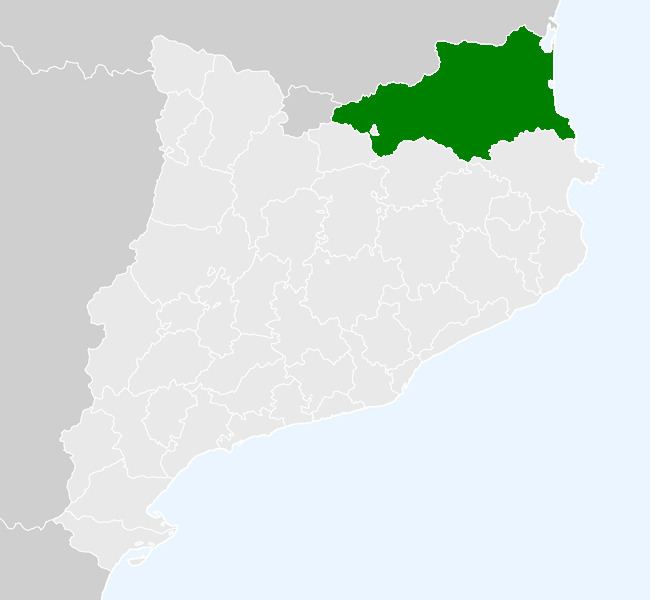
Northern Catalonia (Catalan: Catalunya Nord [kətəˈɫuɲə ˈnɔrt], French: Catalogne Nord) refers to the territory ceded to France by Spain through the signing of the Treaty of the Pyrenees in 1659. The area corresponds approximately to the modern French département of the Pyrénées-Orientales.
Contents
- Asmr ear to ear binaural whisper binaural northern catalonia trip to perpignan
- Geography
- Cerdagne
- Spanish marches and County of Barcelona
- Crown of Aragon and Kingdom of Spain
- After the Treaty of the Pyrenees and cession to France
- Present day
- Languages
- References
The equivalent term in French, Catalogne Nord, is used nowadays, although less often than the more politically neutral Roussillon (in reference to the pre-Revolutionary province). Sometimes French Catalonia can also be used.
Geography
Northern Catalonia forms a triangle between the Pyrenees to the south, the Corbières to the north-west and the Mediterranean Sea to the east. The Roussillon plain in the east, by far the most populated area, is formed by the flood plains of the Tech, Têt and Agly rivers (Catalan: Tec, Tet, Aglí). The districts of Vallespir and Conflent cover the upper valleys of the Tech and the Têt respectively. The massif of the Canigou (Catalan: Canigó), 2785 m, dominates much of the territory.
The climate is of the Mediterranean type, with hot, dry summers and winters which are relatively mild, at least on the Roussillon plain where snow is rare.
The city of Perpignan (Catalan: Perpinyà) accounts for over a quarter of the population, over one-third if its urban area is taken into account, and is the only major administrative and service centre. Major road and rail links run north–south through Northern Catalonia between France and Spain, while a railway line also links Perpignan to Latour-de-Carol (Catalan: La Tor de Querol) via Prades (Catalan: Prada de Conflent or Prada).
Cerdagne
Haute-Cerdagne (Catalan: Alta Cerdanya) is geographically distinct from the rest of Northern Catalonia, lying to the south of the Pyrenean watershed in the upper valley of the Segre. It is a mountainous and sparsely-populated district, even taking into account the town of Llívia (pop. 1252 (2005)) which forms an enclave resting under Spanish sovereignty.
The district lies on the most direct route between Toulouse (Occitan: Tolosa de Lengadoc) and Barcelona (via Foix and Ripoll), and a railway line still links the two cities via Latour-de-Carol (Catalan: La Tor de Querol).
Spanish marches and County of Barcelona
Northern Catalonia formed part of the Spanish Marches, established by Charlemagne as a buffer territory against the Moorish forces. As such, it was divided into feudal counties, Rosselló, Vallespir, Conflent north of the Pyrenees and Cerdanya to the south. By the end of the ninth century, these counties had gained de facto independence from the Carolingian kings and operated as princely states (whose rulers nevertheless retained the title of count).
As the seigneury of the counties became hereditary, the total number of Catalan counts fell steadily. One individual often had the charge of several counties, but these were not always transmitted on the basis of primogeniture. Hence Count Miró II the Young, third son of Wilfred I the Hairy, inherited the counties of Cerdanya and Conflent from his father in 897, and the counties of Besalú and Vallespir from his elder brother Sunyer I when the latter became Count of Barcelona in 911.
The Counts of Rosselló, in alliance with their cousins the Counts of Empuriés, tried to resist this dilution of their power. However the Counts of Barcelona steadily gained suzerainty over the other Catalan counts, a process which was virtually complete by the twelfth century. The last Count of Rosselló, Girard II, left his title to the Crown of Aragon on his death in 1172 to prevent the territory passing to his illegitimate half-brothers.
Crown of Aragon and Kingdom of Spain
Royal administration in Catalonia under the Crown of Aragon was organised on the basis of vegueries, under the charge of a veguer appointed by the King of Aragon as Count of Barcelona. In Northern Catalonia, the vegueries followed closely the boundaries of the old counties. The district of Capcir was a sotsvegueria, based around the castle of Puigbalador (French: Puyvalador) but subordinate to the vegueria of Conflent.
The Treaty of Corbeil of 1258 confirmed the frontier between France and Aragon as the Cerbères, leaving the Occitan district of Fenolheda to France.
On the death of King James I the Conqueror in 1276, Northern Catalonia was combined with the Balearic Isles to form a new Kingdom of Majorca, which passed to James II while the rest of the territory of the Crown of Aragon passed to his brother Peter III. This division satisfied neither branch of the family, and the Kingdom of Majorca was retaken militarily by the Crown of Aragon in 1344.
After the Treaty of the Pyrenees and cession to France
The Treaty of the Pyrenees of 1659 ceded Northern Catalonia to France, where it became the province of Roussillon. The French provinces were abolished at the Revolution (Law of 1789-12-22), and Roussillon was joined with the district of Fenouillèdes (Occitan: Fenolheda) to form the département of the Pyrénées-Orientales, with Perpignan (Perpinyà) as its administrative centre.
Present day
The département of the Pyrénées-Orientales is divided into the arrondissements of Céret (Catalan: Ceret), Perpignan (Perpinyà) and Prades (Prada de Conflent), which are further divided into cantons and communes. Perpignan and sixteen surrounding communes are also associated in the Communauté d'agglomération Têt Méditerranée, created in 2001. Enclaved in the southwest of the département there is the Spanish (Catalonia) exclave of Llívia.
As is common, the present-day arrondissements do not correspond to pre-Revolutionary boundaries. The arrondissement of Prades (Prada) covers the whole of Haute-Cerdagne (Alta Cerdanya) and Conflent (including Capcir), as well as about a third of Fenolheda (not part of the province of Roussillon). The arrondissement of Céret covers the whole of Vallespir but also the Côte Vermeille (Costa Vermella), which was historically under the control of the counts and veguers of Rosselló at Perpinyà (Perpignan).
Catalan writers sometimes speak of the "comarques of Northern Catalonia". Unlike the autonomous community of Catalonia, these comarques have no administrative significance, although they usually correspond to a certain historical and geographical unity. A commonly used division is that of Joan Becat in his 1977 work Atles de Catalunya Nord, which follows closely the boundaries of the former vegueries except insofar as it promotes the former sotsvegueria of Capcir (177 km², pop. 1532 (1990)) to a full comarca.
Languages
French is the only official language in France as a whole and in these municipalities. Catalan, in its Northern Catalan variety, is recognized as a regional language only by the region of Languedoc-Roussillon; it then benefits from cultural support in education and in public medias, with some more regional power since the laws of regionalisation of France during the 1980s. It is estimated to be spoken by a third of the population, but understood by another fifth.
In 1700, the government of Louis XIV prohibited the use of the Catalan language in official documents, although the government only irregularly enforced the edict throughout the eighteenth century. In the 1950s, after centuries of being forbidden in education, the Catalan language was permitted to be studied for one hour per week in secondary school. In the 1970s, the Arrels Association and la Bressola network of private schools started to offer complete bilingual French/Catalan classes from nursery up to secondary education.
On December 10, 2007, the General Council of the Pyrénées-Orientales proclaimed Catalan as one of the languages of the department, alongside French and Occitan (in Fenouillèdes), with the goal to further promote it in public life and education.