
Gaelic name Hiort OS grid reference NF092998 Highest elevation 430 m (1,410 ft) Area 6.7 km² Lieutenancy area Outer Hebrides | Meaning of name Uncertain Area rank 65 Sovereign state United Kingdom Council area Outer Hebrides | |
 | ||
Trevor morrison hirta the lost songs of st kilda piano
Hirta (Scottish Gaelic: Hiort) is the largest island in the St Kilda archipelago, on the western edge of Scotland. The names "Hiort" (in Scottish Gaelic) and "Hirta" (historically in English) have also been applied to the entire archipelago.
Contents
- Trevor morrison hirta the lost songs of st kilda piano
- Map of Hirta United Kingdom
- St kilda hirta part 1
- GeographyEdit
- EtymologyEdit
- PopulationEdit
- Surrounding stacksEdit
- References
Map of Hirta, United Kingdom
St kilda hirta part 1
GeographyEdit
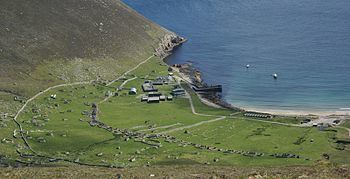
The island measures 3.4 kilometres (2.11 mi) from east to west, and 3.3 kilometres (2.05 mi) from north to south. It has an area of 6.285 square kilometres (2.427 sq mi) and about 15 km (9.3 mi) of coastline. The only real landing place is in the shelter of Village Bay on the southeast side of the island. The island slopes gently down to the sea at Glen Bay (at the western end of the north coast), but the rocks go straight into the sea at a shallow angle and landing here is not easy if there is any swell at all. Apart from these two places, the cliffs rise sheer out of deep water. However, sea kayakers can also land for a break on a small boulder beach backed by cliffs in the north of the island, just before the northeast side where the highest summit in the island, Conachair, forms a precipice 430 m high (1,410 ft). St Kilda is probably the core of a Tertiary volcano, but, besides volcanic rocks, it contains hills of sandstone in which the stratification is distinct.
Dùn is separated from Hirta by a shallow strait about 50 metres (55 yd) wide, which is normally impassable but is reputed to dry out on rare occasions.
EtymologyEdit
The origin of Hirta is open to interpretation. Martin (1703) states that "Hirta is taken from the Irish Ier, which in that language signifies west". Maclean offers several options, including an unspecified Celtic word meaning "gloom" or "death", later suggested to be Ei hirt – dangerous or deathlike, or the Scots Gaelic h-Iar-Tìr ("westland"). Drawing on an Icelandic saga describing an early 13th-century voyage to Ireland that mentions a visit to the islands of "Hirtir", he speculates that the shape of Hirta resembles a stag, (Hirtir meaning "stags" in Norse). Steel (1998) quotes the view of Reverend Neil Mackenzie, who lived there from 1829 to 1844, that the name is derived from the Gaelic Ì Àrd ("high island"), and a further possibility that it is from the Norse Hirt ("shepherd"). In a similar vein, Murray (1966) speculates that the Norse Hirðö, pronounced 'Hirtha' ("herd island"), may be the origin.
PopulationEdit
The islands were continuously populated from prehistoric times until 1930, when the remaining inhabitants were evacuated. On 29 August the 36 inhabitants were removed to Morvern on the Scottish mainland at their own request.
The morning of the evacuation promised a perfect day. The sun rose out of a calm and sparkling sea and warmed the impassive cliffs of Oiseval. The sky was hopelessly blue and the sight of Hirta, green and pleasant as the island of so many careless dreams, made parting all the more difficult. Observing tradition the islanders left an open Bible and a small pile of oats in each house, locked all the doors and at 7 am boarded the Harebell. Although exhausted by the strain and hard work of the last few days, they were reported to have stayed cheerful throughout the operation. But as the long antler of Dun fell back onto the horizon and the familiar outline of the island grew faint, the severing of an ancient tie became a reality and the St Kildans gave way to tears.
St. Kilda was part of the Lordship of the Isles, then a property of the MacLeods of Dunvegan from 1498 until 1930. There were three chapels on St. Kilda, dedicated to Saint Brendan, Saint Columba, and Christ Church, but little remains. There are also the remains of a beehive house, known as the Amazon's House.
The islanders had a tough life, and survived by exploiting the thousands of sea birds living on the islands. There are a large number of cleits, huts used for storing dried sea birds, fish, hay and turf. The islanders had a very democratic system, and decisions were taken by an island council, made up of all the menfolk. The present village was set out in the 1830s above Village Bay; in the 1880s some of the population left for Australia, with the remaining inhabitants being evacuated in 1930.
The island was bequeathed to the National Trust for Scotland in 1957 and was designated as Scotland's first World Heritage Site in 1987. It is possible to visit the island. The Ministry of Defence established a base on Hirta for tracking missiles fired from the station on South Uist.
Surrounding stacksEdit
Hirta is surrounded by a number of small stacks. Bradastac, Mina Stac and Sgeir Domhnuill lie under the cliffs of Conachair to the east and Sgeir nan Sgarbh further south under the heights of Osieval. An Torc is west of Ruabhal and Sgeir Mhòr is further north under Mullach Bi.
There are also various large stacks in the narrow strait between Hirta and Soay: Stac Dona, Stac Soay and Stac Biorach.