
Time zone WET (UTC+0) | Irish Grid Reference B853466 Area code 074 | |
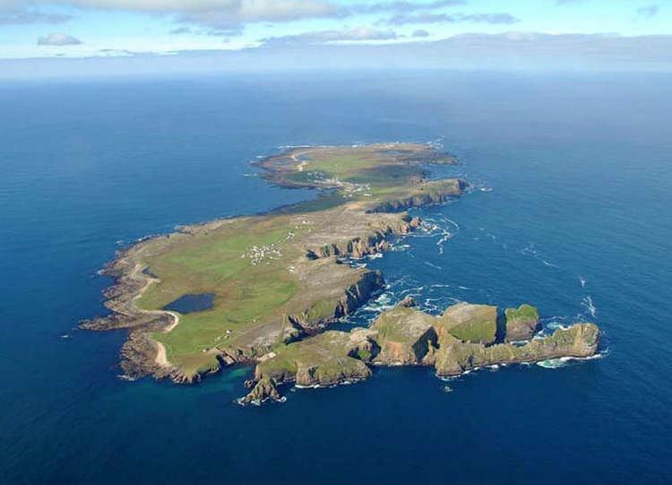 | ||
Tory island co donegal ireland
Tory Island, or simply Tory (officially known by its Irish name Toraigh), is an island 14.5 kilometres (9.0 miles) off the north-west coast of County Donegal in Ireland. It is also known in Irish as Oileán Thoraí or, historically, Oileán Thúr Rí.
Contents
- Tory island co donegal ireland
- Map of Tory Island Co Donegal Ireland
- Aras in cholmcille self catering tory island donegal ireland
- LanguageEdit
- Geography and transportEdit
- Ancient historyEdit
- Early modern historyEdit
- Recent historyEdit
- DemographicsEdit
- TourismEdit
- Flora and faunaEdit
- References
Map of Tory Island, Co. Donegal, Ireland
Aras in cholmcille self catering tory island donegal ireland
LanguageEdit
The main spoken language on the island is Irish, although English is spoken to communicate with visitors. Tory is part of the Donegal Gaeltacht and Ulster Irish is the main Irish dialect in use.
Geography and transportEdit
The island is approximately 5 kilometres (3 miles) long and 1 kilometre (0.6 miles) wide. The 2002 census recorded a population of 133. The population is divided among four towns – An Baile Thoir (East Town), An Baile Thiar (West Town), An Lár (Middletown) and Úrbaile (Newtown). In August 2010, the King of Tory confirmed that there were 96 people living on the island.
Petrol and diesel are available from Tory Oil at prices significantly higher than on the mainland.
Tory has no airport, but has regular ferry connections from mainland County Donegal. The ferry travels daily from April to October and five times a week for the rest of the year. The ferry does not take cars, but holds up to 70 passengers. During the winter months, sea crossings may not be possible due to rough seas – but from November to March, a small 4-seater helicopter runs from Falcarragh to Tory every other Thursday.
Ancient historyEdit
In the apocryphal history of Ireland, Lebor Gabála Érenn, Tory Island, was the site of Conand's Tower, the stronghold of the Fomorians, before they were defeated by the Nemedians in a great battle on the island. The later Fomorian king Balor of the evil eye also lived here. Balor would imprison Ethlinn in a tower built atop Tor Mór (or Túr Mór in Old Irish, meaning The High Tower). Tor Mór is the island's highest point.
A monastery was founded on Tory in the 6th century by Colmcille. The monastery dominated life on the island until 1595, when it was plundered and destroyed by English troops, waging a war of suppression against local chieftains. The monastery's bell tower is the largest structure to survive and was built in the 6th or 7th century.
Early modern historyEdit
In 1608, the Siege of Tory Island, one of the final incidents of O'Doherty's Rebellion, took place when a surviving group of rebels took shelter in the castle, only to begin killing each other to secure a pardon.
The Battle of Tory Island, the last action in the Irish Rebellion of 1798, took place at sea nearby.
Recent historyEdit
On 27 October 1914, the British lost their first battleship of World War I: The British super-dreadnought battleship HMS Audacious (23,400 tons) was sunk off Tory Island, by a minefield laid by the armed German merchant-cruiser Berlin. The loss was kept an official secret in Britain until 14 November 1918 (3 days after the end of the war). The sinking was witnessed and photographed by passengers on RMS Olympic sister ship of RMS Titanic.
Since the 1950s, the island has been home to a small community of artists, and has its own art gallery. The English artist Derek Hill was associated with the Tory artist community.
Reflecting a long-standing tradition, a "king" is chosen by consensus of the islanders. The current Rí Thoraí (Irish for "King of Tory") is painter Patsy Dan Rodgers (Patsaí Dan Mac Ruaidhrí). The king has no formal powers, though duties include being a spokesperson for the island community and welcoming people to the island.
Power is generated on the island today from three diesel electricity generators. These have a total capacity of 4 MW and burn through approximately 500 litres of fuel every day.
Public attention was focused on the island in 2009 when a one-time resident was awarded a payout following a court case after his house was demolished and the grounds used as a car park. In 2015, the island's only café was destroyed by fire.
DemographicsEdit
The table below reports data on Tory Island's population taken from Discover the Islands of Ireland (Alex Ritsema, Collins Press, 1999) and the census of Ireland. Censuses in Ireland before 1841 are not considered complete and/or reliable.
TourismEdit
Tory Island has a number of historical and mythological sites:
Flora and faunaEdit
The island is an Important Bird Area. It is a breeding site for corn crakes (Crex crex), a globally threatened species whose numbers have fallen with the intensification of agriculture. In 2007, Tory Island recorded 18 calling males, down from a recent year's maximum of 34 calling males in 2003. In addition to its indigenous bird life, the island records many vagrants.
Ancient records of the flora and fauna of this island can be found in Hyndman's notes on the history of the island. Algae found locally include: Fucus vesiculosus, Fucus nodosus, Himanthalia lorea, Laminaria digitata, Rhodomenia laciniata, Plocamium coccineum, Ptilota plumosa, Conferva rupestrus, Codium tomtntosum, Codium adhaerens det Dr Harvey.
The island has no trees due to its high winds.