
Country United States County Cheshire Time zone Eastern (UTC−5) Elevation 395 m Population 6,014 (2010) | Incorporated 1768 Area code(s) 603 Zip code 03461 | |
 | ||
Weather -2°C, Wind SE at 2 km/h, 59% Humidity University | ||
Rindge is a town in Cheshire County, New Hampshire, United States. The population was 6,014 at the 2010 census. Rindge is home to Franklin Pierce University, the Cathedral of the Pines, and part of Annett State Forest.
Contents
- Map of Rindge NH USA
- Native American inhabitants
- Settlement by European colonists
- Geography
- Demographics
- Education
- Sites of interest
- Notable people
- References
Map of Rindge, NH, USA
Native American inhabitants
The land in and around Rindge was originally inhabited by ancestors of the Abenaki tribe of Native Americans. Archeological evidence from nearby Swanzey indicates that the region was inhabited as much as 11,000 years ago (coinciding with the end of the last glacial period). As much as half of the Western Abenakis were victims of a wave of epidemics that coincided with the arrival of Europeans in the late 16th and early 17th centuries. Later, many of the Western Abenaki present in southwestern New Hampshire chose to relocate to Canada during Colonial times, primarily due to their allegiance with the French during the French and Indian Wars.
Settlement by European colonists
In the eighteenth century, Massachusetts granted unappropriated land to veterans of Sir William Phipps' 1690 expedition against French-held Canada as compensation for services. Whole townships were granted to certain military companies and became known as "Canada" townships. Granted in 1736 by Governor Jonathan Belcher to soldiers from Rowley, Massachusetts, Rindge was first known as Rowley-Canada. But the Masonian proprietors were making competing claims to the area, and in 1740 commissioners of the Crown decided that the boundary between Massachusetts and New Hampshire lay south of Rowley-Canada. Consequently, it was re-granted in 1749 by Governor Benning Wentworth as Monadnock No. 1, or South Monadnock. The town would be incorporated in 1768 by Governor John Wentworth as Rindge, in honor of Captain Daniel Rindge of Portsmouth, one of the original grant holders, and the one who represented New Hampshire's claim to the land before the king.
Captain Abel Platts is credited as being Rindge's first temporary settler, arriving in 1738 to take possession of his family's land grant. But disputes about the grants, combined with the outbreak in 1744 of King George's War, made it untenable to remain in Rindge, so early settlers abandoned it. Platts and others returned in 1752, and starting in 1758, settlement increased steadily. There were 1,274 residents by 1859, when water powered industries included three gristmills, thirteen sawmills, thirteen shingle mills, six stave mills, two planing mills, and several clapboard mills.
Geography
According to the United States Census Bureau, the town has a total area of 40.0 square miles (104 km2), of which 37.2 sq mi (96 km2) is land and 2.8 sq mi (7.3 km2) is water, comprising 6.93% of the town. Rindge is located in a hilly upland lake region. Hubbard Pond is in the northeast, Contoocook Lake on the northern boundary, Pearly Lake is in the northwest, and Lake Monomonac is on the southern boundary. The town is located on a regional watershed divide and is the headwaters for two river systems. The Contoocook River flows north to the Merrimack River, thence to the Gulf of Maine, and the North Branch of the Millers River flows southwest to the Connecticut River, thence to Long Island Sound. Rindge's highest point is on its eastern border, on the lower slopes of Pratt Mountain, where the elevation reaches 1,505 feet (459 m) above sea level.
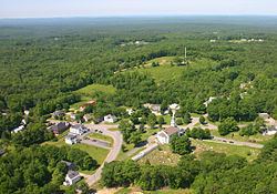
Rindge is home to the villages of Rindge Center, East Rindge, Converseville, and West Rindge. The town is crossed by U.S. Route 202 and New Hampshire Route 119.
Demographics
As of the census of 2000, there were 5,451 people, 1,502 households, and 1,138 families residing in the town. The population density was 146.6 people per square mile (56.6/km2). There were 1,863 housing units at an average density of 50.1 per square mile (19.3/km2). The racial makeup of the town was 97.21% White, 1.16% African American, 0.15% Native American, 0.33% Asian, 0.02% Pacific Islander, 0.40% from other races, and 0.73% from two or more races. Hispanic or Latino of any race were 0.88% of the population. 15.1% were of English, 11.2% Finnish, 11.0% Irish, 9.5% French, 9.3% French Canadian, 8.9% American and 7.5% Italian ancestry according to Census 2000.
There were 1,502 households of which 38.3% had children under the age of 18 living with them, 65.4% were married couples living together, 6.6% had a female householder with no husband present, and 24.2% were non-families. 18.6% of all households were made up of individuals and 5.3% had someone living alone who was 65 years of age or older. The average household size was 2.87 and the average family size was 3.30.
In the town, the population was spread out with 24.1% under the age of 18, 26.3% from 18 to 24, 22.0% from 25 to 44, 19.8% from 45 to 64, and 7.7% who were 65 years of age or older. The median age was 24 years. For every 100 females there were 103.5 males. For every 100 females age 18 and over, there were 102.4 males.
The median income for a household in the town was $50,494, and the median income for a family was $52,500. Males had a median income of $36,268 versus $27,204 for females. The per capita income for the town was $18,495. About 4.3% of families and 7.6% of the population were below the poverty line, including 11.5% of those under age 18 and 3.3% of those age 65 or over.
Education
Rindge belongs to the Jaffrey-Rindge Cooperative School District, which has a total of four schools. Rindge is also the home of Franklin Pierce University.