
Age of rock 400.265424 million years | Elevation 554 m | |
 | ||
Similar New Ipswich Mountain, Barrett Mountain, Kidder Mountain, Mount Watatic, North Pack Monadnock | ||
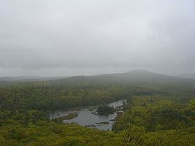
Pratt mountain 2 10 2013
Pratt Mountain is a 1,817 feet (554 m) summit within the Wapack Range of mountains in south-central New Hampshire, United States. It lies within the town of New Ipswich and is traversed by the 22 mi (35 km) Wapack Trail. The subordinate peak, Stony Top, 1,760 feet (540 m), forms the north shoulder of the mountain. Pratt Mountain offers expansive views from rocky ledges along its length.
Contents
- Pratt mountain 2 10 2013
- Map of Pratt Mountain New Ipswich NH 03071 USA
- Coming off pratt mountain from danita lane
- References
Map of Pratt Mountain, New Ipswich, NH 03071, USA
New Ipswich Mountain is located directly to the north along the Wapack ridgeline; to the southeast rise Binney Hill 1,441 feet (439 m), Emerson Hill 1,551 feet (473 m), Nutting Hill 1,620 feet (490 m), and Mount Watatic, the southern terminus of the Wapack Range.
The east side of the mountain drains into the Souhegan River watershed, to the Merrimack River thence the Atlantic Ocean; the west and south sides drain into the Millers River watershed, to the Connecticut River, thence into Long Island Sound. Binney Pond, located in Binney Pond State Forest along the Wapack ridgecrest between Pratt Mountain and Binney Hill, is known for a biodiversity of rare plants and salamanders.