
Area 179,008 km² | ||
 | ||
Islands Smuttynose Island, Appledore Island, Malaga Island | ||
Cashes ledge jewel of the gulf of maine
The Gulf of Maine (French: Golfe du Maine) is a large gulf of the Atlantic Ocean on the east coast of North America.
Contents
- Cashes ledge jewel of the gulf of maine
- Map of Gulf of Maine
- A climate calamity in the gulf of maine the lobster pot heats up
- Geographic features and biological importance
- Gulf of Maine watershed
- History and political significance
- References
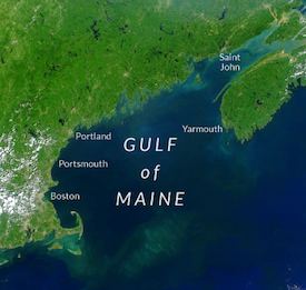
Map of Gulf of Maine
It is delineated by Cape Cod at the eastern tip of Massachusetts in the southwest and Cape Sable Island at the southern tip of Nova Scotia in the northeast. It includes the entire coastlines of the U.S. states of New Hampshire and Maine, as well as Massachusetts north of Cape Cod, and the southern and western coastlines of the Canadian provinces of New Brunswick and Nova Scotia, respectively.
Both Massachusetts Bay and the Bay of Fundy are included within the Gulf of Maine system. As such, the Gulf of Maine is also home to the highest tidal variations on the planet (see Bay of Fundy for further information).
A climate calamity in the gulf of maine the lobster pot heats up
Geographic features and biological importance
The coastline of the Gulf of Maine is predominantly rocky and scenic; the only significant coastal developments are located in the Boston, Portsmouth, Portland and Saint John metropolitan areas. The effects of glaciation are responsible for stripping sedimentary soil away from the coastline, therefore the gulf lacks the sandy beaches found to the south along the Eastern Seaboard. The underwater features of the seabed sculptured during the lower sea levels of the ice ages make the gulf a semi-enclosed sea bounded to the south and east by underwater banks. Georges Bank in particular, on its southern end, protects the Gulf of Maine waters from the Gulf Stream. Gulf of Maine waters are more strongly influenced by the Labrador Current, making the gulf waters significantly colder and more nutrient-rich than those found to the south. Undersea valleys in the central basin can reach depths of 1,500 feet (500 m) while undersea mountains rise up 800 feet (266 m) from the sea floor, almost reaching the surface in some locations, or even exceeding it, creating islands.
There are three major basins contained within the Gulf of Maine: Wilkinson Basin to the west, Jordan Basin in the northeast, and Georges Basin in the south, which are isolated from each other beneath the 650 foot (200 m) isobath. Georges Basin, just north of Georges Bank, is the deepest of the three at just over 1200 feet (370 m) and generates a pocket at the end of the Northeast Channel, a deep fissure between Georges Bank and Browns Bank, the southwestern edge of the Nova Scotian Shelf. The Northeast Channel is the major channel between the Gulf and the rest of the Northwest Atlantic. A secondary, shallower connection to the rest of the Atlantic is the Great South Channel, located between Georges Bank and the Nantucket Shoals.
Due to rapid warming of the Gulf of Maine, the water has become too hot for cod. This has pushed stocks towards collapse despite deep reductions in the number of fish caught, according to a study conducted by the Gulf of Maine Research Institute.
Gulf of Maine watershed
The watershed of the gulf encompasses an area of 69,115 sq mi (179,010 km2), including all of Maine, 70% of New Hampshire, 56% of New Brunswick, 41% of Massachusetts, and 36% of Nova Scotia. The watershed also includes a small southern portion (less than 1%) of the Canadian province of Quebec. Significant rivers that drain into the Gulf include, from east to west, the Annapolis, Shubenacadie, Salmon, Petitcodiac, Saint John, Magaguadavic, St. Croix, Penobscot, Kennebec, Saco, Piscataqua, Merrimack and Charles rivers; the Saint John and Penobscot having the greatest discharge.
The cold waters, extreme tidal mixing, and diverse bottom of the Gulf make it one of the most productive marine environments in the North Atlantic, and it furnishes habitat for many diverse species including most notably Haddock, the Acadian redfish (Sebastes fasciatus), the Atlantic herring (Clupea harengus) and the American lobster (Homarus americanus), which grows to famously large sizes in the Gulf. The waters of the Gulf of Maine system, particularly at the boundary with the Bay of Fundy are also home to the summering grounds for many different whale species, most notably the highly endangered North Atlantic right whale.
History and political significance
The gulf's relative proximity to Europe made it an early destination for European colonization. French settlers founded a settlement on St. Croix Island in 1604. English settlers founded the Popham Colony on an island in the Kennebec River in 1607, the same year as the Jamestown settlement, followed by the Plymouth Colony on the shores of Massachusetts Bay in 1620.
In the 1960s and 1970s there was a dispute between Canada and the United States over fishing and other resource rights in the Gulf of Maine, specifically the Georges Bank region. This dispute was taken to the International Court of Justice, which delineated a maritime boundary through the Gulf in 1984. Canada and the U.S. continue to disagree on the sovereignty of Machias Seal Island and the waters surrounding it in the northeastern part of the gulf. In recognition of the Gulf's importance to marine habitat, both nations currently maintain complementary embargoes against offshore oil and gas exploration activities on Georges Bank in the southern part of the gulf.