
Country Canada Time zone Eastern (EST) (UTC-5) Area 122.4 km² Population 455 (2016) | District Parry Sound Elevation 235 m Local time Tuesday 8:45 AM | |
 | ||
Weather 2°C, Wind N at 14 km/h, 93% Humidity | ||
Restoule is a community and designated place in geographic Patterson Township in the Centre Unorganized Part of Parry Sound District in Central Ontario, Canada. It is situated on the Restoule River between Commanda Lake, and Restoule Lake and is part of the Almaguin Highlands region.
Contents
- Map of Restoule ON Canada
- Etymology
- Other places of the same name in Ontario
- Demographics
- Politics
- Election results in Restoule
- References
Map of Restoule, ON, Canada
Restoule has a local services board that covers the main community of Restoule and the small communities of Carr and Farley's Corners in neighbouring geographic Pringle Township. Along with the nearby communities of Loring and Port Loring and other smaller hamlets, the area promotes itself as the Loring-Restoule tourist area.
Restoule is located south of Lake Nipissing, and north of Ontario's famous cottage country. Despite being north of this area, Restoule is a major centre for cottages, as is the entire Loring-Restoule region. Due to location and distance from Toronto, Restoule is not as popular as regions such as Muskoka to the south. The largest nearby city is North Bay 65 kilometres by road northeast of Restoule.
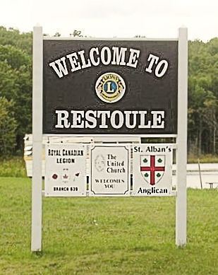
Restoule is located on Ontario Highway 534 and is a 9 kilometre drive southeast of Restoule Provincial Park. There is only one way to get into Restoule, and that's on Highway 534 from the east. There's a secondary route from the west from Dokis territory and leads into town on Hawthorne Rd. Entering the village, one can see the main General Store off the highway on the right. The main centre of the community however can be found off Highway 534, across the Restoule River. On this side of the river, there is a Royal Canadian Legion (Branch #639), a Lion's Club, Community Centre, Outdoor Hockey Rink, Play structures, a United Church and an Anglican Church. There is a Pentecostal Corner Gospel Church 5 km east of the village at the intersection of Hwys. 524 and 534. There are several housekeeping cottages, camps and lodges.
Cottages dot the shores of both Restoule Lake north of town and Commanda Lake south of town. Also dotting the rolling countryside are various farms. Most of all, the scenery is dominated by majestic forests on the Canadian Shield.
Restoule residents elect three local government organizations to manage their affairs: The Restoule Local Services Board, Patterson Township Local Roads Board and Restoule Sanitary Landfill Committee.
Restoule has broadband Internet access and cell phone service provided by Bell. As of Apr. 30, 2014 Rogers has not co-located on the Bell tower so there is little to no Rogers coverage.
Etymology
This place in Parry Sound District, 36.1 km west of Powassan, was named in 1878 after Ojibwa chief Joseph Restoule, who was still alive when the postmaster provided details to the chief geographer of Canada in 1905.
Other places of the same name in Ontario
There is also a geographic Restoule Township in Algoma District, Ontario, on the Algoma Central Railway.
Demographics
According to the Canada 2016 Census:
Politics
Politically, Restoule, as with most of rural Parry Sound District leans Conservative.
Election results in Restoule
Federal
Provincial