
- elevation 222 m (728 ft) - elevation 187 m (614 ft) | - location Hardy Township | |
 | ||
- location | ||
Restoule river
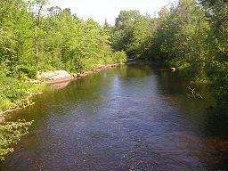
The Restoule River is a river in Parry Sound District in Central Ontario, Canada. It rises at Commanda Lake in geographic Patterson Township at the community of Restoule. It then flows north into Restoule Lake then north into Stormy Lake at Restoule Provincial Park, at the end of Ontario Highway 534. It then heads west into geographic Hardy Township to its mouth at the French River.
Contents
- Restoule river
- Map of Restoule River Parry Sound Unorganized Centre Part ON Canada
- Water spirits dancing at restoule river
- Tributaries
- References
Map of Restoule River, Parry Sound, Unorganized, Centre Part, ON, Canada
The total length of the river is about 40 kilometres (20 mi). From Lennon Lake in Hardy Township to the mouth, the river forms a boundary of the Dokis 9 First Nations reserve.
Water spirits dancing at restoule river
Tributaries
References
Restoule River Wikipedia(Text) CC BY-SA