
Country Canada Time zone Eastern (EST) (UTC-5) Population 608,124 (2011) | Established 1792 (County) Elevation 91.3 m (299.5 ft) Area 2,523 km² | |
 | ||
Established January 1, 1974 (Regional Municipality) Colleges and Universities Durham College, University of Ontario Institute o, CDI College - Ajax Points of interest | ||
The Regional Municipality of Durham, informally referred to as Durham Region, is a regional municipality located in Southern Ontario east of Toronto and the Regional Municipality of York, forming the east end of the Greater Toronto metropolitan area. It has an area of approximately 2,500 square kilometres. The regional government is headquartered in Whitby.
Contents
- Map of Durham Regional Municipality ON Canada
- Subdivisions
- Local government
- History
- Climate
- Services
- Economy
- Automobile and other industries
- Shopping
- 400 series freeways
- Other highways
- Public transportation
- Air Travel
- Education
- Travel region
- References
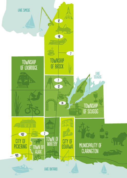
Map of Durham Regional Municipality, ON, Canada
The southern portion of the region, on Lake Ontario is primarily suburban in nature, forming the eastern end of the 905 belt of suburbs around Toronto. The northern area comprises rural areas and small towns. The city of Pickering, town of Ajax and the township of Uxbridge are considered part of Toronto's Census Metropolitan Area, while the communities of Oshawa, Whitby, and Clarington are part of the Oshawa's Census Metropolitan Area.
Subdivisions
Durham Region consists of the following municipalities:
It also contains one First Nations reserve: Mississaugas of Scugog Island First Nation.
West Rouge (including Port Union) was transferred from Pickering over to Scarborough, Ontario prior to creation of Durham Region in 1974 and now part of Toronto.
Local government
History
The Region of Durham was established in 1974 as one of several new regional governments in the Province of Ontario, primarily in fast-growing urban and suburban areas. It encompasses areas that had been part of Ontario County and the United Counties of Northumberland and Durham, and was the culmination of a series of studies into municipal governance in the "Oshawa-Centred Region" that had begun in the late 1960s. The boundaries of the region were different than had been anticipated and from those announced in late 1972; for example, it was widely expected that Pickering would be annexed to Metropolitan Toronto, which residents had expressed preference for in a ballot question. In addition, the region was proposed to extend further east to include Hope Township and the town of Port Hope, and did not include the northern townships of Scott, Brock and Thorah.
Climate
Under the Köppen climate classification, the Durham Region has a humid continental climate (Köppen Dfb).
Services
The regional government, within its geographic area, has sole responsibility for the following:
The region also provides services in:
Local municipalities have responsibility for:
Economy
Youth unemployment is a major issue in the region: at 23% by the Durham Workforce Authority in 2013, it is 17% higher than the provincial average.
Major employers include General Motors of Canada, Ontario Power Generation, Lakeridge Health, Durham District School Board, Durham College, University of Ontario Institute of Technology, and many smaller component and transportation firms supplying the automotive industry.
Automobile and other industries
Durham Region is a major centre of the Canadian automobile industry. Oshawa is the Canadian headquarters of General Motors and home of GM's largest plant in North America. In addition, the Canadian headquarters of Volkswagen is located in the region, BMW was located in the region until moving to Richmond Hill in 2010. The worldwide recession and spike in oil prices resulted in large-scale layoffs at GM beginning in 2008, along with the closure of the Oshawa Truck plant in 2009. This dramatically reduced employment levels at GM, and also resulted in significant employment losses and closures in the auto parts industry. While a number of models are currently produced in Oshawa, concerns remain about GM's long-term future as a manufacturer in Canada as no production is currently slated for Oshawa beyond 2016.
Ontario Power Generation (OPG) is also a major employer in the region. OPG is Canada's largest owner of nuclear power plants with responsibility for operating the Pickering A, Pickering B, and Darlington nuclear generating stations, all of which are located in Durham Region.
Shopping
Major shopping centres located in Durham Region include:
400-series freeways
Other highways
Note: This is the only region of the Greater Toronto Area where the Trans Canada Highway passes through. The TC's Central Ontario Route enters from the northeast at Manilla along Highway 7, makes an abrupt turn near Sunderland onto Highway 12 heading north towards Beaverton and the northern regional boundary.
Public transportation
Public transit in the Region is operated by Durham Region Transit, which was formed in January 2006 when the five preexisting municipal public transit systems in the region were merged under the Region's administration.
In addition, GO Transit provides the following services within the Region:
Air Travel
Although small airports such as Oshawa Airport exist in Durham Region, the main airport serving the region is Toronto Pearson International Airport.
Education
The Durham District School Board operates all English-language secular public schools within Durham Region, except for those schools within Clarington, which are part of the Kawartha Pine Ridge District School Board. This is a holdover from the pre-1974 structure in which the area now forming Clarington was part of Durham County, while the other municipalities were part of Ontario County.
The Durham Catholic District School Board operates the separate English-language public Catholic school system within Durham Region, again with the exception of schools in Clarington, which are part of the Peterborough Victoria Northumberland and Clarington Catholic District School Board.
Neither school board is an operating division of the regional government. Instead, as is true of all school boards in Ontario, they are separate entities with distinct but overlapped service areas. Elected public trustees responsible for their operation.
French-language school boards serving the municipality include the Conseil scolaire Viamonde and the Conseil scolaire de district catholique Centre-Sud.
Durham Secondary Academy and Middle School offers private elementary and secondary education for students in the Region of Durham.
The region also is home to the University of Ontario Institute of Technology (UOIT), Ontario's fastest growing university, Durham College, and Trent University Durham (Trent University's main campus is in Peterborough). The UOIT and Durham College main campuses are located in North Oshawa. Durham College also has a satellite campus in Whitby, and UOIT has one in Downtown Oshawa.
Travel region
Durham Region lies within the Central Counties of Ontario, a tourism-related association.