
Country Canada Time zone Eastern (EST) (UTC−5) Local time Friday 6:13 AM | Elevation 83.8 m (274.9 ft) Area code(s) 905 / 289 / 365 Province Ontario | |
 | ||
Weather 2°C, Wind E at 29 km/h, 93% Humidity Points of interest Lake Ontario, Beachfront Park, Petticoat Creek, Waterfront Trail | ||
Pickering (2011 population 88,721) is a city located in Southern Ontario, Canada, immediately east of Toronto in Durham Region. It was settled by primarily ethnic British colonists, starting in the 1770s. Most of its growth has come since the end of World War II, and it has received immigrants from around the globe.
Contents
- Map of Pickering ON Canada
- Early period
- European settlement
- Twentieth century
- Twenty first century
- Geography
- Demographics
- Communities
- Economy
- Transportation
- Malls
- Nautical Village
- Government
- Emergency services
- Education
- Notable people
- In film
- Art
- References
Map of Pickering, ON, Canada
Early period
This was Aboriginal territory for thousands of years. The Wyandot (called the Huron by Europeans), who spoke an Iroquoian language, were the historic people living here in the 15th century. Archeological remains of a large village have been found here, known as the Draper Site. Later, the Wyandot moved northwest to Georgian Bay, where they established their historic homeland. There they encountered French explorers in the early 17th century, followed by missionaries and fur traders.
The first recorded history of this area was made in 1669, when French Jesuit missionary François de Salignac de la Mothe-Fénelon noted reaching what he called the Seneca (more likely Onondaga) village of Gandatsetiagon, on the shores of Frenchman's Bay (for whom it would be named for). The Onondaga (and the Seneca) were among the Five Tribes of the Iroquois Confederacy. The Onondaga (and other Iroquois) generally occupied territory to the south and west of Lakes Ontario and Erie in present-day New York, extending into Pennsylvania and the Ohio Valley, where they maintained hunting grounds. (The Seneca were located farther west, near Seneca Lake among the Finger Lakes. Fenelon wintered at the village and started missionary work with this people.)
European settlement
The British took over Canada following defeat of the French in the Seven Years' War, known in the North American front as the French and Indian War. They likely completed survey of the township about 1776; British colonial settlers were steadily migrating into the area from eastern areas of Canada. The town was named after Pickering, North Yorkshire.
In the 1813 census, Pickering had 180 residents —40 more than neighbouring Scarborough. A large influx of Quaker immigrants from the eastern United States arrived in the early 1810s. The main thoroughfare at this time was the Kingston Road, which cut through the south of the township on its way from York (now Toronto) east to Kingston.
Pickering was represented in the Mackenzie Rebellion of 1837. One of the leaders, Peter Matthews, had formerly been one of the most prominent members of the community.
Twentieth century
In 1941, the southeastern portion of the township became the independent town of Ajax. Ontario County, Ontario became Durham Region in 1974, and some of the town lines were modified. As a result, one of the population centres of the original township, Pickering Village, became part of Ajax, along with its secondary school.
Twenty-first century
Pickering has planned a downtown intensification program which includes new condominium developments around the Pickering GO station and Pickering Town Centre.
Geography
Toronto, Markham, and Rouge Park border Pickering on the west; Ajax borders Pickering on the east; and Lake Ontario forms Pickering's southern boundary.
Demographics
Pickering has experienced rapid growth in the post-war period in the second half of the twentieth century. Toronto's continuing growth led to more people moving into Pickering. Between 1996 and 2001, the municipality experienced a growth rate of 10.3 percent (78,989 people to 87,139). Population growth has slowed considerably in recent years, growing only slightly between the 2001 and 2011 census.
The low population growth is mainly due to the city's development restrictions on land in the northern portion of its area, as they tried to contain sprawl. Negotiations are ongoing to permit development in this area. Consequently, the city has estimated that by 2031, Pickering will be home to 190,000 residents. The province of Ontario has designated Pickering as one of two municipalities in Durham Region that are urban growth centres, planned to receive more development and population.
According to the 2011 Census, English is the mother tongue of 78.6% of the population, followed by Urdu (1.5%), Tagalog (Pilipino, Filipino) (1.5%) and Italian (1.4%), reflecting 20th century and later immigration.
Communities
The southern part of the city is mainly suburban, with industrial areas restricted to the area around Pickering Nuclear Generating Station. Most of the suburban areas were built as subdivisions after World War II, starting in the area around Frenchman's Bay. Prior to the war, the few suburban areas in the township were the communities of Dunbarton, Fairport Beach, Liverpool Market, and Rouge Hill. Squires Beach, located by the lakeshore in the southeast part of the city, is now a ghost town.
The northern part of the municipality is mainly rural, primarily used for agricultural purposes. However, a number of residential developments are found in this area, and the locally controversial Seaton area also falls within this part of the city. The primary rural communities in Pickering are Claremont, Brougham, and Whitevale; a number of smaller communities exist throughout northern Pickering such as Greenwood. The abandoned ghost town of Altona is located there. Cherrywood, another hamlet in Pickering, is one of the few areas that are protected within the Greenbelt.
Economy
Pickering is home to the Pickering Nuclear Generating Station, an eight-reactor facility with a capacity of 4,120 megawatts. The first station, Pickering A, opened with four reactors in 1971. Ontario Power Generation, the plants' operator, is the largest single employer in the city. In 2001, the wind-powered OPG 7 Commemorative Turbine was opened on the generating station site. The nuclear power plant is expected to start decommissioning in 2024.
A number of manufacturers are also located in the city. Major employers include Yorkville Sound (audio equipment), the Canadian headquarters of Purdue Pharma (pharmaceuticals and health & beauty products), Hubbell Canada (electrical equipment), PSB Speakers - Lenbrook (stereo equipment) and Eco-Tec Inc. (industrial water purification and chemical recovery systems).
Pickering is a founding member of the Durham Strategic Energy Alliance or DSEA. The nucleus of the DSEA is primarily Pickering businesses, such as Ontario Power Generation, Veridian, Siemens/Trench, Tetra Tech WEI, AECL, Intellimeter, Areva and Eco-Tec Inc.
The city is the location of the head office of the Municipal Property Assessment Corporation. MPAC performs value assessment for property tax purposes for all municipalities in Ontario. In 2012 Search Engine People, Canada's largest Internet-marketing company, moved to Pickering's downtown.
In 2006, Profit magazine recognized Pickering as one of the top 10 cities in Canada for growing a business.
In 2013, the Region of Durham released its Business Count (Employment Survey), which indicated that Pickering has the most jobs amongst Durham Region municipalities, with 29,000+ positions. This figure represents a near 1/3 ratio of jobs to residents.
With the implementation of Seaton and downtown intensification, the Province of Ontario's planning sees the additional creation of 40,000 new jobs for Pickering over the next two decades.
Transportation
Transit service began in Pickering with the Bay Shores dial-a-bus, which began in 1970-1973. In 2001 Pickering Transit merged with former Ajax Transit to form the Ajax-Pickering Transit Authority (APTA). In 2006, the regional transit system Durham Region Transit took over operations in the Durham Regional Municipality.
The Pickering GO station offers public rail transit on an east-west axis. In 2012, Pickering's landmark bridge opened - connecting the Pickering GO station to the City's downtown core.
Durham Regional Roads serve the city, north and south. To find more about Durham Regional Roads, go to this link: Durham Regional Roads . Ontario Highway 401 runs near the south end of Pickering and Ontario Highway 407 ETR runs through the mid-north of the City.
A new airport is scheduled to be built and be operational by 2027. It will be built alongside lands for the future Rouge National Park.
Malls
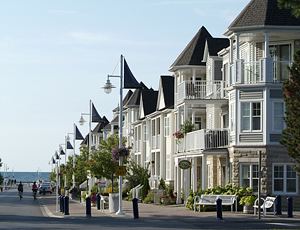
Nautical Village
This picturesque popular summer tourist destination by the lake and Frenchman's Bay features free musical entertainment at Millennium Square, a playground and waterfeature for children, a great boardwalk along the waterfront as well as cafes, restaurants, shops and an art gallery. Part of the Waterfront Trail in Pickering, on weekends between May and September, it features "Sundays on the Porch" where vendors are provided a location in front of a local business, that is closed on Sundays, to show and sell their wares in quaint Nautical Village located by the lake during peak season.
Government
The city council consists of a mayor, three regional councillors, and three city councillors. The mayor and regional councillors sit on the council and also represent the city at Durham Regional Council. The city councillors sit on city council only. Pickering is divided into three wards, with one city councillor and one regional councillor representing each ward.
The current mayor, Dave Ryan, has held the mayoralty since 2003.
Emergency services
Police services in Pickering are provided by the Durham Regional Police from a division office located in the eastern section of the city. Officers from this location also patrol Ajax. Pickering Fire Services operates from four stations with a force of all full-time firefighters. Claremont Fire Hall is now fully staffed by full-time firefighters 24 hours a day, seven days a week. Ambulance/emergency medical services are provided by Durham Region.
Education
Pickering is served by the Durham District School Board, the Durham Catholic District School Board, the Conseil scolaire Viamonde and the Conseil scolaire de district catholique Centre-Sud. As of early 2007, the public board operates 17 elementary schools and two secondary schools, Dunbarton High School and Pine Ridge Secondary School (Pickering High School was previously located in Pickering, but was transferred to Ajax when the city boundaries were changed). The Catholic board runs eight elementary schools and one secondary school, Saint Mary Catholic Secondary School. The French public school board operates École Ronald-Marion, which serves both elementary and secondary students.
Blaisdale Montessori School, a private school chain, has several locations throughout Pickering serving children from preschool age to grade 8. There is also a private elementary and junior high school there called Montessori Learning Centre. Also serving the Durham Region is Durham Secondary Academy & Middle School, an inspected private high school and middle school for grades 5 to 12.
In September 2012, the Durham College/Centennial College Joint Learning Site opened at the north terminus of the pedestrian bridge. The Joint Learning Site offers primarily graduate certificate programs, with a number of complementary courses and classes. At the time of its opening, it was the only public post-secondary institution in the Province of Ontario with a direct connection to public transit.