
Time zone BST (UTC+6) | ||
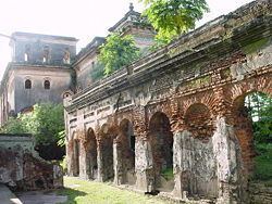 | ||
Colleges and Universities University of Rajshahi, Rajshahi University of Engine, Rajshahi Medical College, Institute of Health Technolo, Godagari School & College Points of interest Varendra Research Museum, Puthia Rajbari, Rajshahi Central Zoo, Padma Garden, Rajshahi Central Zoo Gate‑1 | ||
Rajshahi District (Bengali: রাজশাহী জেলা) is a district in north-western Bangladesh. It is a part of the Rajshahi Division. The metropolitan city of Rajshahi is in Rajshahi District.
Contents
- Map of Rajshahi District Bangladesh
- Geography
- Rivers
- Upazilas
- Communications
- The Silk City
- Points of interest
- References
Map of Rajshahi District, Bangladesh
Geography
Rajshahi district is bounded by Naogaon District to the north, Natore District to the east, and Chapai Nababganj District and the river Padma to the south.
Rivers
There are ten rivers in this district, totaling 146 km in length. The main river is Padma River (Ganges). Some others are Mahananda, Baral and Barnai river.
Upazilas
Sub-district or upazilas and thanas of Rajshahi are
Communications
Rajshai district has well organized internal communication as well as connection to other parts of the country. There are 96 metalled roads with a total length of about 1270 km, 108 semi-metalled roads of about 546 km length, and six railways of about 63 km total length.
The Silk City
Rajshahi Metropolitan. Its widely known as Silk City of Bangladesh, the National Silk Board (In Bengali : Jatio Resham Board) is situated at Rajshahi. Also an Inter-City train is named Silk City after Rajshahi. The train communicates Rajshahi to Dhaka, the capital city of Bangladesh. Rajshahi is famous in Bangladesh for producing Mango and Silk.