
Peak Phu Thap Buek Width 110 km (68 mi) E/W Elevation 1,794 m | Length 190 km (120 mi) N/S | |
 | ||
Parent range Luang Prabang Range (western section) Mountains | ||
Phetchabun mountains in northeast thailand
The Phetchabun mountains (Thai: ทิวเขาเพชรบูรณ์, Thio Khao Phetchabun, [tʰiw kʰǎw pʰét.tɕʰa.buːn]) are a mountain massif in Phetchabun, Phitsanulok, Loei and Chaiyaphum Provinces, Thailand. It consists of two parallel mountain chains, with the valley of the Pa Sak River in the middle.
Contents
- Phetchabun mountains in northeast thailand
- Phu tub berk phetchabun mountains northern thailand
- Geography
- History
- Protected areas
- References
The strange rock formations of Phu Hin Rong Kla and fields where the Siam tulip flower (Curcuma alismatifolia), known as dok krachiao (ดอกกระเจียว) in Thai, grows wild are some of the characteristics of the Phetchabun Mountains.
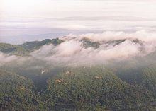
Phu tub berk phetchabun mountains northern thailand
Geography
The mountain system as a whole is named after the city of Phetchabun which lies within the mountainous area. To the south and southeast lie the Dong Phaya Yen Mountains. Both sections of the Phetchabun massif are parallel and of a similar length, extending in a roughly north-south direction. The western range is a prolongation of the southern end of the Luang Prabang Range. The eastern range separates the broad Chao Phraya river basin of central Thailand from the Khorat Plateau of Isan. The northward-flowing Loei River, a tributary of the Mekong, has its sources in the eastern range.
The southern limit of the Phetchabun massif is not clearly defined, roughly beginning south of the 16th parallel north where both ranges become a group of scattered mountains of lesser height, rarely surpassing 800 m, extending southwards. The eastern mountain chain is mentioned as the Phang Hoei Range in some geographical works, a name that encompasses the whole northern section of the Dong Phaya Yen mountain system, for Khao Phang Hoei is a 1,008 m high summit west of Chaiyaphum town, beyond the southern end of the Phetchabun Range proper in the northern Dong Phaya Yen.
The highest elevation of the Phetchabun mountains is 1,794 m high Phu Thap Buek. Other important peaks are Khao Nam Ko Yai, Phu Kradueng, Phu Luang, Phu Ruea, and Phu Lom Lo.
Geologically, the mountains consist of limestone, interfused with slate and sandstone. A few igneous rocks are also found: granite, basalt and porphyry.
History
Historically the long mountainous system of the Phetchabun-Dong Phaya Yen-Sankamphaeng formed a barrier between Isan and the Central Plain. Until recently few roads crossed the system.
During the period between 1968-1982 the area around 1,143 m high Khao Kho (เขาค้อ) and Phu Hin Rong Kla became an occasional battleground. At that time insurgents of the Communist Party of Thailand established their base in hidden mountain locations and fought skirmishes against the Thai Army.
Protected areas
Several protected areas, including national parks, forest parks and wildlife reserves are located in these mountains. In 2005 these were accepted by the UNESCO as a possible future addition to the World Heritage list. Besides these protected areas, some forest parks are also located within the area of the range: