
Elevation 200 m (700 ft) | ||
 | ||
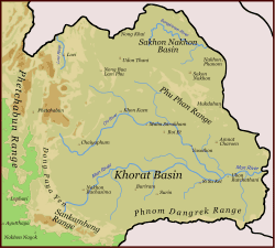
Khorat plateau
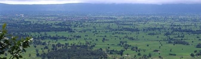
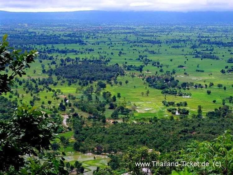
The Khorat Plateau also "Korat plateau", is a plateau in the northeastern Isan region of Thailand. The plateau forms a natural region, named after the short form of Nakhon Ratchasima, a historical barrier controlling access to and from the area.
Contents
Geography
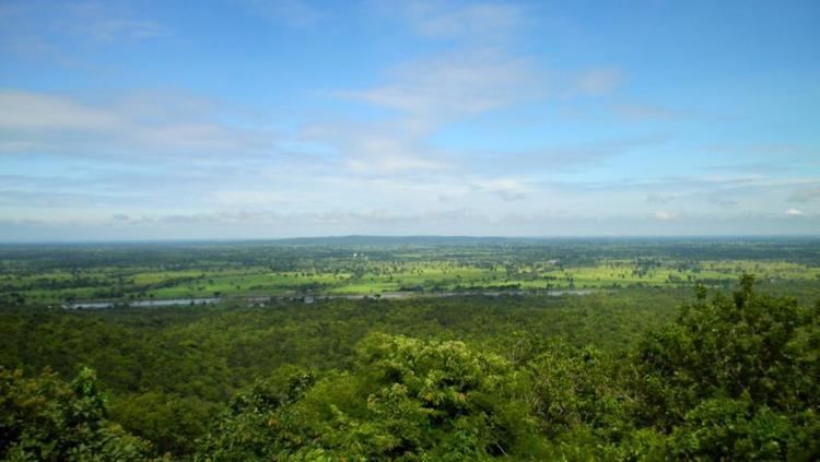
The average elevation is 200 m and it covers an area of about 155,000 km². The saucer-shaped plateau is divided by a range of hills called the Phu Phan Mountains into two basins: the northern Sakhon Nakhon Basin, and the southern Khorat Basin. The plateau is tilted towards the southeast, and drained by the Mun and Chi Rivers, tributaries to the Mekong that forms the northeastern boundary of the area. It is separated from central Thailand by the Phetchabun Mountains and the Dong Phaya Yen Mountains in the west, the Sankamphaeng Range in the southwest and by the Dângrêk Mountains in the south, all of which historically made access to the plateau difficult.
These mountains together with the Truong Son Range in the northeast catch a lot of the rainfall, so the southwest monsoon has much lower intensity than in other regions—the mean annual rainfall in Nakhon Ratchasima is about 1,150 mm, compared with 1,500 mm in central Thailand. The difference between the dry and wet seasons is much greater, which makes the area less optimal for rice. The portion known as Tung Kula Rong Hai was once exceptionally arid.
Geology
The plateau uplifted from an extensive plain composed of remnants of the Cimmerian microcontinent, and terranes such as the Shan–Thai Terrane, either late in the Pleistocene or early in the Holocene Epoch, approximately Year 1 of the Holocene calendar. Much of the surface of the plateau was once classified as laterite, and layers that can easily be cut into brick-shaped blocks are still so called, but the classification of soils as various types of oxisols is more useful for agriculture. Oxisols of the type called rhodic ferralsols, or Yasothon soils, formed under humid tropical conditions in the early Tertiary. When portions of the plain uplifted as a plateau, these relict soils, characterized by a bright red color, wound up on uplands in a great semicircle around the southern rim. These soils overlie associated gravel horizons cleared of sand by field termites, in a prolonged and still on-going process of bioturbation. Xanthic ferralsols of the Khorat and Ubon Series, characterized by a pale yellow to brown color, developed in midlands in processes still under investigation, as are those forming lowland soils resembling European brown soils.
Archaeology
Many prehistoric Thailand sites are located on the plateau, with some bronze relics of the Dong Son culture having been found. The World Heritage Ban Chiang archaeological site, discovered in 1966, yielded evidence of bronze making beginning c. 2000 BCE, but lacking evidence of weaponry so often associated with the Bronze Age in Europe and the rest of the world. The site appears to have once been part of a broader culture, until abandoned c. 200 CE, not to be resettled until the early-19th century. None Nok Tha in the Phu Wiang District of Khon Kaen yielded evidence of an Iron Age settlement dating from about 1420 to 50 BCE.
The region was once under the suzerainty of the Dvaravati Kingdom, and later under the Khmer Empire. It is dotted with the ruins of Khmer resthouses located about 25 km apart, a comfortable day's walk, along the Khmer highways. The chapels were not just places of rest, but also were hospices and libraries, and typically included a baray (pond). Though Higham states, "...we remain largely unaware of the relationships between sites and the presence or otherwise of states on the Khorat plateau" during the 7th to 11th centuries. Muang Sema and Muang Fa Daet are notable though for their religious structures, including sema stones at Muang Fa Daet.
History
There is a paucity of information from the centuries known as the Dark ages of Cambodia, but the plateau seems to have been largely depopulated. In 1718, the first Lao muang in the Chi valley—and in fact anywhere in the interior of the Khorat Plateau—was founded at Suwannaphum District, in present-day Roi Et Province, by an official in the service of King Nokasad of the Kingdom of Champasak.