Area 307 km² Established 1984 | Phone +66 55 233 527 Number of visitors 131,472 | |
 | ||
Location Loei, Phitsanulok and Phetchabun Provinces, Thailand Address Highway 2331, Tambon Noen Phoem, Nakhon Thai District, Chang Wat Phitsanulok 42120, Thailand Similar ร้านรังทอง, บ้านร่องกล้า, Lan Hin Pum, Phu Tubberk | ||
Phu hin rong kla national park in phitsanulok
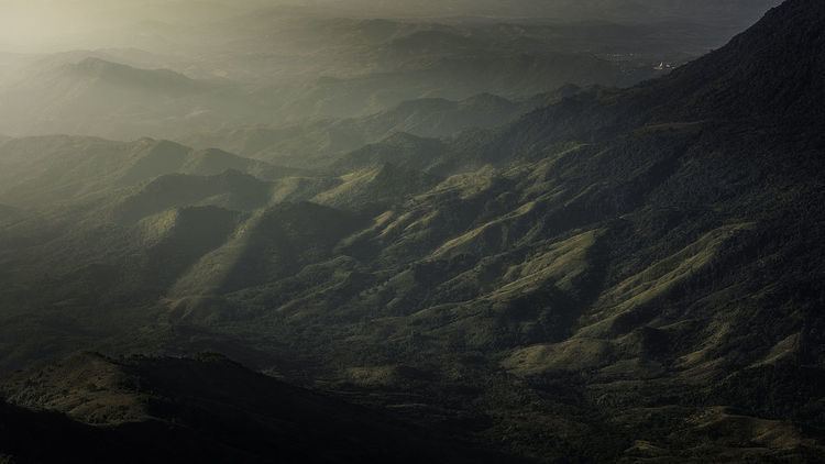
Phu Hin Rong Kla National Park is a national park located in the Loei, Phitsanulok and Phetchabun Provinces of Thailand. The protected area is located in the forested mountains of the Luang Prabang Range close to the border with Laos and is part of the Luang Prabang montane rain forests ecoregion.The park is the base of operations of the long fight of Thai combatant in communist war of Thailand.
Contents
- Phu hin rong kla national park in phitsanulok
- Phu hin rong kla national park
- TopographyEdit
- HistoryEdit
- ClimateEdit
- ForestEdit
- Dry Dipterocarp ForestEdit
- Hill evergreen ForestEdit
- Pine ForestEdit
- Animal speciesEdit
- Rock formationsEdit
- Effect of human presenceEdit
- References
Phu hin rong kla national park
TopographyEdit
The park landscape is generally dominated by mountainous terrain. Phu Thap Boek, also known as Phu Man Khao, the highest mountain of the Phetchabun Range, is located within the park area. The northern part of the park stretches to the border with Laos. The southern part of the park extends into the Phetchabun Province. Mountain peaks include Phu Phang Ma, Phu Lom Lo and Phu Hin Rong Kla. The second tallest is Phu Lomlo at an elevation of 1,664 meters. Within the park are the sources of the Mueat Don and Luang Yai Rivers.
HistoryEdit
In 1968 - 1982, Phuhinrongkla or Phurongkla is a dense jungle and the red area because it is a battle field between Communist of Thailand party and Security Forces. At the end of the fight, there was no winner because the Security Force announced a temporary policy. They gave a chance to students and people who escaped into the jungle come back to the city and help them develop the country.
ClimateEdit
The park is generally cool all year round, with temperatures rarely rising above 25° Celsius. The temperature occasionally drops below freezing.
ForestEdit
The park has mixed deciduous, dry dipterocarp, hill evergreen and pine forests.
Dry Dipterocarp ForestEdit
The lower Mekong Dry Forest Ecoregion is characterized by a mosaic of habitats. The main forest type is deciduous forest. On higher quality soils or at higher elevation, areas of mixed deciduous forest and semi-evergreen forest occur. This mosaic of forest type is one of the reasons why such a large quantity and diversity of species are home to this landscape - the diverse forest patches act as key resource areas and refugia for a lot of wildlife.
Deciduous dipterocarp forests typically have an open canopy combined with a grassy understorey. Member of the forest's namesake family Dipterocarpaceae dominate the vegetation. While all other Dipterocarp-trees are evergreen, the six species in the dry forest are the only ones that lose their leaves during the dryer months of November to April. This is likely to be an adaptation to the region's climate with its strong, extended wet and dry seasons - shedding the leaves decreases the tree's surface area and reduces the amount of water that the trees lose due to transpiration.
Semi-evergreen forests have a taller and multilayered forest structure than deciduous dipterocarp forests. While such forest to lowland evergreen rain forest, they grow in areas with lower and more seasonal rainfall and are characterized by lower species diversity. Bamboos are common in the semi-evergreen forests of Cambodia's Eastern Plains Landscape, especially along seasonal waterways and after disturbance. Within the Dry Forest Ecoregion, semi-evergreen forest patches are essential in providing shelter to large mammals and key resources to many species.
Interspersed within these forests are seasonally inundated wetlands; natural clearings that provide sources of food and water for a wide variety if wildlife, especially during the latter stages of the dry season. These wetland, along with scattered permanent pools along seasonal river beds, form a crucial resource network throughout the Dry Forest ecoregion, especially in the Eastern Plains and help o maintain many of its ecological processes.
Hill evergreen ForestEdit
This type of forest is less dense than the tropical evergreen forest because it has less large trees. This type of forest too is green all year round. The climate is quite cool because it is found at high altitudes. the hill evergreen forest is very important to the preservation of water sources.
Trees are mainly shrubs mixed with some pines. Smaller plants the forest include ground orchids and other tropical plants such as wild roses, violets and lilacs. In addition there are small plants that grow on the larger trees such as moss and orchids.
Pine ForestEdit
There is only pine in the forest which is pine two leaves and three leaves. Normally pine forest grow lower than rainforest or same level as rainforest. In dry area can grow as well, but more than 200 - 1800 meters from sea level. In Thailand pine forest mostly growth in Northern and East Northern part.
Animal speciesEdit
At the present, humans come and settle down so there no wild animals in the national park, but there are some species of bird in the national park.
Rock formationsEdit
The park contains Lan Hin Taek, natural rock formations covered with orchids, ferns, moss, lichens and seasonal flowers.
Effect of human presenceEdit
Much of the forest was damaged and much of the wildlife was killed or fled to safer areas during a period when the region was used as a battlefield between the Thai government and the communists.
