
 | ||
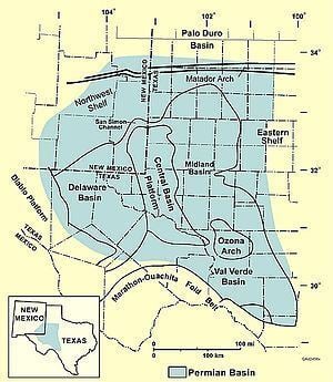
The Permian Basin is a sedimentary basin largely contained in the western part of the U.S. state of Texas and the southeastern part of the U.S. state of New Mexico. It reaches from just south of Lubbock, to just south of Midland and Odessa, extending westward into the southeastern part of New Mexico. It is so named because it has one of the world's thickest deposits of rocks from the Permian geologic period. The greater Permian Basin comprises several component basins: of these, Midland Basin is the largest, Delaware Basin is the second largest, and Marfa Basin is the smallest. The Permian Basin extends beneath an area approximately 250 miles (400 km) wide and 300 miles (480 km) long.
Contents
- The Delaware Basin
- The Midland Basin
- Central Basin Platform
- Eastern and Northwest Shelves
- San Simon Channel
- Sheffield Channel
- Hovey Channel
- Horseshoe Atoll
- Depositional history
- Lower Paleozoic Upper Cambrian to Mississippian
- Upper Mississippian Lower Permian
- Upper Permian
- Generalized facies tracts of the Permian Basin
- Lowstand systems tract
- Transgressive systems tract
- Highstand systems tract
- Tectonic history
- Lower Paleozoic passive margin phase late Precambrian Mississippian 850310 Mya
- Collision phase late Mississippian Pennsylvanian 310265 Mya
- Permian Basin phase Permian 265230 Mya
- Hydrocarbon plays
- Counties of the Permian Basin
- References
The Permian Basin gives its name to a large oil and natural gas producing area, part of the Mid-Continent Oil Producing Area. Total production for that region up to the beginning of 1993 was over 14.9 billion barrels (2.37×10⁹ m3). The towns of Midland and Odessa serve as the headquarters for oil production activities in the basin.
The Permian Basin is also a major source of potassium salts (potash), which are mined from bedded deposits of sylvite and langbeinite in the Salado Formation of Permian age. Sylvite was discovered in drill cores in 1925, and production began in 1931. The mines are located in Lea and Eddy counties, New Mexico, and are operated by the room and pillar method. Halite (rock salt) is produced as a byproduct of potash mining.
The Delaware Basin
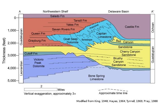
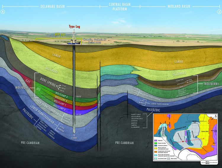
The Delaware Basin is largest lobe of the two major lobes of the Permian Basin within the foreland of the Ouachita–Marathon thrust belt separated by the Central Basin Platform. The basin contains sediment from the Pennsylvanian, Wolfcampian, Leonardian, and early Guadalupian times. The eastward dipping Delaware basin is subdivided into several formations (Figure 2) and contains approximately 25,000 feet (7,600 m) of laminated siltstone and sandstone. Aside from clastic sediment, the Delaware basin also contains carbonate deposits originating from the Guadalupian times when the Hovey Channel allowed access from the sea into the basin.
The Midland Basin
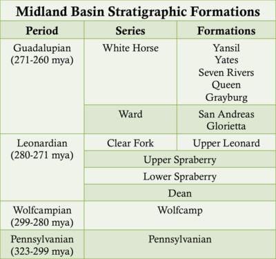
The westward dipping Midland Basin is subdivided into several formations (Figure 4) and is composed of laminated siltstone and sandstone. The Midland Basin was filled via a large subaqeuous delta that deposited clastic sediment into the basin. Aside from clastic sediment, the Midland basin also contains carbonate deposits originating from the Guadalupian times when the Hovey Channel allowed access from the sea into the basin.
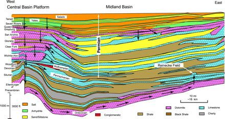
Central Basin Platform
The Central Basin Platform (CBP) is a tectonically uplifted basement block capped by a carbonate platform. The CBP separates the Delaware and Midland Basins and is subdivided into several formations (Figure 5) and is composed of carbonate reef deposits and shallow marine clastic deposits.
Eastern and Northwest Shelves
The Eastern and Northwestern Shelves are composed of shelf edge reefs and shelf carbonates flanking the Delaware and Midland Basins that grade up-dip into siltstones and evaporites. The Eastern and Northwestern Shelves are subdivided into the San Andreas, Grayburg, Queen Seven Rivers, Yates, and Tansil formations.
San Simon Channel
The San Simon Channel is a narrow syncline that separated the Central Basin Platform from the Northwestern Shelf during Leonardian and Guadalupian times.
Sheffield Channel
The Sheffield Channel separated the southern margin of the Midland Basin from the southern shelf and the Ouchita-Marathon thrust-belt during Leonardian and Guadalupian times.
Hovey Channel
The Hovey Channel is a topographical low located on the southern edge of the Delaware Basin, allowing access to the Panthalassa sea during Guadalupian times.
Horseshoe Atoll
The Horseshoe Atoll is a westward-tilting arcuate chain of reef mounds 282 kilometres (175 mi) long located in the Midland Basin, consisting of 549 metres (1,801 ft) of limestone accumulated in the Pennsylvanian and 335 metres (1,099 ft) in the Permian, with 15 significant reservoirs from 1,859 metres (6,099 ft) to 3,018 metres (9,902 ft) in depth. The reef complex consists of Upper Pennsylvanian Strawn, Canyon and Cisco limestones, overlain by Lower Permian Wolfcamp sandstones and shales of terrigenous origin prograding northeast to southwest. The first production well, Seabird Oil Company of Delaware No. 1-B J.C. Caldwelll in 1948.
Depositional history
The Permian Basin is the thickest deposit of Permian aged rocks on Earth which were rapidly deposited during the collision of North America and Gondwana (South America and Africa) between the late Mississippian through the Permian.
Lower Paleozoic (Upper Cambrian to Mississippian)
Prior to the breakup of the Precambrian supercontinent and the formation of the modern Permian Basin geometry, shallow marine sedimentation onto to the ancestral Tobosa Basin characterized the passive margin, shallow marine environment.
Upper Mississippian-Lower Permian
The collision of North America and Gondwana Land (South America and Africa) during the Hercynian Orogeny created the Ouachita-Marathon thrust belt and the associated foreland basins, the Delaware and Midland Basins, separated by the Central Basin Platform. The tectonic activity resulted in the distribution of voluminous siliciclastic sediments into the basins during the Early Pennsylvanian. Siliciclastic sedimentation was followed by the formation of carbonate shelves and margins at the basin flanks in the Early Permian.
Upper Permian
After the Hercynian Orogeny, 4 km of sediment filled the rapidly subsiding Delaware and Midland basins. The Midland basin was filled by about 270 mya, as it received the majority of clastic sediment from the Hercynian Orogeny via a subaqueous delta, while the Delaware Basin continued to fill until the late Permian. Sandstones and some deep water, organic rich shales were deposited within the basins while reef carbonates were deposited on the Central Basin Platform and on the shelves of the basins. The extensive reef deposits fringing the Delaware Basin became known as the Capitan limestone. In the later Guadalupian, the Permian sea retreated, and the basins were capped with evaporite deposits, including salts and gypsum. The deep water shales and carbonate reefs of the Delaware and Midland Basins and the Central Basin Platform would be become lucrative hydrocarbon reservoirs.
Generalized facies tracts of the Permian Basin
The Permian basin is divided into generalized facies belts differentiated by the depositional environment in which they formed, influenced by sea level, climate, salinity, and access to the sea.
Lowstand systems tract
Lowering sea level exposes the peritidal and potentially, the shelf margin regions, allowing linear channel sandstones to cut into the shelf, extending beyond the shelf margin atop the slope carbonates, fanning outward toward the basin. The tidal flats during a lowstand contain aeolian sandstones and siltstones atop supratidal lithofacies of the transgressive systems tract. The basin fill during a lowstand is composed of thin carbonate beds intermingled with sandstone and siltstone at the shelf and sandstone beds within the basin.
Transgressive systems tract
These facies results from the abrupt deepening of the basin and the reestablishment of carbonate production. Carbonates such as bioturbated wackstone and oxygen poor lime mud accumulate atop the underlying lowstand systems tract sandstones in the basin and on the slope. The tidal flats are characterized by supratidal faces of hot and arid climate such as dolomudstones and dolopackstones. The basin is characterized by thick carbonate beds on or close to the shelf with the shelf margin becoming progressively steeper and the basin sandstones becoming thinner.
Highstand systems tract
Highstand systems tract facies results from the slowing down in the rise of sea level. It is characterized by carbonate production on the shelf margin and dominant carbonate deposition throughout the basin. The Lithofacies is of thick beds of carbonates on the shelf and shelf margin and thin sandstone beds on the slope. The basin becomes restricted by the formation of red beds on the shelf, creating evaporites in the basin.
Tectonic history
During the Cambrian-Mississippian, the ancestral Permian Basin was the broad marine passive margin Tobosa Basin containing deposits of carbonates and clastics. In the early Pennsylvanian-early Permian the collision of North American and Gondwana Land (South America and Africa) caused the Hercynian Orogeny. The Hercynian Orogeny resulted in the Tobosa basin being differentiated into two deep basins (the Delaware and the Midland Basins) surrounded by shallow shelves. During the Permian, the basin became structurally stable and filled with clastics in the basin and carbonates on the shelves.
Lower Paleozoic passive margin phase (late Precambrian-Mississippian, 850–310 Mya)
This passive margin succession is present throughout the southwestern US and is up to 1.5 kilometres (0.93 mi) thick. The ancestral Permian basin is characterized by weak crustal extension and low subsidence in which the Tobosa basin developed. The Tobosa basin contained shelf carbonates and shales.
Collision phase (late Mississippian-Pennsylvanian, 310–265 Mya)
The two lobed geometry of the Permian basin separated by a platform was the result of the Hercynian collisional orogeny during the collision of North America and Gondwana Land (South America and Africa). This collision uplifted the Ouachita-Marathon fold belt and deformed the Tobosa Basin. The Delaware Basin resulted from tilting along areas of Proterozoic weakness in Tobosa basin. Southwestern compression reactivated steeply dipping thrust faults and uplifted the Central Basin ridge. Folding of the basement terrane split the basin into the Delaware basin to the west and the Midland Basin to the east.
Permian Basin phase (Permian, 265–230 Mya)
Rapid sedimentation of clastics, carbonate platforms and shelves, and evaporites proceeded synorogenically. Bursts of orogenic activity are divided by three angular unconformities in basin strata. Evaporite deposits in the small remnant basin mark the final stage of sedimentation as the basin became restricted from the sea during sea level fall.
Hydrocarbon plays
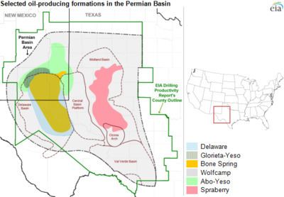
The Permian Basin is the largest petroleum-producing basin in the United States and has produced a cumulative 28.9 billion barrels of oil and 75 trillion cu ft. of gas. Currently, nearly 2 million barrels of oil a day are being pumped from the basin, which still contains an estimated 43 billion barrels of oil and 18 trillion cu ft. of gas. Eighty percent of estimated reserves are located at less than 10,000-foot (3,000 m) depth. Ten percent of the oil recovered from the Permian Basin has come from Pennsylvanian carbonates. The largest reservoirs are within the Central Basin Platform, the Northwestern and Eastern shelves, and within Delaware Basin sandstones. The Primary lithologies of the major hydrocarbon reservoirs are limestone, dolomite, and sandstone due to their high porosities. However, advances in hydrocarbon recovery such as horizontal drilling and hydraulic fracturing have expanded production into unconventional, tight oil shales such as those found in the Wolfcamp formation.
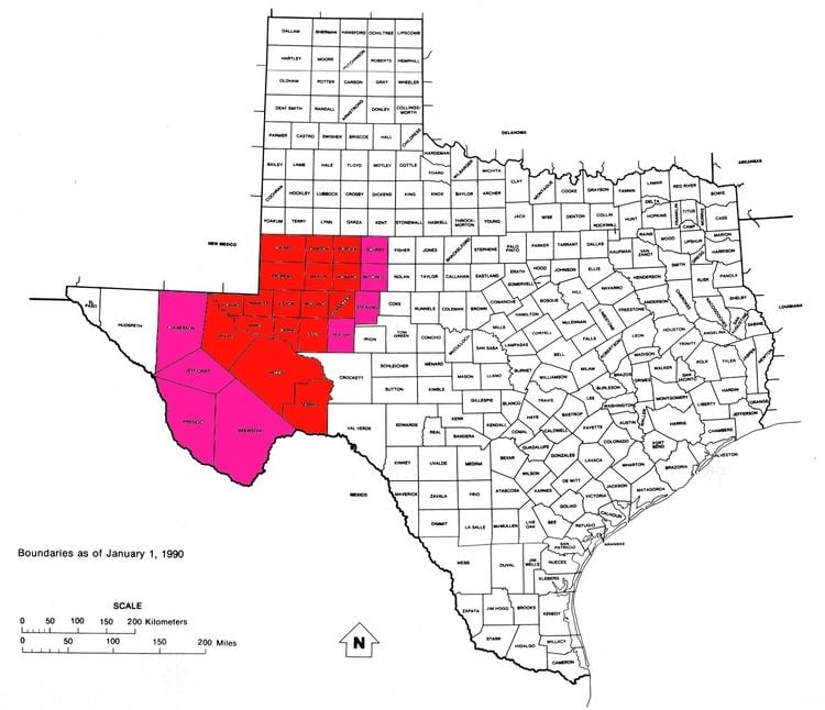
Counties of the Permian Basin
Due to its economic significance, the Permian Basin has also given its name to the geographic region in which it lies. The counties of this region include:
According to the 2008/2009 census, the Permian Basin had a population of 522,568.
Other counties sometimes considered part of the Permian Basin are:
If one includes those counties, then the population of the Permian Basin comes to 577,667.