
PA 458 PA 462 → Constructed 1927 | Length 114.6 km | |
 | ||
Counties | ||
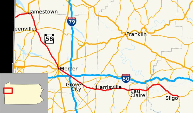
Pennsylvania Route 58 (PA 58) is located in Western Pennsylvania, running 71.2 miles from the Ohio state line 3 miles (4.8 km) west of Jamestown in Mercer County to Sligo in Clarion County.
Contents
- Map of PA 58 Pennsylvania USA
- Mercer County
- Butler County
- Armstrong County
- Clarion County
- History
- Attractions
- References
Map of PA-58, Pennsylvania, USA
Mercer County
PA 58 travels eastward from the Ohio state line in northwestern Mercer County just over 4 miles (6.4 km) to the borough of Jamestown, where, after passing through a low-clearance tunnel beneath an abandoned railroad right-of-way, it intersects with US 322. The two routes join together and continue eastward nearly 0.3 miles (0.48 km) where US 322 leaves northward. PA 58 continues eastward, then turns southeasterly, and about 6 miles (9.7 km) later, joins PA Route 18 just north of the Greenville borough line. The concurrency continues 0.4 miles (0.64 km) into the borough to its junction with PA Route 358. The three routes form a concurrency and head westward – this segment is what is known as a wrong way concurrency, because PA 58 is signed east at the same time that Route 358 is signed west. The concurrency lasts only a quarter mile, and then PA 58 leaves the concurrency, heading south-southeast nearly 15 miles (24 km) to the borough of Mercer. Here, the route first meets the US 19/US 62 concurrency. The three routes form a concurrency south 0.2 miles (0.32 km) to the intersection of PA Route 258. At this complex intersection, the concurrency ends, US 62 continues westward, concurrent with Route 258, US 19 continues south, and Routes 58 and 258 join to the east. Also at this point, the PA 58/PA 258 concurrency is split – eastbound follows S. Diamond St., and westbound follows N. Diamond St. in the middle of town. At the east end of the “square,” the concurrency ends as Route 258 heads southward and PA 58 continues east, then later turns southeast. It crosses both I-80 and I-79 near the interchange of the two interstates, just over 4 miles (6.4 km) from Mercer, and enters the borough of Grove City about 4.5 miles (7.2 km) later. In Grove City, the route intersects with the southern terminus of the PA Route 173/PA Route 208 concurrency, and overlaps with Route 173, continuing southeast. About 0.3 miles (0.48 km) later, the concurrency ends; Route 173 continues south, and PA 58 continues southeast just over 3 miles (4.8 km) to the Butler county line after spending 39 miles in Mercer County.
Butler County
A mile after entering Butler County, PA 58 intersects with PA Route 8 in the borough of Harrisville. The route then travels nearly 7 miles (11 km) to intersect with PA Route 308. The next major intersection is about 4.6 miles (7.4 km) later at PA Route 38 in the borough of Eau Claire. The route then travels nearly 6 miles (9.7 km) before crossing the next county line. The road spends about 18.5 miles in Butler County, serving as the main thoroughfare across the rural northern portion of the county.
Armstrong County
PA 58 has a very short stay in Armstrong County, passing through its extreme northwestern tip. Just 0.4 miles (0.64 km) from the county line, the route intersects with PA Route 268, it then crosses Allegheny River on the Foxburg Bridge, leaving the county just about 0.2 miles (0.32 km) later.
Clarion County
Turning northeasterly, the route passes through the borough of Foxburg upon entering Clarion County, and then heads northeast to enter the borough of St. Petersburg a little over 2 miles (3.2 km) later. Here, PA 58 intersects with the eastern terminus of PA Route 478, and then about 1.9 miles (3.1 km) later, it intersects with the western terminus of PA Route 338 at the village of Alum Rock. The route then winds southeastward 5.3 miles (8.5 km) to intersect with the eastern terminus of PA Route 368 just east of the borough of Callensburg. PA 58 then travels east-southeast nearly 3.5 miles (5.6 km) to its terminus at PA Route 68 in the borough of Sligo The road spends 13 miles in Clarion County.