
Existed: 1969 – present Length 214.4 km | Constructed 1969 | |
 | ||
Counties | ||
Ohio state route 235 going through rural champaign county
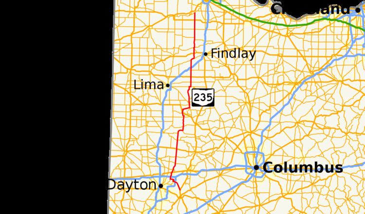
State Route 235 (SR 235) is a 133.2-mile-long (214.4 km) north–south state highway in the western portion of the U.S. state of Ohio. Its southern terminus is at US 68 near the small town of Oldtown just north of Xenia, and its northern terminus is at State Route 65 at the Maumee River nearly 5 miles (8.0 km) east of Grand Rapids.
Contents
- Ohio state route 235 going through rural champaign county
- Map of OH 235 Ohio USA
- Route description
- History
- State Route 69 before 1969
- Future
- References
Map of OH-235, Ohio, USA
Prior to late 1968, it was numbered State Route 69, but was renumbered 235. There are a number of urban legends pertaining to why this renumbering occurred. One is that the number 69 has certain sexual meanings in popular culture, and the signs kept getting stolen. (There were actually numerous cases of people stealing the signs for this route.) Another was that it was too close to Interstate 69 (less than 70 miles (110 km) in some areas) and the state decided to avoid the confusion.
Route description
The portion of SR 235 within Fairborn is designated "Army Specialist Jesse Adam Snow Memorial Highway", in honor of a Fairborn High School graduate who was killed by enemy fire on November 14, 2010 in Afghanistan.
History
State Route 69 before 1969
Future
The Ohio Department of Transportation and the Clark County-Springfield Transportation Coordinating Committee have conducted a SR 235 Corridor Management Study, examining improvements to SR 235 in Bethel Township, between US 40 to the north, and the Greene County line to the south. The study primarily covered the Park Layne section of the township. The study area has had many vehicle crashes and four pedestrian fatalities between 2007 and 2010. The road has many closely spaced commercial driveways and lacks crosswalks, among other problems. Proposed changes included a raised median with breaks only at a few major cross streets, consolidated driveways limited to right-in/right-out access, and jughandles or U-turns at each end of the corridor for turnarounds. Other proposals included U-turns at the busiest cross street, Styer Drive, roundabouts at the major cross streets and "backage" roads. Public meetings related to this study were held in September 2011 and April 2012. The projected cost of the improvements ranged from $7.4 million to $12.2 million and construction was not expected to begin until 2017 to 2020. In mid-October 2012, it was decided by the Ohio Department of Transportation and Clark County officials to make about $3 million in improvements to this stretch of SR 235, including the consolidation of driveways and the construction of cul-de-sacs. Construction is expected to begin in 2015. The development of any "backage" roads will be left to future private developers.
On November 9, 2012, the Clark County-Springfield Transportation Coordinating Committee announced that a roundabout would be constructed at the intersection of SR 235 and SR 41 in Pike Township, which has been the site of numerous vehicle crashes, including five fatalities from 1992 to 2013. Construction on the $1.1 million project began in June 2014 and was completed the weekend before Monday, September 15. It is the first roundabout in Clark County and is believed to be the first in Ohio with all approaches at high speed, 55 mph (89 km/h).