
Existed: 1912 – present Length 332.3 km | Constructed 1912 | |
 | ||
Counties | ||
Ohio state route 4 i 275 to ohio state route 129 4x
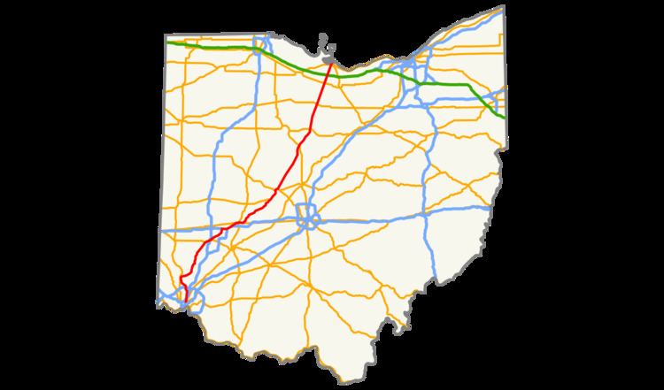
State Route 4 (SR 4), formerly known as Inter-county Highway 4 until 1921 and State Highway 4 in 1922, is a major north–south state highway in Ohio. It is the fifth longest state route in Ohio. Its southern terminus is at U.S. Route 42 in Cincinnati, Ohio, and its northern terminus is at U.S. Route 6 in Sandusky, Ohio. Its path is nearly ruler-straight for many miles. Some portions of the route are still marked as Dixie Highway. The northern portion was constructed by the Columbus and Sandusky Turnpike Company, see Turnpike Lands.
Contents
Route description
State Route 4 begins in Cincinnati, running through Dayton, then joining Interstate 70, with which it runs concurrently for over three miles. The route then goes through Springfield and continues to Marion. It then travels to Bucyrus, finally heading northeast to Sandusky, where it ends.
History
State Route 4 Bypass
State Route 4 By-Pass (SR 4B or SR 4 Bypass) is a 5.97-mile-long (9.61 km) north–south state highway through Butler County in the western part of the state. The route runs from SR 4 in Fairfield to SR 4 in Fairfield Township north of the Hamilton city limits.
SR 4B begins at a quadrant roadway intersection with SR 4 (Dixie Highway) and Ross Road in eastern Fairfield. Here, the connector road is located in the northwest quadrant of the intersection. The route travels north as a divided four-lane road first crossing over a CSX railroad and intersecting Port Union Road. The next three intersections SR 4B has (from south to north Symmes Road, Tylersville Road, and Hamilton Mason Road) are superstreet intersections that opened in 2012. The roadway briefly expands to three lanes in each direction between Symmes Road and Tylersville Road as it crosses over a Norfolk Southern railroad. This segment also features the Fairfield-Hamilton city boundary. After the Hamilton Mason Road intersection, SR 4B comes to a diamond interchange with SR 129 (Butler County Veterans Highway). North of Hamilton Princeton Road, the route shrinks to an undivided two-lane road, passes under an overpass carrying Milliken Road, and ends at a signalized intersection with SR 4. The entirety of SR 4B is included as a part of the National Highway System.
SR 4B was constructed in the early 1970s by ODOT to allow for easier travel between Cincinnati and Middletown. In the 1990s, the Butler County Transportation Improvement District (BCTID) was formed to help address traffic congestion along the fully two-lane bypass route. Construction started on the widening of SR 4B in 2010 which included the widening of the road from the southern terminus to SR 129, the widening of three bridges, and the creation of three superstreet and one quadrant roadway intersections. Construction of the expanded roadway finished in August 2012 and the BCTID is continuing to study the option of widening SR 4B north of SR 129.
Major junctions
The entire route is in Butler County.