
 | ||
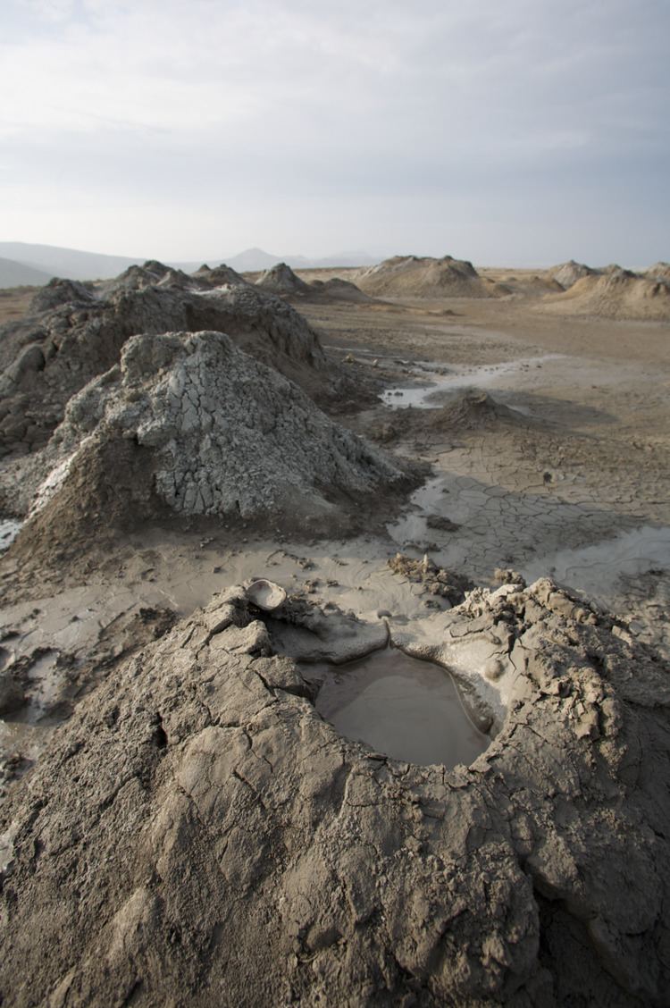
Mud volcano or mud dome refers to formations created by geo-exuded mud or slurries, water, and gases. There are several geological processes that may cause the formation of mud volcanoes. Mud volcanoes are not true igneous volcanoes as they produce no lava. The Earth continuously exudes a mud-like substance, which may sometimes be referred to as a "mud volcano". Mud volcanoes may range in size from merely 1 or 2 meters high and 1 or 2 meters wide, to 700 meters high and 10 kilometers wide. Smaller mud exudations are sometimes referred to as mud-pots. The largest (man made) mud volcano is "Lusi" in Java, Indonesia, which is 10 kilometres (6 mi) in diameter.
Contents
- Details
- Features
- Emissions
- Europe
- Indonesia
- Central Asia
- Azerbaijan
- Iran
- India
- Pakistan
- Philippines
- Other Asian locations
- North America
- Yellowstones Mud Volcano
- Caribbean
- Venezuela
- Colombia
- References
The mud produced by mud volcanoes is most typically formed as hot water, which has been heated deep below the earth's surface, begins to mix and blend with subterranean mineral deposits, thus creating the mud slurry exudate. This material is then forced upwards through a geological fault or fissure due to local subterranean pressure imbalances. Mud volcanoes are associated with subduction zones and about 1100 have been identified on or near land. The temperature of any given active mud volcano generally remains fairly steady and is much lower than the typical temperatures found in igneous volcanoes. Mud volcano temperatures can range from near 100 °C (212 °F) to occasionally 2 °C (36 °F), some being used as popular "mud baths."
About 86% of the gas released from these structures is methane, with much less carbon dioxide and nitrogen emitted. Ejected materials are most often a slurry of fine solids suspended in water that may contain a mixture of salts, acids and various hydrocarbons.
Possible mud volcanoes have been identified on Mars.
Details
A mud volcano may be the result of a piercement structure created by a pressurized mud diapir that breaches the Earth's surface or ocean bottom. Their temperatures may be as low as the freezing point of the ejected materials, particularly when venting is associated with the creation of hydrocarbon clathrate hydrate deposits. Mud volcanoes are often associated with petroleum deposits and tectonic subduction zones and orogenic belts; hydrocarbon gases are often erupted. They are also often associated with lava volcanoes; in the case of such close proximity, mud volcanoes emit incombustible gases including helium, whereas lone mud volcanoes are more likely to emit methane.
Approximately 1,100 mud volcanoes have been identified on land and in shallow water. It has been estimated that well over 10,000 may exist on continental slopes and abyssal plains.
Features
Emissions
Most liquid and solid material is released during eruptions, but seeps occur during dormant periods.
The mud is rich in halite (rock salt).
First-order estimates of mud volcano emissions have been made (1 Tg = 1 million metric tonnes).
Europe
Dozens of mud volcanoes can be found on the Taman Peninsula of Russia and the Kerch Peninsula of Crimea along with the south western portion of Bulgaria near Rupite. In Italy, they are common in the northern front of the Apennines and in Sicily. On August 24, 2013, a mud volcano appeared in the centre of the via Coccia di Morto roundabout in Fiumicino near Rome.
Mud volcanoes can be found in the Berca Mud Volcanoes near Berca in Buzău County, Romania, close to the Carpathian Mountains.
Indonesia
Drilling may have resulted in the Sidoarjo mud flow on May 29, 2006, or an earthquake in the Porong subdistrict of East Java province, Indonesia. The mud covered about 440 hectares, 1,087 acres (4.40 km2) (2.73 mi2), and inundated four villages, homes, roads, rice fields, and factories, displacing about 24,000 people and killing 14. The gas exploration company involved was operated by PT Lapindo Brantas and the earthquake that may have triggered the mud volcano was the 6.3 magnitude Yogyakarta earthquake of May 27, 2006. In 2008, it was termed the world's largest mud volcano. It is beginning to show signs of catastrophic collapse, according to geologists who have been monitoring it and the surrounding area. A catastrophic collapse could sag the vent and surrounding area by up to 150 metres (490 ft) in the next decade. In March 2008, the scientists observed drops of up to 3 metres (9.8 ft) in one night. Most of the subsidence in the area around the volcano is more gradual, at around 1 millimetre (0.039 in) per day. A study by a group of Indonesian geo-scientists led by Bambang Istadi predicted the area affected by the mudflow over a ten-year period. More recent studies carried out in 2011 predict that the mud will flow for another 20 years, or even longer. Now named Lusi – a contraction of Lumpur Sidoarjo, where lumpur is the Indonesian word for "mud" – the mud volcano appears to be a hydrocarbon/hydrothermal hybrid.
Central Asia
Many mud volcanoes exist on the shores of the Black Sea and Caspian Sea. Tectonic forces and large sedimentary deposits around the latter have created several fields of mud volcanoes, many of them emitting methane and other hydrocarbons. Features over 200 metres (656 ft) high occur in Azerbaijan, with large eruptions sometimes producing flames of similar scale. There are mud volcanoes in Georgia, such as at Akhtala.
Iran and Pakistan possess mud volcanoes in the Makran range of mountains in the south of the two countries. A large mud volcano is located in Balochistan, Pakistan. It is known as Baba Chandrakup (literally Father Moonwell) on the way to Hinglaj and is a Hindu pilgrim site.
Azerbaijan
Azerbaijan and its Caspian coastline are home to nearly 400 mud volcanoes, more than half the total throughout the continents. In 2001, one mud volcano 15 kilometres (9 mi) from Baku made world headlines when it started ejecting flames 15 metres (49 ft) high.
In Azerbaijan, eruptions are driven from a deep mud reservoir which is connected to the surface even during dormant periods, when seeping water shows a deep origin. Seeps have temperatures that are generally above ambient ground temperature by 2 °C (3.6 °F) - 3 °C (5.4 °F). Lökbatan Mud Volcano since 1998 submitted to UNESCO's World Heritage Site tentative list.
Iran
There are many mud volcanoes in Iran: in Hormozgan province, Sistan and Baluchestan Province and Golestan Province.
India
The island of Baratang, part of the Great Andaman archipelago in the Andaman Islands, Indian Ocean, has several sites of mud volcanic activity. There was a significant eruption event in 2003.
Pakistan
In Pakistan there are more than 80 active mud volcanoes in Balochistan province; there are about 10 locations with clusters of mud volcanoes. In the west, in Gwadar District, the mud volcanoes are very small and mostly sit in the south of Jabal-e-Mehdi toward Sur Bandar. Many more are in the northeast of Ormara. The remainder are in Lasbela District and are scattered between south of Gorangatti on Koh Hinglaj to Koh Kuk in the North of Miani Hor in the Hangol Valley. In this region, the heights of mud volcanoes range between 800 to 1,550 feet (243.8 to 472.4 m). The most famous is Chandragup. The biggest crater found at 25°33'13.63"N. 65°44'09.66"E is about 450 feet (137.16 m) in diameter. Most mud volcanoes in this region are in out-of-reach areas having very difficult terrain. Dormant mud volcanoes stand like columns of mud in many other areas.
Philippines
In the Turtle Islands, in the province of Tawi-Tawi, the southwestern edge of the Philippines bordering Malaysia, presence of mud volcanoes are evident on three of the islands – Lihiman, Great Bakkungan and Boan Islands. The northeastern part of Lihiman Island is distinguished for having more violent kind of mud extrusions mixed with large pieces of rocks, creating a 20-m (66-ft) wide crater on that hilly part of the island. Such extrusions are reported to be accompanied by mild earthquakes and evidence of extruded materials can be found high in the surrounding trees. Submarine mud extrusions off the island have been observed by local residents.
Other Asian locations
North America
Mud volcanoes of the North American continent include:
Yellowstone's "Mud Volcano"
The name of Yellowstone National Park's "Mud Volcano" feature and the surrounding area is misleading; it consists of hot springs, mud pots and fumaroles, rather than a true mud volcano. Depending upon the precise definition of the term mud volcano, the Yellowstone formation could be considered a hydrothermal mud volcano cluster. The feature is much less active than in its first recorded description, although the area is quite dynamic. Yellowstone is an active geothermal area with a magma chamber near the surface, and active gases are chiefly steam, carbon dioxide, and hydrogen sulfide.
However, there are mud volcanoes and mud geysers elsewhere in Yellowstone. One, the "Vertically Gifted Cyclic Mud Pot" sometimes acts as a geyser, throwing mud up to 30 feet high.
The mud volcano in Yellowstone was previously a mound until suddenly it tore itself apart into the formation seen today.
Caribbean
Venezuela
The eastern part of Venezuela contains several mud volcanoes (or mud domes), all of them having an origin related to oil deposits. The mud of 6 kilometres (3.7 mi) from Maturín, Venezuela, contains water, biogenic gas, hydrocarbons and an important quantity of salt. Cattle from the savanna often gather around to lick the dried mud for its salt content.
Colombia
Volcan El Totumo, which marks the division between Bolívar and Atlantico in Colombia. This volcano is approximately 50 feet (15 m) high and can accommodate 10 to 15 people in its crater; many tourists and locals visit this volcano due to the alleged medicinal benefits of the mud; it is next to a cienaga, or lake. This volcano is under legal dispute between the Bolivar and Atlantico Departamentos because of its tourist value.