
Topo map USGS North Palisade Prominence 200 m | Parent range Sierra Nevada Elevation 4,200 m Mountain range Sierra Nevada | |
 | ||
First ascent June 10, 1923 by Harvey C. Mansfield, John M. Newell, and Windsor B. Putnam Easiest route East Arête, class 3 scramble Similar | ||
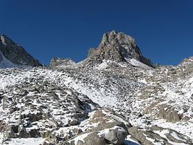
Mount Winchell, a thirteener, is among the thirty highest peaks of California. It is in the Palisades region of the Sierra Nevada, on the Sierra Crest between Mount Agassiz and Thunderbolt Peak.
Contents
Map of Mt Winchell, California, USA
Geography
The Inyo-Kern County line follows Winchell's northwest-southeast ridges. Hydrologically, this same boundary divides the Big Pine Creek drainage from Dusy Basin, part of the Kings River's headwaters. Its west slopes fall within Kings Canyon National Park, while its east slopes are in the John Muir Wilderness of the Inyo National Forest.
History
Two mountain peaks in the vicinity were christened Mount Winchell during the 1870s, but neither of them were present day Mount Winchell. The United States Geological Survey applied the name to the present peak. The name's original application was made by Elisha Winchell for his cousin, Alexander Witchell, who was a founding member of the Geological Society of America.
The first recorded climb of Mount Winchell was by Harvey C. Mansfield, Sr., John M. Newell, and Windsor B. Putnam, in June 1923. Their route, a class 3 scramble up the east arête, is the least technical route. The first known winter climb by Norman Clyde, Morgan Harris, and David Brower used this same route in January 1938.