
Isolation 3.09 mi (4.97 km) Elevation 4,262 m Mountain range Sierra Nevada Parent range Sierra Nevada | Topo map USGS Mount Williamson Prominence 580 m | |
 | ||
Listing North America highest peaks 63rdUS highest major peaks 48thCalifornia highest major peaks 7thSPS Emblem peakWestern States Climbers Star peak First ascent 1898, by Cornelius Beach Bradley, Jennie E. Price, Robert M. Price and Joseph C. Shinn Easiest route Scramble, class 2 by Northwest Face, South Face or Northeast Slopes Similar Junction Peak, Mount Stanford, Mount Barnard, Mount Morgan, Mount Darwin | ||
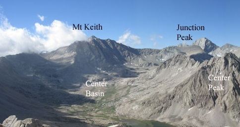
Mount Keith is a mountain on the crest of California's Sierra Nevada, between Mount Bradley to the north, and Junction Peak to the southwest. Its north and west facing slopes feed the Kings River watershed by way of Bubbs Creek, and its east and south slopes feed the Owens River via Shepherd Creek. By the same dividing line, Keith stands on the boundary of Kings Canyon National Park to the northwest, and the John Muir Wilderness to the southeast. It is a thirteener, a mountain which has a height over 13000 feet.
Map of Mt Keith, California, USA
The peak was named for artist and Sierra Club member, William Keith, by Helen Gompertz (later Helen LeConte) in July 1896.
The first ascending party consisted of Cornelius Beach Bradley, Jennie and Robert Price, and Joseph Shinn. Scrambling over boulders and scree from the upper lakes of Center Basin, they made the summit by the Northwest Face route on July 6, 1898.