
Country United States | ||
 | ||
Elevation 14,248 ft (4,343 m) NAVD 88 Length 30 mi (48 km) North-South Width 21 mi (34 km) East-West Districts Fresno County, California, Inyo County, California Similar | ||
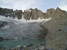
The Palisades (or the Palisade Group) are a group of peaks in the central part of the Sierra Nevada in the U.S. state of California. They are located about 12 miles (19 km) southwest of the town of Big Pine, California. The peaks in the group are particularly steep, rugged peaks and "contain the finest alpine climbing in California." The group makes up about 6 miles (10 km) of the Sierra Crest, which divides the Central Valley watershed from the Owens Valley, and which runs generally northwest to southeast.
Map of Palisades, California 93513, USA
Josiah Whitney in his book Geology, Volume 1 writes:
"At the head of the north fork, along the main crest of the Sierra, is a range of peaks, from 13,500 to 14,000 feet high, which we called 'the Palisades.' These were unlike the rest of the crest in outline and color, and were doubtless volcanic; they were very grand and fantastic in shape."
On the northeast side of the group lie the Palisade Glacier and the Middle Palisade Glacier, the largest glaciers in the Sierra Nevada. These glaciers feed Big Pine Creek.
Notable peaks of the group include four independent fourteeners:
and the following mountains in addition:
North Palisade has some additional subpeaks over 14,000 feet (4,267 m); see the North Palisade article for those summits.