The Mount Vernon Trail, a part of the Potomac Heritage National Scenic Trail, is a 17 miles (27 km) paved hiking/cycling path in Northern Virginia that travels between Rosslyn and George Washington's home at Mount Vernon. The trail travels through the easternmost portions of Arlington County, the City of Alexandria, and Fairfax County. It is part of U.S. Bike Route 1.
The Mount Vernon Trail opened in May 1972 as a gravel path. It was later paved and expanded.
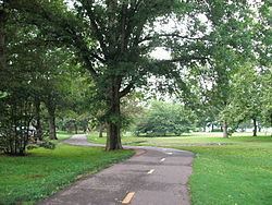
The trail's route parallels the George Washington Memorial Parkway and the western bank of the Potomac River. Most of the northern half of the trail is open and has views of the river and of Washington, D.C. The southern 8 miles (13 km) below Alexandria is largely wooded and has only occasional views of the river.
The northern end of the trail is at a parking lot near Theodore Roosevelt Island. The trail travels south near the Potomac River until it turns inland to pass between the Parkway and the west side of Ronald Reagan Washington National Airport. Before reaching the airport, the trail passes through Gravelly Point, where there are often views of airplanes that are taking off and landing. A connecting trail travels through the airport and provides access to the Ronald Reagan Washington National Airport Metro Station and the Abingdon Plantation historic site.
After passing the airport, the trail crosses Four Mile Run and continues south into the Old Town neighborhood of Alexandria, where it travels on city streets. After crossing under the Woodrow Wilson Bridge and over Hunting Creek, the trail continues south along the Potomac River, traveling near Belle Haven, the west side of Dyke Marsh and the east side of Fort Hunt Park. The last mile before reaching Mount Vernon is a curving uphill inland climb.
The Mount Vernon Trail connects to other area hiker/biker routes including:
East Coast Greenway - a 3,000 mile long system of trails connecting Maine to Florida.Woodrow Wilson Bridge Trail, which crosses the Potomac River and provides access to National Harbor in Prince George's County, Maryland.Four Mile Run Trail, a 7 miles (11 km) paved trail that begins near the boundary between Arlington County and the City of Falls Church and travels east to meet the Mount Vernon Trail south of Ronald Reagan Washington National Airport.Washington & Old Dominion Railroad Trail, a 44.8 miles (72.1 km) paved rail trail that travels northwest from the Arlington County/Alexandria boundary to Purcellville, Virginia (accessed from the Four Mile Run Trail).Rock Creek Park Trail, a paved trail that travels north through Washington, D.C., and Montgomery County, Maryland and ends near Lake Needwood (accessed from the Arlington Memorial Bridge).Chesapeake and Ohio Canal towpath, an unpaved path that travels northwest from Georgetown in Washington, D.C., for 184.4 miles (296.8 km) to Cumberland, Maryland (accessed from the Francis Scott Key Bridge).Capital Crescent Trail, a partially paved rail trail that travels east and south for 11 miles (18 km) from Silver Spring, Maryland| through Bethesda, Maryland to Georgetown (accessed from the Francis Scott Key Bridge).Custis Trail, a 4 miles (6 km) paved trail that begins in Rosslyn at the end of the Mount Vernon Trail, travels west alongside I-66 and connects to the Washington & Old Dominion Railroad Trail.Northern Extension (Potomac Heritage Trail):, a 10 miles (16 km) unpaved hiking trail beginning at the end of the Mount Vernon Trail northwest of Theodore Roosevelt Island and traveling northwest through Arlington and Fairfax Counties in and near the Potomac River gorge and near the George Washington Memorial Parkway. The trail travels near the shoreline of the Potomac River, crosses under the Francis Scott Key Bridge and passes Chain Bridge. The trail then travels inland along Pimmit Run, passes Fort Marcy Park, returns to the Potomac's shoreline and passes Turkey Run Park. The trail ends after passing beneath the American Legion Memorial Bridge, which carries the Capital Beltway (Interstate 495) over the Potomac River.Scenes along the Mount Vernon Trail, from south to north: