
Primary outflows Rock Creek Surface area 75 acres (30 ha) Surface elevation 121 m Outflow location Rock Creek | Primary inflows Area 30 ha Catchment area 33.15 km² Inflow source Rock Creek | |
 | ||
Water volume 196,000,000 US gal (0.00074 km) Similar Rock Creek Regional, Little Seneca Lake, Lake Artemesia, Meadowside Nature Center, Windy Run | ||
12 26 15 flooded bass fishing at lake needwood
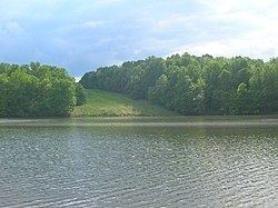
Lake Needwood is a 75-acre (300,000 m2) reservoir in Derwood, Maryland, USA. It is just east of Rockville, in the eastern part of Montgomery County, and is situated on Rock Creek. The lake was created to provide flood control. It also protects the water quality of the creek by functioning as a retention basin to trap sediment from stormwater runoff. Ironically, there have been several evacuations of downstream residents during periods of heavy rain, due to concerns about the structural integrity of the earthen dam constructed in 1965.
Contents
- 12 26 15 flooded bass fishing at lake needwood
- Map of Lake Needwood Redland MD 20855 USA
- Mid Atlantic States flood of 2006Edit
- Dredging projectEdit
- ToxicityEdit
- References
Map of Lake Needwood, Redland, MD 20855, USA
The lake is part of Rock Creek Regional Park. Visitors can rent pedal boats, rowboats, and canoes, and a flat-bottom pontoon boat, the Needwood Queen, is available for rides. With a license, fishing is permitted. Also, the picnic areas surrounding the lake are popular locations for various events. Other park features include a visitors center and snack bar, hiking and biking trails, playgrounds, an archery range and Needwood Golf Course. About one mile (1.6 km) southeast is Lake Needwood's sister lake, Lake Frank.
The Rock Creek Trail begins at Lake Needwood and can be followed along the course of Rock Creek, ending at the Potomac River in Washington, D.C.
Mid-Atlantic States flood of 2006Edit
The latest evacuation, of approximately 2,200 people, was on June 28, 2006. Communities just south of the lake were evacuated and were housed in temporary shelters at nearby high schools until the lake's level dropped. The evacuees lived in 500 apartments at the Rock Creek Terrace complex on Veirs Mill Road in Rockville and in 700 single family homes in that area. Officials stated that the lake was 25 feet (7.6 m) above its normal level during the flood, and many roads in the surrounding area had been closed down for fear of flooding. As soon as fears subsided, evacuees returned home on June 29. Montgomery County Homeland Security director Gordon Aoyagi and County Chief Administrative Officer Bruce Romer estimated that if the dam had broken, areas south of the lake could have flooded up to 19 feet (5.8 m).
Dredging projectEdit
Until 1990, the county government regularly conducted dredging projects of the lake to remove accumulated sediment. Since that time dredging has been deferred for budgetary reasons. In 2008, the County started preparations to dredge sediment from the lake during 2010-2011. The dredging project will improve water quality, as well as boating and fishing conditions.
ToxicityEdit
In 2010, the lake was found to have low levels of microcystin, a toxin produced by cyanobacteria that can cause liver damage. The toxin was also reported in the water in 2012, 2013 and 2014. Approximately 50 bright yellow signs were posted along trails around the lake advising patrons to keep pets away from the water.