
Listing inactive volcanoUltra Country Philippines Prominence 2,922 m Easiest route Ambangeg Trail | Elevation 2,922 m Parent range Cordillera Central | |
 | ||
Isolation 668 kilometres (415 mi) Regions Cordillera Administrative RegionCagayan Valley Municipalities BokodKabayanKayapaTinoc Similar Mount Apo, Mount Dulang‑dulang, Mount Pinatubo, Mount Pico de Loro, Mount Kitanglad | ||
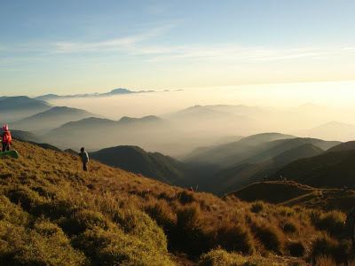
Mt pulag this way to the clouds
Mount Pulag (Ilocano: Bantay Pulag; Filipino: Bundok Pulag) is the 3rd highest mountain in the Philippines. It is Luzon’s highest peak at 2,922 metres (9,587 ft) above sea level. The borders between the provinces of Benguet, Ifugao, and Nueva Vizcaya meet at the mountain's peak.
Contents
- Mt pulag this way to the clouds
- Map of Mount Pulag Kabayan Nueva Vizcaya Philippines
- HistoryEdit
- GeographyEdit
- ClimateEdit
- Fauna and FloraEdit
- Hiking activityEdit
- Presidential helicopter crashEdit
- References
Map of Mount Pulag, Kabayan, Nueva Vizcaya, Philippines
It is the third highest mountain in the Philippines, next to Mount Apo and Mount Dulang-dulang.
Mount Pulag is famous for its "sea of clouds" and the view of the Milky Way Galaxy at dawn, which has attracted many tourists who wish to see the "other-worldly" scenery.
HistoryEdit
The Ibaloi people of Benguet mummify their dead and house them in caverns in the mountain. The Kabayan mummy burial caves, one of the main attraction of the site, are considered Philippine national cultural treasures under Presidential Decree No. 432.
Mt. Pulag was proclaimed a National Park through Pres. Proclamation No. 75 on February 20, 1987 covering an area of 11,550 hectares (28,500 acres). It is part of the Cordillera Biogeographic Zone and is a National Integrated Protected Areas Programme (NIPAP) site.
The National Park is inhabited by different ethnic groups such as the Ibalois, Kalanguya, Kankana-eys, Karao, Ifugaos and the Ilocanos.
GeographyEdit
Mount Pulag stands at 2,922 metres (9,587 ft) high. The peak of the mountain meets the borders of Benguet, Ifugao, and Nueva Vizcaya.
ClimateEdit
Because of its high elevation, the climate on Mount Pulag is temperate with rains predominating the whole year. Rainfall on the mountain averages 4,489 millimetres (176.7 in) yearly with August being the wettest month with an average rainfall of 1,135 millimetres (44.7 in). Snow has not fallen on its top in at least the past 100 years; however, there have been mild flurries on the mountain, especially during December, January and February. Frost is more common on the mountain due to the low temperature during those months. During the amihan season, the temperature in the highest point of the mountain is known to dip into sub-freezing temperatures, making it the coldest place in the country. The only recorded incidence of snow was in the late 1800s.
Fauna and FloraEdit
Mount Pulag hosts 528 documented plant species. It is the natural habitat of the endemic Dwarf Bamboo, (Yushania niitakayamensis) and the Benguet pine (Pinus insularis) which dominates the areas of Luzon tropical pine forests found on the mountainsides. Among its native wildlife are 33 bird species and several threatened mammals such as the Philippine Deer, Giant Bushy-Tailed Cloud Rat (bowet) and the Long-Haired Fruit Bat. Mount Pulag is the only place that hosts the four cloud rat species. It is one of the most biodiverse locations in the Philippines, with the newly found (since 1896) 185-grams Dwarf cloud rat, Carpomys melanurus, a rare breed (endemic to the Cordillera) and the Koch pitta bird among its endangered denizens.
Hiking activityEdit
As the highest mountain in Luzon, Mount Pulag attracts a lot of mountain climbers. Highlights of the climb include the montane forests and the grassland summit with its "sea of clouds" phenomenon. There are four major trails up the summit: the Ambangeg, Akiki, and Tawangan trails from Benguet and the Ambaguio trail from Nueva Vizcaya. These trails are managed by the Mount Pulag National Park, under the Department of Environment and Natural Resources.
Presidential helicopter crashEdit
On 7 April 2009 a Philippine Air Force (PAF) Bell 412 of the 250th Presidential Airlift Wing crashed at 6,900 feet (2,100 m) above sea level in the Kabayan-Pulag pass between Mount Mangingihi and Mount Pulag in thick low cloud and fog. The aircraft pilots and their passengers, who were presidential appointees, died in the crash.