
Age of rock Pliocene-Quaternary First ascent 10 October 1880 Parent range Apo–Talomo | Elevation 2,954 m Prominence 2,954 m | |
 | ||
Isolation 905 kilometres (562 mi) Listing Country's highest pointUltra prominent peaks Regions Davao RegionSOCCSKSARGEN First ascenders Joseph Montano, Joaquin Rajal, Father Mateo Gisbert Similar Mount Dulang dulang, Mount Pulag, Taal Volcano | ||
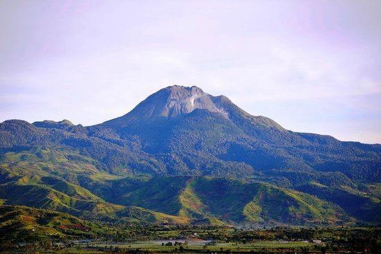
Mount Apo is a large solfataric, potentially active stratovolcano in the island of Mindanao, Philippines. With an Elevation of 2,954 metres (9,692 ft) above sea level, it is the highest mountain in the Philippine Archipelago and is located between Davao City and Davao del Sur province in Region XI and Cotabato Province in Region XII. The peak overlooks Davao City 45 kilometres (28 mi) to the northeast, Digos City 25 kilometres (16 mi) to the southeast, and Kidapawan City 20 kilometres (12 mi) to the west.
Contents
- Map of Mount Apo Davao City Davao del Sur Philippines
- Mount Apo Natural ParkEdit
- UNESCO World Heritage listEdit
- ClimateEdit
- Flora and faunaEdit
- Bodies of waterEdit
- Biological featuresEdit
- Geothermal energyEdit
- Watershed and hydroelectric plantsEdit
- Indigenous peoplesEdit
- Hiking activityEdit
- Hydrological featuresEdit
- References
Map of Mount Apo, Davao City, Davao del Sur, Philippines
The first two attempts to reach Mt. Apo’s summit ended in failure: that of Jose Oyanguren (1852) and Señor Real (1870). The first recorded successful expedition was led by Don Joaquin Rajal in October 10, 1880. Prior to the climb, Rajal had to secure the permission of the Bagobo chieftain, Datu Manig. It is said that the Datu demanded that human sacrifice be made to please the god Mandarangan. Fortunately, the datu agreed to waive this demand, and the climb commenced on October 6, 1880, succeeding five days later. Since then, numerous expeditions followed. These and more are described in colorful narrations by Fr. Miguel Bernad, S.J.
On May 9, 1936, Mount Apo was declared a national park by President Manuel L. Quezon.
Mt. Apo is said to be named after a nobleman named Apong, who was killed while mediating the battle between two suitors of his daughter Saribu. Another proposed origin of the name is from the word Apo itself, which in Filipino tongues means “master” or “grandchild."
In late March-April 2016, due to the extreme effects of El Niño, massive patches of forest fires and Bushfires appeared on the slopes of the mountain, causing hikers on the mountain to halt their ascent. Tourism in the region was threatened due to a massive haze engulfing the slopes of the mountain.
Mount Apo Natural ParkEdit
On May 9, 1936, Mount Apo was declared a national park with Proclamation No. 59 by President Manuel L. Quezon, followed by Proclamation No. 35 of May 8, 1966, then Proclamation No. 882 of September 24, 1996. On February 3, 2004, the approval of Republic Act No. 9237 established Mount Apo as a protected area under the category of Natural Park with an area of 54,974.87 hectares (135,845.9 acres); with two peripheral areas of 2,571.73 hectares (6,354.9 acres) and 6,506.40 hectares (16,077.7 acres) as buffer zones, provided for its management and for other purposes.
Although a declared a Natural Park, the current climbing trails are littered with rubbish by irresponsible climbers, opening paths for soil erosion across the already denuded mountain sides. Some mountain and social climbing groups conduct climbs after the Holy Week/Easter, the peak climbing season, to clean the affected areas.
UNESCO World Heritage listEdit
The Department of Environment and Natural Resources (DENR) submitted Mount Apo on December 12, 2009 for inclusion in the UNESCO world heritage list. The mountain is considered by DENR as the center of endemism in Mindanao. It has one of the highest land-based biological diversity in terms of flora and fauna per unit area. It has three distinct forest formations, from lowland tropical rainforest, to mid-mountain forests, and finally to high mountain forests.
A portion of the eastern slopes are also within the scope of the UNESCO Hydrology Environment Life and Policy (HELP) Network. The Davao HELP Network is focused on building collaboration among watershed stakeholders.
In March 2015, it was taken out from the UNESCO List of Tentative Sites due to the dramatic changes (such as logging, intrusion of companies and urban and agricultural landscape, exploitation, and poaching, among others) it experienced which does not constitute the UNESCO documents that describes the park. Better conservation and a change in the content of documents was recommended by UNESCO.
ClimateEdit
Mt. Apo generally enjoys tropical rainy climate. It falls under the Type IV climate under the modified corona's classification wherein rainfall is relatively distributed throughout the year. Mean monthly temperature ranges from a low 26.4 °C (79.5 °F) during January to 27.9 °C (82.2 °F) during April. Monthly relative humidity ranges from 78% during March and April and 82% during June and July.
Flora and faunaEdit
The mountain is home to over 272 bird species, 111 of which are endemic to the area. It is also home to one of the world's largest eagles, the critically endangered Philippine eagle, which is the country’s national bird.
Bodies of waterEdit
Lakes - There are four major lakes in Mt. Apo . Popular of these are Lake Agco, used to be called "The Blue Lake" and Lake Venado, a well-known mountaineers camping site and a stopover towards the peak. Lake Macadac and Lake Jordan are found in the summit grassland.
Rivers - Mt. Apo has 19 major rivers and 21 creeks draining its 8 major watersheds (PASAlist.1992). Out of the 19 major rivers, only two has studies as reported by SEA-BMB consultants for the Mt. Apo Geothermal Project Environmental Impact Assessment 1991. According to the report, there are two river ecosystems draining the geothermal site namely: (1) Marbel-Matingao river ecosystem- characterized by narrower river channels at highly elevated areas, much faster water flow, clearer water and rock boulder-rich water beds. The aquatic organisms in the area have expectedly lower biological productivity and species diversity. The report also concluded that this river ecosystem provides much less economic and commercial value for its biological production. The study identified 12 species of fish caught in the area; (2) Kabacan River- Pulangi River ecosystem- characterized by a much wider channels at flat areas, relatively much slower water flow, highly turbid waters and sandy mud river beds.
Waterfall the Tudaya Falls Davao del Sur, in Mindanao in the Philippines. At 100 metres, it is the tallest waterfall in Mt. Apo Natural Park.[1] This waterfall flows into the Sibulan River, which flows to the Davao Gulf.
Biological featuresEdit
Grasslands - The grasslands are characterized by the dominance of Cogon grass (Imperata cylindrica) and Saccharum spontaneum. Other grasses and ferns also thrive, especially along banks of creeks, streams, and rivers and on steep slopes.
Geothermal energyEdit
The Mt. Apo 1 and Mt. Apo 2 geothermal plants, each possess a rated capacity of 54.24 megawatts. Owned and operated by Energy Development Corporation (EDC) the power plants were commissioned in February 1997 (Mt. Apo 1) and June 1999 (Mt. Apo 2) respectively, under a build-operate owner contract arrangement. Located in Barangay Ilomavis, Kidapawan City, North Cotabato is the Mindanao Geothermal Production Field with a power output of 108.48 MW, currently the only power plant of its kind in Mindanao.
The Philippine National Oil Company geothermal plant supplies electricity to Kidapawan and its neighboring provinces, its completion boosted the city's economy.
Watershed and hydroelectric plantsEdit
The Tudaya Hydropower Plants, located near the foot of Mount Apo on the Davao side (Sta. Cruz, Davao del Sur), is composed of two run-of-river type plants that will contribute to the energy needs of Mindanao by early 2014.
The Sibulan Hydroelectric Power Plants have been generating 42.5 MW of clean and renewable energy for Davao since 2010. The first of two cascading plants, Sibulan A Hydro produces 16.5 MW and the water it utilizes is re-used in the Sibulan B Hydro to produce 26 MW.
Sibulan A was completed and commissioned on December 26, 2010. Local residents who are mainly engaged in abaca and fruit farming have since benefited from the use of 44 kilometres (27 mi) of farm-to-market roads which were developed as access to the plants.
Indigenous peoplesEdit
Six indigenous groups, the Manobos, Bagobo, Ubos, Atas, K’Iagans and Tagacaolo, live in the area of Mount Apo. They consider the mountain to be sacred ground and a place of worship. A number of genealogies of Lumad leaders in South Central Mindanao trace their roots to Mount Apo. For the Lumads, the term "Apo" was coined from the name of their great grandparent Apo Sandawa.
Hiking activityEdit
At 2,954 meters (9,692 ft), Mount Apo is the highest mountain & volcano in the Philippines. It is one of the country's most popular climbing destinations.
Several trails lead to the summit, coming from North Cotabato and Davao provinces. Arguably the easiest route to the National Park is through Kidapawan with an average hike taking 3–4 days roundtrip. In the classification system used by local popular mountaineering website PinoyMountaineer.com, the difficulty of the hike is 7 out of 9. Various sights along the trail include Lake Venado, the highest lake in the Philippines, the solfataras and the old crater near its summit.
Hydrological featuresEdit
Mount Apo is a headwaters catchment area of several major river systems like Marble River, Matingaw River, connecting with the Kabacan River, part of the Pulangi River, a major tributary of the Mindanao River, the Tudaya Falls, Sibulan River , and Digos River, which flows into Davao Gulf.