
Translation Riding Saddle Peak Last eruption 50 BCE (?) Elevation 3,026 m | First ascent Enkū in the 1680s Prominence 1,236 m | |
 | ||
Topo map Geographical Survey Institute, 25000:1 乗鞍岳, 50000:1 上高地 Similar Mount Hotakadake, Mount Yake, Mount Ontake, Mount Yari, Mount Kasa | ||
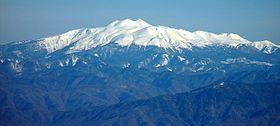
Mount Norikura (乗鞍岳, Norikura-dake) is a potentially active volcano located on the borders of Gifu and Nagano prefectures in Japan. It is part of the Hida Mountains and is listed among the 100 Famous Japanese Mountains and the New 100 Famous Japanese Mountains.
Contents
- Map of Mount Norikura Nyukawacho Iwaidani Takayama Gifu Prefecture 506 2254 Japan
- Outline
- History
- Nature
- Plant and animal life
- Geological features
- River of source
- References
Map of Mount Norikura, Nyukawacho Iwaidani, Takayama, Gifu Prefecture 506-2254, Japan
Outline
The mountain is located on the borders of Gifu and Nagano prefectures in Chūbu-Sangaku National Park.
The Norikura Plateau borders the mountain on its northern side in Nagano Prefecture. The mountain, whose name means "riding saddle," received its name because its shape looks like a horse saddle.
It is known for being the easiest to climb among the mountains in Japan that are above 3000-meters.
History
Nature
After Mount Fuji and Mount Ontake, Mount Norikura is the third tallest volcano in Japan. It is a stratovolcano and hardened lava flows can still be seen near the peak. There are eight plains and 12 crater lakes on the mountain that were formed by volcanic activity. The Norikura Skyline is a road through the mountain, but it has to be closed for much of the year because of heavy snow fall. Even in the summer, some snow remains on the northeastern face of the mountain.
Plant and animal life
Mount Norikura has a variety of plant and animal life on its slopes. In addition to the alpine accentor and martins, the rock ptarmigan (one of Japan's natural monuments) also makes its home on the mountain.
There are various alpine plants and other flowers, including rhododendrons, lilies, and komakusa.
Geological features
Mount Kengamine (剣ヶ峰 Kengamine), one peak on the mountain, was formed in two eruptions 9,600 and 9,200 years ago. Mount Ebisu (恵比寿岳 Ebisu-dake), another peak, was formed during an eruption 2,000 years ago. Though the volcano has lost some of its eruptive power, volcanic gas is still escaping through the Yū River (湯川 Yū-gawa) and there are many spa areas in the surrounding area.
River of source
The each following River of the source flows to the Sea of Japan or Ise Bay.