
Translation spear (Japanese) First ascent 28 July 1828 | Elevation 3,180 m Prominence 432 m Easiest route Hiking | |
 | ||
Pronunciation Japanese: [jaɽiɡatakeꜜ] Similar Mount Hotakadake, Mount Jōnen, Mount Tsubakuro, Mount Yake, Mount Tsurugi | ||
Hotakadake 2015
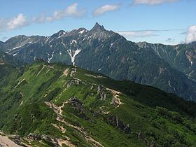
Mount Yari (槍ヶ岳, Yari-ga-take) is one of the 100 Famous Japanese Mountains. The 3,180 m (10,433 ft) high peak lies in the southern part of the Hida Mountains (Northern Alps) of Japan, on the border of Ōmachi and Matsumoto in Nagano Prefecture and Takayama in Gifu Prefecture. The priest Banryū (1786–1840) founded a temple there.
Contents
- Hotakadake 2015
- Map of Mt Yarigadake Taira Omachi Nagano Prefecture 398 0001 Japan
- Mt yari kita alps japan
- History
- Outline
- Surroundings
- Main ascent routes
- References
Map of Mt. Yarigadake, Taira, Omachi, Nagano Prefecture 398-0001, Japan
Mt yari kita alps japan
History
Outline
Mount Yari is located in the Chūbu-Sangaku National Park. The name derives from its shape, which resembles a spear (槍 yari) thrust into the sky. Because of its shape, it is also called the Matterhorn of Japan. Ridges and valleys reach out from this pyramid-shaped mountain in all directions. The four ridges are Higashikama (東鎌), Yarihotaka (槍穂高), Nishikama (西鎌) and Kitakama (北鎌) to the east, south, west and north, respectively. The four valleys are Yarizawa (槍沢), Hidazawa or Yaridaira (飛騨沢 or 槍平), Senjōzawa (千丈沢) and Tenjōzawa (天丈沢) to the southeast, southwest, northwest and northeast, respectively.
During the hiking season, Mount Yari is popular with mountain climbers. One of the most famous but dangerous ridges is Kitakama. It became famous through its association with mountaineer Buntarō Katō (加藤 文太郎, Katō Buntarō), who was a model for the novel Kokō no Hito (孤高の人) by Jirō Nitta. The disaster of Akira Matsunami (松濤明, Matsunami Akira) told in Fūsetsu no Bibāgu (風雪のビバーグ Snowstorm Bivouac) also contributed to its fame.
Despite the existence of variation routes, climbers stand in line for the famous routes during the summer. In the autumn of 2005, a new mountain trail was constructed going up from Hidarimata Valley (左俣谷 Hidarimata-dani) to Mount Okumaru (奥丸山 Okumaru-yama). This made it possible to reach Yari-ga-take walking from Shinhodaka onsen upstream along the Hidarimata Valley following the mountain ridge of Mount Okumaru.
Two triangulation points were established at the summit. A milepost stone is fixed to the ground. As a reference point for the Geographical Survey Institute of Japan, it is of little importance and even on topographic maps, the summit of Yari-ga-take appears merely as an elevation point.
Surroundings
There are several mountain huts in the vicinity of the mountain: Yari-ga-take Sansō (槍ヶ岳山荘), Sesshō Hut (殺生ヒュッテ), Hut Ōyari (ヒュッテ大槍), Yarisawa Lodge (槍沢ロッジ), Yaridaira-goya (槍平小屋) and Wasabidaira-goya (わさび平小屋). Being situated in the Japanese Alps, several prominent mountains can be reached from Mount Yari, among them: Sugoroku-dake (双六岳), Nishi-dake (西岳), Ōgui-dake (大喰岳), Naka-dake (中岳), Minami-dake (南岳), Okumaru-yama (奥丸山).