
Pronunciation [kasaɡatake] First ascent 1683 | Elevation 2,897 m First ascender Enkū Easiest route Hiking | |
 | ||
Topo map Geospatial Information Authority 25000:1 笠ヶ岳50000:1 上高地 Similar Mount Hotakadake, Mount Yari, Mount Kurobegorō, Mount Yake, Mt Sugoroku | ||
Absolute drift mount kasa
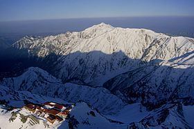
Mount Kasa (笠ヶ岳, Kasa-ga-take) is one of the 100 Famous Japanese Mountains, reaching the height of 2,897 m (9,505 ft). It is situated in Japan's Hida Mountains in Gifu Prefecture and in Chūbu-Sangaku National Park. The shape of the mountain looks like the Umbrella("Kasa"-笠) in the triangle. Therefore, it became this name. There are many mountains with same name in Japan and this is the tallest.
Contents
- Absolute drift mount kasa
- Map of Kasaga take Kamitakaracho Kanakido Takayama Gifu Prefecture 506 1308 Japan
- Absolute drift ps4 1st mount kasa minko rap
- History
- Main ascent routes
- Mountain hut
- Geography
- Nearby mountains
- Rivers
- References
Map of Kasaga-take, Kamitakaracho Kanakido, Takayama, Gifu Prefecture 506-1308, Japan
Absolute drift ps4 1st mount kasa minko rap
History
Main ascent routes
There are three climbing routes to the top of the mountain.
Mountain hut
Thera are several Mountain hut around Mount Kasa. Around Shin-Hotaka-Onsen, there are many hot spring (Onsen) to take the tiredness and to relax.
Geography
It is the mountain that consists chiefly of the Porphyry (geology). The higher region than Shakushi-daira(杓子平) are the forest limit of Siberian Dwarf Pine belt, and the place that Alpine plant grows naturally and Rock Ptarmigan live.
Nearby mountains
Mount Kasa is on the subridge (from Mount Sugoroku) of the main ridge line in the southern part of the Hida Mountains. There are Mount Shakujō and Mount Ōkibanotsuji on the southern ridge.
Rivers
The mountain is the source of the following rivers, each of which flows to the Sea of Japan.