
Country Japan Source Mount Kobushi River mouth Sea of Japan | Length 367 km Basin size 11,900 km2 (4,600 sq mi) | |
 | ||
Discharge Average rate:
514 m/s (16.2 km/a; 18,200 cu ft/s) Main source Mount Kobushi; 2,475 m (8,120 ft) Mouth Sea of Japan (also known as East Sea) Bridges Bandai Bridge, Koshiji Bridge, Ōishi Bridge | ||
Nagaoka fireworks festival by the shinano river
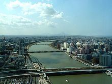
The Shinano River (信濃川, Shinano-gawa) is the longest and largest river in Japan. It flows from Nagano Prefecture to Niigata Prefecture. It is called the Chikuma River (千曲川, Chikuma-gawa) in Nagano Prefecture.
Contents
Map of Shinano River, Japan
The river rises from Mount Kobushi on the border of Saitama, Yamanashi and Nagano, and flows northwest to meet the Sai River from Matsumoto. Kawanakajima (川中島), the junction of the Chikuma and the Sai, is the historic site of the Battles of Kawanakajima. It turns to the northeast and empties into the Sea of Japan at Niigata City.
In 1922, the Ōkōzu Canal (大河津分水路, Ōkōzu Bunsuiro) was built to defend Niigata from floods. It enabled the Niigata Plains to be filled with rich rice fields.
The name Chikuma was given to two Imperial Japanese Navy cruisers.