
Pronunciation [ku͍ɽobeɡoroːdake] | Elevation 2,897 m Easiest route Hiking | |
 | ||
Topo map Geospatial Information Authority 25000:1 三俣蓮華岳50000:1 槍ヶ岳 Similar Mt Washiba, Mt Suisho, Mount Yakushi, Mt Mitsumata‑Renge, Mt Kitanomata | ||
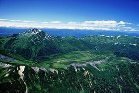
Mount Kurobegorō (黒部五郎岳, Kurobegorō-dake) is one of the 100 Famous Japanese Mountains, reaching the height of 2,839.58 m (9,316 ft). It is situated in Japan's Hida Mountains in Gifu Prefecture and Toyama Prefecture. It was specified for Chūbu-Sangaku National Park on December 4, 1934.
Contents
- Map of Mount KurobegorC58D Kamitakaracho Kanakido Takayama Gifu Prefecture 506 1308 Japan
- Outline
- Mountaineering
- Main ascent routes
- Mountain hut
- Alpine plant
- Rivers
- References
Map of Mount Kurobegor%C5%8D, Kamitakaracho Kanakido, Takayama, Gifu Prefecture 506-1308, Japan
Outline
The origin of the mountain name is the meaning that the stone rolls. It is said "gōro" in Japanese. Also this mountain is located in the source part of the Kurobe River. Then it is called "Kurobe-Gorō". In the hillside on the east side, there is big Cirque geographical features that is the hollow where the shovel was scooped out. The upper part of this mountain is situated in Tree line region, Siberian Dwarf Pine and Alpine plant grow naturally. There are quite a lot of kinds of alpine plant in the surrounding, and it is selected to "the 100 famous Japanese mountains of flower" by Sumie Tanaka.
Mountaineering
In December 1931, Buntarō Katō of Japanese mountain climbers had climbed it alone.
Main ascent routes
There are several climbing routes to the top of the mountain.
There are the Ridge Line and Cirque routes from the Kurobegorō hut to the top.
Mountain hut
Thera are several mountain huts around Mount Kurobegorō.
Alpine plant
A lot of Alpine plant are seen in the surrounding.
Rivers
The mountain is the source of the following rivers, each of which flows to the Sea of Japan.