
Elevation 2,300 m | Easiest route basic snow/ice climb Age of rock 2.838882517 billion years | |
 | ||
First ascent 1960, by a survey party from Mawson Station which included Terence James Elkins, Sydney L. Kirkby, and Neville Joseph Collins People also search for | ||
Mount Elkins, also known as Jökelen (which means "The Glacier") is a dark, steep-sided mountain with three major peaks, the highest 2,300 meters (7,500 ft) above sea level, in the Napier Mountains of Enderby Land. Enderby Land is part of the Australian Antarctic Territory, in East Antarctica. The mountain was named after Terence James Elkins, an ionospheric physicist with the Australian National Antarctic Research Expeditions at Mawson Station in 1960.
Contents
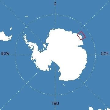
- Map of Mount Elkins Antarctica
- Location
- Geology orogeny
- Ecology
- Significance to mountaineers
- Weather conditions
- Nearby terrain features
- History
- References
Map of Mount Elkins, Antarctica
Location
Some notable geographic features in the general vicinity of Mount Elkins include Cape Batterbee (92 km to the north), the Young Nunataks (7.4 km to the south), Sørtoppen Nunatak (30 km to the east), the Newman Nunataks (26 km to the west), Mount McMaster (97 km to the west), and Mount Kjerringa (57 km to the northeast). The nearest permanently inhabited place is Mawson Station, an Australian research station to the southeast. Molodyozhnaya Station, a former Soviet research station which was mothballed in 1989, is located to the southwest of Mount Elkins.
Mount Elkins is the highest peak in the Napier Mountains. It is the second highest peak in Enderby Land, behind Mount McMaster, whose summit lies at 2830 metres above sea level.
Geology & orogeny
Much of the East Antarctic craton was formed in the Precambrian period by a series of tectonothermal orogenic events. Napier orogeny formed the cratonic nucleus approximately 4 billion years ago. Mount Elkins is a classic example of Napier orogeny. Napier orogeny is characterized by high-grade metamorphism and plate tectonics. The orogenic events which resulted in the formation of the Napier Complex (including Mount Elkins) have been dated to the Archean Eon. Radiometrically dated to as old as 3.8 billion years, some of the zircons collected from the orthogneisses of the Napier Complex are among the oldest rock specimens found on Earth. Billions of years of erosion and tectonic deformation have exposed the metamorphic rock core of these ancient mountains.
The oldest crustal components found to date in the Napier Complex appear to be of igneous derivation. This rock appears to have been overprinted by an ultra-high temperature metamorphic event (UHT) that occurred near the Archean-Proterozoic boundary. Using a lutetium-hafnium (Lu-Hf) method to examine garnet, orthopyroxene, sapphirine, osumilite and rutile from this UHT granulite belt, Choi et al determined an isochron age of 2.4 billion years for this metamorphic event. Using SHRIMPU–Pb zircon dating methodology, Belyatsky et al determined the oldest tectonothermal event in the formation of the Napier Complex to have occurred approximately 2.8 billion years ago.
Preservation of the UHT mineral assemblage in the analyzed rock suggests rapid cooling, with closure likely to have occurred for the Lu-Hf system at post-peak UHT conditions near a closure temperature of 800 °C. UHT granulites appear to have evolved in a low Lu-Hf environment, probably formed when the rocks were first extracted from a mantle profoundly depleted in lithophile elements. The source materials for the magmas that formed the Napier Complex were extremely depleted relative to the chondritic uniform reservoir (CHUR). These results also suggest significant depletion of the early Archean mantle, in agreement with the early igneous differentiation of the Earth that the latest core formation models require.
Ecology
To date, no flora has been observed at Mount Elkins.
The following species have been sighted within 1.0 degrees of Mount Elkins:
Significance to mountaineers
The summit of Mount Elkins is higher than that of any mountain in Australia—including even Mount Kosciuszko (2,228 metres), which is one of the Seven Summits. Because of its remoteness it has not become a popular target for peak bagging.
Weather conditions
The Napier Mountains run northwest from Mount Elkins. To the east is a large valley formed by the Robert and Wilma Glaciers. To the northeast are the Seaton and Rippon Glaciers. All of these glaciers run into the King Edward Ice Shelf. Other notable terrain features in this area include the Beaver Glacier, located to the west of Mount King. Collectively, these terrain features significantly modify weather produced by synoptic scale systems. Dramatic changes can occur over short distances and in short time intervals.
Nearby terrain features
Place names within 1.0 degrees of Mount Elkins (Latitude 66°40.0'S Longitude 54°09.0'E)
History
Mount Elkins was first mapped by Norwegian cartographers from aerial photographs taken by the Lars Christensen Expedition, 1936–37, and named at that time Jökelen (The Glacier). It was remapped by ANARE from aerial photographs taken from an ANARE aircraft in 1956. The Napier Mountains were first visited by an ANARE survey party from Mawson Station in 1960. The survey party was led by Syd Kirkby, and included Terence James Elkins.